State Road 45 (Serbia)
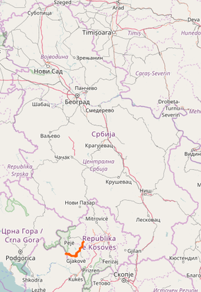
State Road 45 is an IB-class road in southern Serbia, connecting Dolac with Morina. It is located in Kosovo and Metohija.[1] The road is controlled by Kosovo government and UNMIK.
| ||||
|---|---|---|---|---|
| ||||
 | ||||
| Route information | ||||
| Maintained by JP "Putevi Srbije" | ||||
| Length | 52.988 km (32.925 mi) (On territory of Kosovo)[lower-alpha 1] | |||
| Major junctions | ||||
| From | Dolac | |||
| To | Serbia/Kosovo-Albania border at Morina, State Road SH-22 | |||
| Location | ||||
| Districts | Peć (Constitution of Serbia) / Peć, Gjakova (UNMIK) | |||
| Highway system | ||||
IB-Class Highways in Serbia
| ||||

Before the new road categorization regulation given in 2013, the route wore the name M 9.1.[2][3]
The existing route is a main road with two traffic lanes. By the valid Space Plan of Republic of Serbia the road is not planned for upgrading to motorway, and is expected to be conditioned in its current state.[4]
Sections
| Section number | Length | Distance | Section name |
|---|---|---|---|
| 04501 | 13.727 km (8.530 mi) | 13.727 km (8.530 mi) | Dolac (Hramovik) - Hramovik |
| 04502 | 17.401 km (10.812 mi) | 31.128 km (19.342 mi) | Hramovik - Đakovica (Bistražin) |
| 04503 | 1.829 km (1.136 mi) | 32.957 km (20.479 mi) | Đakovica (Bistražin) - Đakovica (Ćafa Prušit) |
| 04504 | 12.817 km (7.964 mi) | 45.774 km (28.443 mi) | Đakovica (Ćafa Prušit) - Ponoševac |
| 04505 | 7.214 km (4.483 mi) | 52.988 km (32.925 mi) | Ponoševac - Serbia/Kosovo-Albania border (Morina) |
See also
Notes
- Kosovo is the subject of a territorial dispute between the Republic of Kosovo and the Republic of Serbia. The Republic of Kosovo unilaterally declared independence on 17 February 2008, but Serbia continues to claim it as part of its own sovereign territory. The two governments began to normalise relations in 2013, as part of the 2013 Brussels Agreement. Kosovo is currently recognized as an independent state by 97 out of the 193 United Nations member states. In total, 112 UN member states recognized Kosovo at some point, of which 15 later withdrew their recognition.
References
- "Republic of Serbia - national road network" (PDF). Putevi Srbije (in Serbian).
- "National road categorization regulation - Official Gazette of Republic of Serbia no. 105/2013 and 119/2013" (PDF). Serbian Spatial Planners Association (in Serbian).
- "Link between actual and previous section and road markings" (PDF). Putevi Srbije (in Serbian).
- Space plan of Republic of Serbia from 2010 to 2021
External links
This article is issued from Wikipedia. The text is licensed under Creative Commons - Attribution - Sharealike. Additional terms may apply for the media files.