St. Croix Island (Algoa Bay)
St. Croix Island is the largest of three islands in Algoa Bay, South Africa located within 8 kilometres of the Port of Nqgura. The islands are of critical importance to sea bird populations, including the endangered African penguin.
St. Croix Island
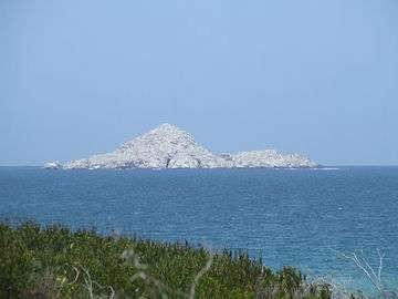
St. Croix Island at 33°47′58″S 25°46′11″E is 3.9 km (2.4 mi) from the nearest land and rises to 59 m (194 ft).[1] The BirdLife fact sheet states the 12 ha (30 acres) island is only 58 m (190 ft) above sea level. It adds that the island is rocky and “supports minimal vegetation”. The island runs 700 m (2,300 ft) along a northwest, southeast axis and is about 360 m (1,180 ft) wide at its broadest – along the west coast. Its highest point is halfway along the north coast. Bartholomeu Dias planted a padrão and celebrated Mass on the island in March 1488. With 22,000 African penguins breeding on the island it is the largest breeding colony of this penguin species. Boat trips out of Port Elizabeth take tourists to see these birds.
In 2019, the penguins of St. Croix island were impacted by an oil spill at the Port of Ngqura.[2]
Brenton Island
Brenton Island (33°49′3″S 25°45′54″E) is equally sparsely vegetated and is less than 20 m (66 ft) in elevation, and is roughly 250 m × 200 m (820 ft × 660 ft) in size with a northwest-southeast orientation. It is 5.75 km (3.57 mi) to sea from the nearest point on the mainland and 1.75 km (1.09 mi) south of St. Croix. It is named after Naval Commissioner Sir Jahleel Brenton.
Jahleel Island
Jahleel, at less than 10 m (33 ft) in height, is just over 1 km (0.62 mi) from the closest beach and less than that from the Port of Ngqura’s 2.6 km (1.6 mi) long eastern breakwater. Jahleel is about the same size as Brenton and has a north-south axis. It is 5.75 km (3.57 mi) west of St. Croix, and is named after Sir Jahleel Brenton.
References
- Ordnance map 3325DC & DD 3425BA, Port Elizabeth (Map). Chief Directorate Mapping and Surveying of the national Department of Land Affairs.
- "Refuelling under scrutiny as S.Africa penguins hit by oil spill". phys.org. Retrieved 2020-04-23.