Spuyten Duyvil, Bronx
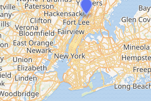
Spuyten Duyvil /ˈspaɪtən ˈdaɪvəl/ is an upper middle class neighborhood of the Bronx, New York City. It is bounded on the north by Riverdale, on the east by Kingsbridge, on the south by the Harlem River, and on the west by the Hudson River,[3] although some consider it to be the southernmost part of Riverdale.[4]
Spuyten Duyvil | |
|---|---|
Neighborhood of the Bronx | |
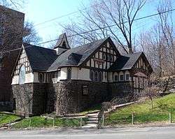 Looking northwest at Edgehill Church of Spuyten Duyvil | |
Location in New York City | |
| Coordinates: 40.881°N 73.917°W | |
| Country | |
| State | |
| City | |
| Borough | |
| Community District | The Bronx 8 [1] |
| Area | |
| • Total | 1.23 km2 (0.473 sq mi) |
| Population (2011)[2] | |
| • Total | 10,279 |
| • Density | 8,400/km2 (22,000/sq mi) |
| Economics | |
| • Median income | $83,381 |
| ZIP Codes | 10463, 10471 |
| Area code | 718, 347, 929, and 917 |
| Website | www |
Etymology
The area is named after Spuyten Duyvil Creek. "Spuyten Duyvil" may be literally translated as "Spouting Devil" or Spuitende Duivel in Dutch; a reference to the strong and wild tidal currents found at that location. It may also be translated as "Spewing Devil" or "Spinning Devil", or more loosely as "Devil's Whirlpool" or "Devil's Spate." Spui is a Dutch word involving outlets for water.[5][6][7] Historian Reginald Pelham Bolton, however, argues that the phrase means "sprouting meadow", referring to a fresh-water spring.[8]
An additional translation, "to spite the Devil" or "in spite of the devil", was popularized by a story in Washington Irving's A Knickerbocker's History of New York published in 1809. Set in the 17th Century, the story tells of trumpeter Anthony Van Corlaer summoned by Dutch colonial governor Peter Stuyvesant to warn settlers of a British invasion attempt, with Corlaer attempting to swim across the creek in treacherous conditions.[6][7][9][10] The creek was referred to as Shorakapok by Lenape Native Americans in the area, translated as “the sitting down place” or “the place between the ridges”.[6]
History
In 1642, Anthony Van Corlaer died while attempting to swim across the Hudson from Spuyten Duyvil[9] A witness to Van Corlaer's death stated that "the devil" in the shape of a giant fish swam up and proceeded to "seize the sturdy Anthony by the leg and drag him beneath the waves."[11] This may be the earliest recorded shark attack in the New World.[11]
In the late 17th century, Frederick Philipse, the lord of Philipse Manor in Westchester County, received permission to construct a bridge across Spuyten Duyvil Creek and charge tolls. "King's Bridge", which was located roughly south of and parallel to where West 230th Street lies today, opened in 1693.[12]
Development of the neighborhood began in the latter half of the 19th century once the New York Central and Hudson River Railroad came through.[3] The tracks originally crossed Spuyten Duyvil Creek and into Manhattan on the west side, but Cornelius Vanderbilt wanted to consolidate his railroad operations into one terminal, so he had tracks laid along the north side of the Harlem River so that trains coming south from Albany could join with the Harlem and New Haven lines and come into Manhattan down Fourth Avenue into his new Grand Central Depot.[13] This is the route still used by Metro-North today.
.jpg)
Through the 1920s development of the Spuyten Duyvil neighborhood continued. Large high-rise apartment buildings, which later became condominiums and cooperatives, began to be built in 1950s and continued through the 1980s, bringing in affluent families attracted by its scenic qualities, as well as by the area's closeness to desirable neighborhood such as Fieldston and Riverdale.[3]
On July 18, 2013, a freight train derailed near the Spuyten Duyvil station due to an excessively wide gauge at one point. No one was killed or injured.[14] Less than six months later, on December 1, a commuter train derailment near the Spuyten Duyvil station resulted in 4 deaths and over 70 injuries, 11 of them critical.[15] The cause of the second derailment was determined to be excessive speed.[16]
Demographics
Based on data from the 2010 United States Census, the population of Kingsbridge and Spuyten Duyvil was 30,161, a change of 289 (1%) from the 29,872 counted in 2000. Covering an area of 540.92 acres (218.90 ha), the neighborhood had a population density of 55.8 inhabitants per acre (35,700/sq mi; 13,800/km2).[17]
The racial makeup of the neighborhoods were 49.3% (14,872) White, 8.9% (2,691) African American, 0.1% (40) Native American, 5.7% (1,731) Asian, 0% (15) Pacific Islander, 0.3% (98) from other races, and 1.7% (510) from two or more races. Hispanic or Latino of any race were 33.8% (10,204) of the population.[18]
Police and crime
Spuyten Duyvil is patrolled by the 50th Precinct of the NYPD, located at 3450 Kingsbridge Avenue.[19] The 50th Precinct ranked 13th safest out of 69 patrol areas for per-capita crime in 2010.[20]
The 50th Precinct has a lower crime rate than in the 1990s, with crimes across all categories having decreased by 81.5% between 1990 and 2018. The precinct reported 7 murders, 15 rapes, 110 robberies, 147 felony assaults, 105 burglaries, 458 grand larcenies, and 97 grand larcenies auto in 2018.[21]
Library
The New York Public Library (NYPL) operates the Spuyten Duyvil branch at 650 West 235th Street. The one-story branch opened in 1971 and was designed by Giorgio Cavaglieri.[22]
Transportation
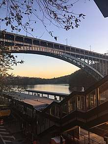
Spuyten Duyvil is the location of the Spuyten Duyvil train station, which is served by the Hudson Line of the Metro-North Railroad, providing service into Grand Central Terminal and north into Westchester County. Spuyten Duyvil Bridge, a railroad swing bridge that carries Amtrak's Empire Corridor line between New York City and Albany, spans Spuyten Duyvil Creek. The north end of the Henry Hudson Bridge connects the neighborhood to the island of Manhattan via the Henry Hudson Parkway.
Points of interest
- Edgehill Church of Spuyten Duyvil (United Church of Christ) was built in 1888-89 as a chapel of the Riverdale Presbyterian Church located nearby, and was designed by Francis H. Kimball in an eclectic mix of styles: Romanesque Revival, Tudor Revival and Shingle style. The church was designated a New York City landmark in 1980.[4][23]
- Henry Hudson Memorial Park features a 16-foot (4.9 m) bronze statue of Henry Hudson sculpted by Karl Bitter and Karl Gruppe on top of a 100-foot (30 m) Doric column by architect Walter Cook of the firm of Babb, Cook & Willard.[3][4]
- Villa Charlotte Bronte is an apartment house built in 1926 and designed by Robert Gardner, which overlooks the Hudson and Harlem Rivers.[4]
See also
- Hell Gate
- List of place names of Dutch origin
- John Jay McKelvey, Sr., Attorney, Park District Protection League Trustee.
References
Notes
- "NYC Planning | Community Profiles". communityprofiles.planning.nyc.gov. New York City Department of City Planning. Retrieved 6 June 2018.
- "Spuyten Duyvil neighborhood in New York". Retrieved 24 November 2015.
- Wolfe, Gerald R. "Spuyten Duyvil neighborhood" in Jackson 1995, p. 1224
- White, Willensky & Leadon 2010, p. 868
- Sixteenth Annual Report, 1911, of the American Secneic and Historic Preservation Society to the Legislature of the State of New York , p. 106. American Scenic and Historic Preservation Society, 1911. Accessed November 4, 2015. "Another reason is that there are phonetic elements in the name as first written which suggest other meanings quite appropriate to the locality. There is a Dutch word 'spui' of frequent use in Holland, meaning a sluice way or canal. The Spui at The Hague, part of which is redeemed and used as a street, is a famous thoroughfare."
- "Inwood Hill Park: Spuyten Duyvil Creek". New York City Department of Parks and Recreation. Retrieved 2 January 2017.
- McDonald, Rabecca (April 29, 2010). "History of the Name Spuyten Duyvil". New York Public Library. Retrieved 2 January 2017.
- Sypher, Frank J. "Dispute Springs Eternal Over 'Spuyten Duyvil'" (letter to the editor) The New York Times (November 14, 1993)
- Ed Boland Jr. (October 13, 2002). "F.Y.I. – Beating the Devil". The New York Times.
- Baumstone, Hal (January 28, 1988). "Stanford News: Legend or History". Pine Plains Register Herald. Fultonhistory.com. p. 8. Retrieved 2 January 2017.
- Fernicola 2001, pp. 104–105.
- Burrows & Wallace 1999, p. 100.
- Burrows & Wallace 1999, p. 944.
- "Railroad Accident Brief: Metro-North Railroad Derailment" (PDF). National Transportation Safety Board. October 24, 2014. Retrieved May 24, 2015.
- Barron, James; Goodman, J. David (2013-12-01). "Focus Turns to Investigation in Fatal Bronx Train Crash". The New York Times. Retrieved 2017-01-02.
- "Attorney: Metro-North train engineer was 'in a daze'". ABC7 New York. 2013-12-04. Retrieved 2017-01-02.
- Table PL-P5 NTA: Total Population and Persons Per Acre - New York City Neighborhood Tabulation Areas*, 2010, Population Division - New York City Department of City Planning, February 2012. Accessed June 16, 2016.
- Table PL-P3A NTA: Total Population by Mutually Exclusive Race and Hispanic Origin - New York City Neighborhood Tabulation Areas*, 2010, Population Division - New York City Department of City Planning, March 29, 2011. Accessed June 14, 2016.
- "NYPD – 50th Precinct". www.nyc.gov. New York City Police Department. Retrieved October 3, 2016.
- "Riverdale: Marble Hill, Fieldston, Spuyten Duyvil, Kingsbridge – DNAinfo.com Crime and Safety Report". www.dnainfo.com. Retrieved October 6, 2016.
- "50th Precinct CompStat Report" (PDF). www.nyc.gov. New York City Police Department. Retrieved July 22, 2018.
- "About the Spuyten Duyvil Library". The New York Public Library. Retrieved March 14, 2019.
- New York City Landmarks Preservation Commission, Dolkart & Postal 2009, p. 346
Bibliography
- Burrows, Edwin G. & Wallace, Mike (1999). Gotham: A History of New York City to 1898. New York: Oxford University Press. ISBN 0-195-11634-8.CS1 maint: ref=harv (link)
- Fernicola, Richard G. (2001). Twelve Days of Terror: A Definitive Investigation of the 1916 New Jersey Shark Attacks. Guilford, CT: Lyons Press. ISBN 978-1-58574-575-3. Retrieved 20 August 2011.CS1 maint: ref=harv (link)
- Jackson, Kenneth T., ed. (1995). The Encyclopedia of New York City. New Haven: Yale University Press. ISBN 0300055366.CS1 maint: ref=harv (link)
- New York City Landmarks Preservation Commission; Dolkart, Andrew S.; Postal, Matthew A. (2009). Postal, Matthew A. (ed.). Guide to New York City Landmarks (4th ed.). New York: John Wiley & Sons. ISBN 978-0-470-28963-1.CS1 maint: ref=harv (link)
- White, Norval; Willensky, Elliot & Leadon, Fran (2010). AIA Guide to New York City (5th ed.). New York: Oxford University Press. ISBN 978-0-19538-386-7.CS1 maint: ref=harv (link)
External links

| South Bronx |  | |
|---|---|---|
| West Bronx | ||
| East Bronx | ||
| Related areas |
| |