Spremberg
Spremberg (Lower Sorbian: Grodk) is a municipality near the Saxon city of Hoyerswerda and is in the Spree-Neiße district of Brandenburg, Germany.
Spremberg/Grodk | |
|---|---|
 Market square | |
 Flag  Coat of arms | |
Location of Spremberg/Grodk within Spree-Neiße district  | |
 Spremberg/Grodk 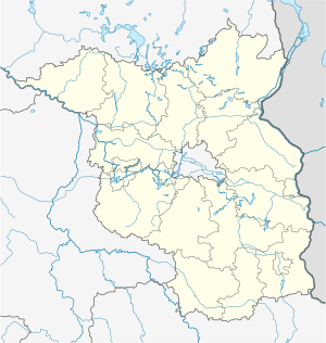 Spremberg/Grodk | |
| Coordinates: 51°34′18″N 14°22′46″E | |
| Country | Germany |
| State | Brandenburg |
| District | Spree-Neiße |
| Government | |
| • Mayor | Christine Herntier (Ind.) |
| Area | |
| • Total | 202.31 km2 (78.11 sq mi) |
| Elevation | 97 m (318 ft) |
| Population (2018-12-31)[1] | |
| • Total | 22,175 |
| • Density | 110/km2 (280/sq mi) |
| Time zone | CET/CEST (UTC+1/+2) |
| Postal codes | 03130 |
| Dialling codes | 03563 |
| Vehicle registration | SPN, FOR, GUB, SPB |
| Website | www.stadt-spremberg.de |
First mentioned in 1301, the town alone has 14,028 inhabitants, and the municipality, including other villages, has 22,456 inhabitants, as of December 31, 2017.
Geography
Spremberg is situated about 20 km south of Cottbus and 25 km north of Hoyerswerda, on an island and on both banks of the river Spree. Between 1871 and 1918 the town was the geographical centre of the German Empire: today, it is only 25 km from the German-Polish border. On 1 January 2016, the former municipality Hornow-Wadelsdorf became part of Spremberg.
Demography
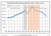 Development of population since 1875 within the current Boundaries (Blue Line: Population; Dotted Line: Comparison to Population development in Brandenburg state; Grey Background: Time of Nazi Germany; Red Background: Time of communist East Germany)
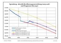 Recent Population Development and Projections (Population Development before Census 2011 (blue line); Recent Population Development according to the Census in Germany in 2011 (blue bordered line); Official projections for 2005-2030 (yellow line); for 2014-2030 (red line); for 2017-2030 (scarlet line)
| Spremberg: Population development within the current boundaries (2017)[2] | |||||||||||||||||||||||||||||||||||||||||||||||||||||||||||||||||||||||||||||||||||||||||||||||||||||||||||||||||||||||||||||||||||||||||
|---|---|---|---|---|---|---|---|---|---|---|---|---|---|---|---|---|---|---|---|---|---|---|---|---|---|---|---|---|---|---|---|---|---|---|---|---|---|---|---|---|---|---|---|---|---|---|---|---|---|---|---|---|---|---|---|---|---|---|---|---|---|---|---|---|---|---|---|---|---|---|---|---|---|---|---|---|---|---|---|---|---|---|---|---|---|---|---|---|---|---|---|---|---|---|---|---|---|---|---|---|---|---|---|---|---|---|---|---|---|---|---|---|---|---|---|---|---|---|---|---|---|---|---|---|---|---|---|---|---|---|---|---|---|---|---|---|---|
|
|
| |||||||||||||||||||||||||||||||||||||||||||||||||||||||||||||||||||||||||||||||||||||||||||||||||||||||||||||||||||||||||||||||||||||||
Mayors
- Friedrich Nath (1908–1919)
- Paul Steffen (1920–1931)
- Richard Buder (1931–1933)
- Kurt Kaulbars (1933–1945) NSDAP
- Rudolf Otto (1944–1945) temporary
- August Scholta (1945–1945) temporary
- Richard Buder (1945–1946)
- Willi Lange (1946–1953)
- Ruth Kartschall (1953–1961)
- Herbert Köhler (1961–1965)
- Günter Frenzel (1965–1975)
- Lothar Barnowski (1975–1975) temporary
- Hannelore Neumann (1975–1990) SED
- Egon Wochatz (1990–2002) CDU
- Klaus-Peter Schulze (2002–2013) CDU
- Christine Schönherr (2013–2013) temporary, independent
- Frank Kulik (2014–2014) temporary, independent
- Christine Herntier (since 2014), independent
Culture
In 1911 there were Roman Catholic and two Protestant churches and a pilgrimage chapel dating from 1100, there was a ducal chateau built by a son of the elector John George around the end of the 16th century (now used as government offices), and there were classical, technical and commercial schools as well as a hospital.
Schwarze Pumpe
Schwarze Pumpe (Lower Sorbian: Carna Plumpa) is a district of Spremberg, lying approximately 7 km southwest of Spremberg's town centre on the federal state boundary between Brandenburg to Saxony. It had 1886 inhabitants as of 31 December 2017. A large industrial area extending into Saxony and including the site of a large power plant is known by the same name.
On 26 May 2006, construction work started on the world's first CO
2-free coal power plant in the Schwarze Pumpe industrial district. The plant is based on a concept called carbon capture and storage, which means that carbon emissions will be captured and compressed to 1⁄500th their original volume, liquefying the gas. It will then be forced 1,000 metres (3,300 ft) below the soil into porous rock where it is believed that it will remain for thousands of years without exacerbating global warming. The project, which has cost some 70 million Euros, was funded entirely by the Swedish company Vattenfall AB and went into service on 9 September 2008. The power plant was a pilot project to serve as a prototype for future full-scale power plants.[3] Vattenfall stopped carbon capture R&D at the plant in 2014 because they found that "its costs and the energy it requires make the technology unviable".[4]
Sons and daughters of the town
- Johann Agricola (1530-1590), Protestant theologian of the 16th century
- Otto Ostrowski (1883-1963), politician (SPD), Lord Mayor of Berlin 1946/1947
- Erwin Strittmatter (1912-1994), writer
- Joachim Teege (1925-1969), actor and cabaret artist
- Dirk Meier (born 1964), cyclist
- Sebastian Piersig (born 1984), slalom-canoeist, participant Olympia 2008 in Beijing
References
- "Bevölkerung im Land Brandenburg nach amtsfreien Gemeinden, Ämtern und Gemeinden 31. Dezember 2018". Amt für Statistik Berlin-Brandenburg (in German). July 2019.
- Detailed data sources are to be found in the Wikimedia Commons.Population Projection Brandenburg at Wikimedia Commons
- Germany leads 'clean coal' pilot, BBC News, 2008-09-03
- "Vattenfall abandons research on CO2 storage". The Local. 7 May 2014.
External links

- . Encyclopædia Britannica. 25 (11th ed.). 1911.
| Authority control |
|
|---|