Spooner, Wisconsin
Spooner is a city in Washburn County, Wisconsin, United States. The population was 2,682 at the 2010 census. The city is located mostly within the southwest corner of the Town of Spooner, with a small portion extending into the Town of Beaver Brook on the south, the Town of Bashaw on the southwest, and the Town of Evergreen on the west. The city's nickname, Crossroads of the North, is a reference to the city's location at the junction of two U.S. highways, 53 and 63, and State Highways 70 and 253.
Spooner | |
|---|---|
City | |
 Downtown Spooner | |
| Nickname(s): Crossroads of the North | |
 Location of Spooner in Washburn County, Wisconsin. | |
 Spooner Location within the state of Wisconsin | |
| Coordinates: 45°49′33″N 91°53′28″W | |
| Country | United States |
| State | Wisconsin |
| County | Washburn |
| Area | |
| • Total | 4.27 sq mi (11.06 km2) |
| • Land | 4.03 sq mi (10.45 km2) |
| • Water | 0.24 sq mi (0.61 km2) |
| Population | |
| • Total | 2,682 |
| • Estimate (2018)[3] | 2,609 |
| • Density | 646.75/sq mi (249.71/km2) |
| Time zone | UTC-6 (Central (CST)) |
| • Summer (DST) | UTC-5 (CDT) |
| Area code(s) | 715 & 534 |
| FIPS code | 55-75625 |
| Website | Official website |
History
Originally a town in the year 1889, and thereafter officially incorporated a city in the year 1909, Spooner's history is closely interlaced with that of railroad history. In the year 1879, the North Wisconsin Railway was constructed due north of the present-day city of Spooner. Following that, the operations of that railroad were moved south where it then joined the Chicago and Northwestern at what was then coined as Chicago Junction.[4][5]
The community, then initially only a station, was named by the general superintendent for the Chicago and Northwestern, Edwin W. Winter, for John Coit Spooner (1843 - 1919), who at the time was a distinguished railroad attorney from what is now the city of Hudson in St. Croix County, northwestern Wisconsin. Spooner would later serve in the Wisconsin State Assembly and represent Wisconsin in the United States Senate (1885-1891, 1897-1907). He was a well favoured politician of his time and even served as advisors to U.S. Presidents Benjamin Harrison, William McKinley, and Theodore Roosevelt.[6][4][5]
Eventually, the lines were absorbed by the Chicago & North Western Railroad. Passenger service ended in the early 1960s under the CNW ownership. In 1992, the Wisconsin Great Northern Railroad was incorporated, to serve as a freight hauler from Spooner to Trego, a nearby town, with a connection to the CNW. Although the freight idea didn't work out, they began operating successful passenger excursion trains in 1997 (following the example of the nearby Duluth & Northern Minnesota Railroad which began passenger excursions in Duluth only a few years before), and were an instant success. The passenger trains were very successful, and after the 1995 takeover of the CNW by the Union Pacific, UP in 1998 announced intentions to abandon the line from Hayward Junction where it connected to the Wisconsin Central 13 miles (21 km) to the north through Spooner all of the way down to Chippewa Falls. The company bought the portion of the line between Spooner and Hayward Jct in 1999, which greatly expanded passenger operations. To this day they run very popular robbery, western style, cowboy, and buffet style as well as more formal dinner trains. More recently, the Great Pumpkin train nearly sold out and now runs annually around the time of Halloween.[7][8][9] The old CNW Spooner Railroad Depot now serves as the town's Railroad Memories Museum.
The city was also once the hub of the Omaha Railroad Line. Its economy was once centered on the railroad and the two main lines that joined there.
Geography
Spooner is located at 45°49′33″N 91°53′28″W (45.825941, -91.891116).[10]
According to the United States Census Bureau, the city has a total area of 3.52 square miles (9.12 km2), of which, 3.29 square miles (8.52 km2) is land and 0.23 square miles (0.60 km2) is water.[11]
Climate
Spooner has a Humid continental climate (Köppen climate classification Dfb), typical of northern Wisconsin with warm, humid summers and relatively long, cold winters.
| Climate data for Spooner, Wisconsin (1981–2010) | |||||||||||||
|---|---|---|---|---|---|---|---|---|---|---|---|---|---|
| Month | Jan | Feb | Mar | Apr | May | Jun | Jul | Aug | Sep | Oct | Nov | Dec | Year |
| Record high °F (°C) | 57 (14) |
61 (16) |
81 (27) |
90 (32) |
104 (40) |
100 (38) |
110 (43) |
104 (40) |
99 (37) |
88 (31) |
74 (23) |
60 (16) |
110 (43) |
| Average high °F (°C) | 21.0 (−6.1) |
27.3 (−2.6) |
39.8 (4.3) |
55.8 (13.2) |
67.7 (19.8) |
76.4 (24.7) |
80.5 (26.9) |
78.3 (25.7) |
69.0 (20.6) |
56.2 (13.4) |
38.7 (3.7) |
24.0 (−4.4) |
52.9 (11.6) |
| Average low °F (°C) | 0.5 (−17.5) |
5.5 (−14.7) |
18.7 (−7.4) |
32.2 (0.1) |
43.7 (6.5) |
53.5 (11.9) |
58.1 (14.5) |
56.2 (13.4) |
47.6 (8.7) |
36.0 (2.2) |
22.8 (−5.1) |
7.0 (−13.9) |
31.8 (−0.1) |
| Record low °F (°C) | −45 (−43) |
−46 (−43) |
−38 (−39) |
−7 (−22) |
13 (−11) |
22 (−6) |
35 (2) |
29 (−2) |
18 (−8) |
2 (−17) |
−26 (−32) |
−44 (−42) |
−46 (−43) |
| Average precipitation inches (mm) | 0.73 (19) |
0.73 (19) |
1.39 (35) |
2.59 (66) |
3.48 (88) |
4.04 (103) |
4.09 (104) |
4.18 (106) |
3.80 (97) |
3.14 (80) |
1.69 (43) |
0.98 (25) |
30.76 (781) |
| Average snowfall inches (cm) | 11.0 (28) |
8.5 (22) |
8.9 (23) |
2.7 (6.9) |
0.1 (0.25) |
0 (0) |
0 (0) |
0 (0) |
0 (0) |
1.0 (2.5) |
7.5 (19) |
12.1 (31) |
51.3 (130) |
| Average precipitation days (≥ 0.01 in) | 8 | 6 | 7 | 9 | 12 | 12 | 10 | 10 | 11 | 11 | 8 | 9 | 111 |
| Average snowy days (≥ 0.1 in) | 7 | 6 | 4 | 1 | 0 | 0 | 0 | 0 | 0 | 1 | 4 | 8 | 31 |
| Source: NOAA (extremes 1894–present)[12] | |||||||||||||
Demographics
| Historical population | |||
|---|---|---|---|
| Census | Pop. | %± | |
| 1910 | 1,453 | — | |
| 1920 | 2,293 | 57.8% | |
| 1930 | 2,426 | 5.8% | |
| 1940 | 2,639 | 8.8% | |
| 1950 | 2,597 | −1.6% | |
| 1960 | 2,398 | −7.7% | |
| 1970 | 2,444 | 1.9% | |
| 1980 | 2,365 | −3.2% | |
| 1990 | 2,464 | 4.2% | |
| 2000 | 2,653 | 7.7% | |
| 2010 | 2,682 | 1.1% | |
| Est. 2018 | 2,609 | [3] | −2.7% |
| U.S. Decennial Census[13] | |||
2010 census
As of the census[2] of 2010, there were 2,682 people, 1,180 households, and 666 families residing in the city. The population density was 815.2 inhabitants per square mile (314.8/km2). There were 1,302 housing units at an average density of 395.7 per square mile (152.8/km2). The racial makeup of the city was 95.1% White, 0.3% African American, 1.9% Native American, 0.7% Asian, 0.1% from other races, and 1.9% from two or more races. Hispanic or Latino of any race were 1.3% of the population.
There were 1,180 households of which 28.9% had children under the age of 18 living with them, 37.2% were married couples living together, 13.5% had a female householder with no husband present, 5.8% had a male householder with no wife present, and 43.6% were non-families. 38.1% of all households were made up of individuals and 18.3% had someone living alone who was 65 years of age or older. The average household size was 2.18 and the average family size was 2.84.
The median age in the city was 41.6 years. 23.9% of residents were under the age of 18; 7.8% were between the ages of 18 and 24; 21.5% were from 25 to 44; 25.3% were from 45 to 64; and 21.5% were 65 years of age or older. The gender makeup of the city was 45.6% male and 54.4% female.
2000 census
As of the census[14] of 2000, there were 2,653 people, 1,148 households, and 662 families residing in the city. The population density was 875.9 people per square mile (338.1/km²). There were 1,249 housing units at an average density of 412.4 per square mile (159.2/km²). The racial makeup of the city was 95.97% White, 0.41% Black or African American, 2.04% Native American, 0.04% Asian, 0.38% from other races, and 1.17% from two or more races. 1.21% of the population were Hispanic or Latino of any race.
There were 1,148 households out of which 27.4% had children under the age of 18 living with them, 42.4% were married couples living together, 11.1% had a female householder with no husband present, and 42.3% were non-families. 37.8% of all households were made up of individuals and 20.4% had someone living alone who was 65 years of age or older. The average household size was 2.22 and the average family size was 2.90.
In the city, the population was spread out with 24.0% under the age of 18, 7.2% from 18 to 24, 24.3% from 25 to 44, 21.7% from 45 to 64, and 22.8% who were 65 years of age or older. The median age was 41 years. For every 100 females, there were 85.9 males. For every 100 females age 18 and over, there were 77.8 males.
The median income for a household in the city was $27,768, and the median income for a family was $39,677. The median income of its residents was $16,390. About 7.6% of families and 11.9% of the population were below the poverty line, including 12.7% of those under age 18 and 10.5% of those age 65 or over.
Attractions
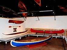
The Wisconsin Canoe Heritage Museum,[15] a museum dedicated to the preservation and interpretation of the cultural heritage of canoes and canoeing in North America, has displays of canoes and canoe-related ephemera.
Since 1954, each summer in July, Spooner has hosted the Heart of the North Rodeo, which draws thousands of fans to the area. In addition to the rodeo each evening, there is a Saturday afternoon parade, live music every night, and the cowboy church service on Sunday morning, held outdoors at the rodeo arena.
The Jack Pine Savage Days is a local festival that features live bands, an annual fun run, a 3 on 3 basketball tournament, a horseshoe tournament, and a volleyball tournament.[16]
Jack O' Lantern Fest is an October festival that revolves around giving back to kids and families. Multiple inflatables, fundraising walk, pumpkin roll, pet costume contest, carnival games, baking contest, pumpkin carving contest and more.[17]
Notable people
- Guy Benson, mayor and legislator
- Frank Hammill, farmer, mayor, and legislator[18]
- Travis Randall, actor, musician, and director
- Holger Rasmusen, mayor and legislator[19]
References
- "2018 U.S. Gazetteer Files". United States Census Bureau. Retrieved Feb 15, 2020.
- "U.S. Census website". United States Census Bureau. Retrieved 2012-11-18.
- "Population and Housing Unit Estimates". Retrieved June 4, 2019.
- Callary, Edward (2016). Place Names of Wisconsin. Madison, Wisconsin: University of Wisconsin Press. ISBN 9780299309640.
- Stennett, W.H. (1908). History of the Origin of the Place Names Connected with the Chicago & North Western and Chicago, St. Paul, Minneapolis & Omaha Railways. Chicago, Illinois. p. 192.
- Chicago and North Western Railway Company (1908). A History of the Origin of the Place Names Connected with the Chicago & North Western and Chicago, St. Paul, Minneapolis & Omaha Railways. p. 192.
- "The Story of the Wisconsin Great Northern Railroad". Archived from the original on November 28, 2010. Retrieved November 9, 2010.
- "History of the Line". Archived from the original on November 28, 2010. Retrieved November 9, 2010.
- http://spoonertrainride.com/
- "US Gazetteer files: 2010, 2000, and 1990". United States Census Bureau. 2011-02-12. Retrieved 2011-04-23.
- "US Gazetteer files 2010". United States Census Bureau. Archived from the original on January 24, 2012. Retrieved 2012-11-18.
- "NOWData - NOAA Online Weather Data". National Oceanic and Atmospheric Administration. Retrieved May 29, 2016.
- "Census of Population and Housing". Census.gov. Retrieved June 4, 2015.
- "U.S. Census website". United States Census Bureau. Retrieved 2008-01-31.
- Wisconsin Canoe Heritage Museum
- Jack Pine Savage Days website
- Jack O' Lantern Fest website
- 'Wisconsin Blue Book 1909,' Biographical Sketch of Frank Hammill, pg. 1108
- 'Wisconsin Blue Book 1970,' Biographical Sketch of Holger Rasmusen, pg. 29
External links
- Spooner, Wisconsin
- Spooner Area Chamber of Commerce
- Sanborn fire insurance maps: 1909 1917
Municipalities and communities of Washburn County, Wisconsin, United States | ||
|---|---|---|
| Cities |  | |
| Villages | ||
| Towns | ||
| CDPs | ||
| Unincorporated communities | ||
| Ghost town/neighborhood | ||
| Indian reservation | ||
| Footnotes | ‡This populated place also has portions in an adjacent county or counties | |