Southern Hudson Bay taiga
The Southern Hudson Bay taiga is a terrestrial ecoregion, as classified by the World Wildlife Fund, which extends along the southern coast of Hudson Bay and resides within the larger taiga biome. Entirely located in Canada, it covers an area of approximately 373,735 km2 and crosses the provinces of Manitoba, Ontario, and the western portion of Quebec.[2] Various islands in James Bay which belong to the Northwest Territories are also considered to be part of the ecoregion.
| Southern Hudson Bay taiga | |
|---|---|
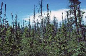 Black Spruce (Picea mariana) forest typical of the taiga biome | |
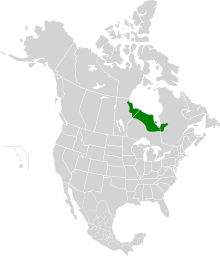 Extent of the Southern Hudson Bay taiga ecoregion | |
| Ecology | |
| Realm | Nearctic |
| Biome | Taiga |
| Borders | Eastern Canadian Shield taiga, Northern Canadian Shield taiga, Central Canadian Shield forests and Midwestern Canadian Shield forests |
| Bird species | 160 |
| Mammal species | 45 |
| Geography | |
| Area | 373,735 km2 (144,300 sq mi) |
| Country | Canada |
| Province | Ontario, Manitoba, Quebec and Northwest Territories |
| Elevation | 120 m asl |
| Coordinates | 53.943°N 85.390°W |
| Oceans or seas | Arctic Ocean |
| Climate type | Subarctic and Boreal |
| Conservation | |
| Conservation status | Relatively Stable/Intact |
| Global 200 | No |
| Habitat loss | 1%[1] |
| Protected | 9.32%[1] |
Setting
The Southern Hudson Bay taiga is contained within the conceptually larger Nearctic ecozone and possesses a number of neighbouring ecoregions including the Eastern Canadian Shield taiga, Northern Canadian Shield taiga, Central Canadian Shield forests, and Midwestern Canadian Shield forests. Prominent geological features in the region include the Hudson Platform and an underlying layer of Paleozoic limestone bedrock.[1] Its soils, which are primarily Gelic and Dystric Histosols and Eutric Gleysols, are characterized by shallow layers of permafrost, slightly acidic pH levels, and hydromorphic conditions.[3] The Southern Hudson Bay taiga represents an area where a number of hydrologically significant rivers, such as the Nelson River and the Mattagami River, deposit their headwaters from farther inland into the Arctic Ocean via Hudson Bay.[4] Alternative geographic classifications also commonly refer to the region as the Hudson Bay Lowlands.
Climate
Classified as a subarctic climate under the Köppen-Geiger climate classification system, typical seasonal conditions in the Southern Hudson Bay taiga consist of brief, cool summers and cold winters.[5] Average temperatures range from 10.5°C to 11.5°C during summer months, -19°C to -16°C during winter months, and -5°C to -2°C throughout the year. Precipitation levels vary greatly within the region due to differences in temperature, with the eastern and western areas receiving an annual average of 500-800 mm and the northern areas as little as 400 mm.[1]
Flora
Belonging to the circumboreal floristic region, the Southern Hudson Bay taiga contains a total of 1178 different plant species – none of which are considered endemic to the area.[6] The major plant communities in this ecoregion, which are characteristic of the taiga biome, primarily consist of black spruce (Picea mariana) and tamarack (Larix laricina) forests. Species which commonly dominate the forest undergrowth are birch (Betula), willow (Salix), and marsh Labrador tea (Rhododendron tomentosum). Due to the tundra conditions in the northern extent of the region, a latitudinal gradient of plant biodiversity exists which increases towards the south. Wetlands in this ecoregion are estimated to occupy between 50 and 75% of the land area.[1]
Fauna
In terms of species composition, the animal populations of the Southern Hudson Bay taiga are largely transitional between those of the Central Canadian Shield forests and Low Arctic tundra. The region contains a total of 45 mammal species, 160 bird species, and 2 reptile species.[6] The coastal areas of southern Hudson Bay are home to polar bears (Ursus marinus), arctic foxes (Vulpes lagopus), seals (Phocidae), beluga whales (Delphinapterus leucas), and tundra swans (Cygnus columbianus). Approaching the Central Canadian Shield forests near James Bay, the ecoregion gives way to moose (Alces), black bears (Ursus americanus), wolves (Canis lupus), and Canada lynx (Lynx canadensis). Other species which can be found throughout the entirety of the ecoregion are caribou (Rangifer tarandus), snowshoe hare (Lepus americanus), and Canada goose (Branta canadensis).[1]
Human use
With an average population density estimated at less than 1 person/km2, the majority of the human population in the Southern Hudson Bay taiga is concentrated in a number of smaller towns and communities located along the southern coast of Hudson Bay.[6] These include Churchill, Moosonee, and Moose Factory as well as the First Nation communities of Fort Severn, Fort Albany, and Attawapiskat. Much of the ecoregion is the traditional territory of the Cree, Dene, Inuit, and Métis peoples.[7] The region also witnessed the development of the Hudson's Bay Company during the 17th century and played an integral role in the North American fur trade. It was part of a larger area referred to as Rupert's Land in which the Hudson's Bay Company had exclusive commercial rights until it was sold to the Canadian government in 1870.[8]
Conservation and threats
The World Wildlife Fund has classified the conservation status of the ecoregion as relatively stable/intact as a result of its sparse, low-impact human presence. It is therefore not part of the WWF's Global 200 list of ecoregions most in need of conservation efforts. Approximately 9.32% of all lands in the Southern Hudson Bay taiga are considered protected including Polar Bear Provincial Park, Wapusk National Park, and Jog Lake Conservation Reserve. As a result of its more northern latitude, the area is not subject to intense logging or deforestation pressures. The primary conservation concerns for the region surround the proposed hydroelectric projects near James Bay and the regulation of hunt camps.[1] Estimates indicate that the Southern Hudson Bay taiga will experience an increase in temperature of 3.39°C and an increase in precipitation of 13.32 mm by 2050 as a result of climate change.[6]
References
- "Southern Hudson Bay taiga | Ecoregions | WWF". World Wildlife Fund. Retrieved 2019-04-02.
- Olson, D. M, E. Dinerstein; et al. (2001). "Terrestrial Ecoregions of the World: A New Map of Life on Earth". BioScience. 51 (11): 933–938. doi:10.1641/0006-3568(2001)051[0933:TEOTWA]2.0.CO;2.CS1 maint: multiple names: authors list (link)
- "FAO/UNESCO Soil Map of the World | FAO SOILS PORTAL | Food and Agriculture Organization of the United Nations". www.fao.org. Retrieved 2019-04-02.
- Canada, Natural Resources (2013-10-07). "The Atlas of Canada". www.nrcan.gc.ca. Retrieved 2019-04-02.
- Wood, Eric F.; Berg, Alexis; Noemi Vergopolan; McVicar, Tim R.; Zimmermann, Niklaus E.; Beck, Hylke E. (2018-10-30). "Present and future Köppen-Geiger climate classification maps at 1-km resolution". Scientific Data. 5: 180214. doi:10.1038/sdata.2018.214. PMC 6207062. PMID 30375988.
- "The Atlas of Global Conservation". maps.tnc.org. Retrieved 2019-04-03.
- "NativeLand.ca". Native-land.ca - Our home on native land. Retrieved 2019-04-05.
- "Hudson's Bay Company | The Canadian Encyclopedia". www.thecanadianencyclopedia.ca. Retrieved 2019-04-05.