South Fork New River
The South Fork New River is a river in the U.S. state of North Carolina.
| South Fork New River | |
|---|---|
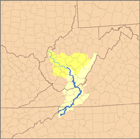 Map of the Kanawha River watershed, with the New River and its watershed highlighted. | |
| Location | |
| Country | United States |
| State | North Carolina |
| Counties | Watauga, Alleghany, Ashe |
| Physical characteristics | |
| Source | Middle Fork South Fork New River |
| ⁃ location | Blowing Rock, NC |
| ⁃ coordinates | 36°07′34″N 81°40′20″W |
| ⁃ elevation | 3,543 ft (1,080 m) |
| 2nd source | East Fork South Fork New River |
| ⁃ location | Watauga County, NC |
| ⁃ coordinates | 36°10′56″N 81°36′37″W |
| ⁃ elevation | 3,271 ft (997 m) |
| Source confluence | |
| ⁃ location | Boone, NC |
| ⁃ coordinates | 36°12′16″N 81°38′59″W |
| ⁃ elevation | 3,104 ft (946 m) |
| Mouth | New River[1] |
⁃ location | Ashe County, NC |
⁃ coordinates | 36°32′46″N 81°21′11″W |
⁃ elevation | 2,546 ft (776 m) |
| Discharge | |
| ⁃ location | Jefferson, NC[2] |
| ⁃ average | 552 cu ft/s (15.6 m3/s) |
| ⁃ minimum | 227 cu ft/s (6.4 m3/s)(1986) |
| ⁃ maximum | 2,120 cu ft/s (60 m3/s)(1998) |
It stretches from its headwaters at a spring near Blowing Rock and the Eastern Continental Divide and meanders northward along the northwestern face of the Blue Ridge Mountains through the eastern and central portions of Watauga County and then Ashe County in northwestern North Carolina, passing through the town of Boone. It joins the North Fork New River in Ashe County to form the New River. Its waters ultimately reach the Gulf of Mexico through the Kanawha River, the Ohio River, and the Mississippi River. Its tributaries include Winkler's Creek, Boone (Kraut) Creek and Payne Branch.
See also
- New River
- North Fork New River
References
This article is issued from Wikipedia. The text is licensed under Creative Commons - Attribution - Sharealike. Additional terms may apply for the media files.