South Carolina Highway 652
South Carolina Highway 652 (SC 652) is a 10.5-mile-long (16.9 km) state highway in the U.S. state of South Carolina. The highway travels through rural areas of Jasper County. It is known as Calf Pen Bay Road for its entire length.
| ||||
|---|---|---|---|---|
| Calf Pen Bay Road | ||||
| ||||
| Route information | ||||
| Maintained by SCDOT | ||||
| Length | 10.48 mi[1] (16.87 km) | |||
| Major junctions | ||||
| West end | ||||
| East end | ||||
| Location | ||||
| Counties | Jasper | |||
| Highway system | ||||
| ||||

Route description
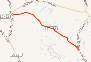
SC 652 begins at an intersection with U.S. Route 601 (US 601; Cypress Branch Road) north-northwest of Tarboro, Jasper County. It travels to the east-northeast and curves to the southeast until it meets its eastern terminus, an intersection with US 278 (Grays Highway) at a point north-northwest of Ridgeland.[2]
Major intersections
The entire route is in Jasper County.
| Location | mi[2] | km | Destinations | Notes | |
|---|---|---|---|---|---|
| | 0.00 | 0.00 | |||
| | 10.48 | 16.87 | |||
| 1.000 mi = 1.609 km; 1.000 km = 0.621 mi | |||||
See also


References
- "Statewide Highways (shapefile)" (zip). South Carolina Department of Transportation. September 29, 2017. Retrieved December 8, 2017.
- Google (May 17, 2016). "South Carolina Highway 652" (Map). Google Maps. Google. Retrieved May 17, 2016.
External links

- SC 652 South Carolina Hwy Index
This article is issued from Wikipedia. The text is licensed under Creative Commons - Attribution - Sharealike. Additional terms may apply for the media files.