South Carolina Highway 19
South Carolina Highway 19 (SC 19) is a primary state highway in the U.S. state of South Carolina. It connects Aiken directly with the Savannah River Site and Edgefield via U.S. Route 25 (US 25).
| ||||
|---|---|---|---|---|
 | ||||
| Route information | ||||
| Maintained by SCDOT | ||||
| Length | 28.8 mi[1] (46.3 km) | |||
| Existed | 1922–present | |||
| Major junctions | ||||
| South end | Savannah River Site | |||
| ||||
| North end | ||||
| Location | ||||
| Counties | Aiken, Edgefield | |||
| Highway system | ||||
| ||||

Route description
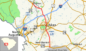
SC 19 operates as arterial four-lane highway from Aiken to the Savannah River Site; to its north, it is a two-lane rural highway to Trenton, where it connects with US 25 and SC 121. In Aiken's downtown area, SC 19 is signed, northbound along Chesterfield Street and Richland Avenue (on state maps, it is officially SC 19 Connector); while SC 19 southbound travels along Laurens Street/Park Avenue onto Chesterfield Street.
History
SC 19 is an original state highway, established in 1922. Its original routing was from SC 2 in Newberry, north through Whitmire, Union, Spartanburg, Inman and Landrum, to the North Carolina state line continuing as NC 19. In 1923, it was extended south on new primary routing, through Saluda, to SC 21/SC 27 in Trenton. In 1927, US 176 was assigned to SC 19 from Newberry to the North Carolina state line; the following year it was removed from the overlap. Also in 1928, SC 19 was extended south, replacing part of SC 27 to US 1/US 78 in Aiken. In 1929 or 1930, SC 19 was extended south (again) to SC 28 north of Ellenton.
Around 1952, the Savannah River Site was established; which removed nine miles (14 km) of highway in what is now a restricted area. By 1955, SC 19 was widened to four-lanes between the Savannah River Site and Aiken.[2][3] In 1964, SC 19 was truncated to its current northern terminus at Trenton; its routing north to Saluda was replaced by SC 121.[4][5][6][7]
Junction list
| County | Location | mi[1] | km | Destinations | Notes |
|---|---|---|---|---|---|
| Aiken | Savannah River Site | 0.0 | 0.0 | SRS Road 1 / SRS Road 2 | Gate entrance .3-mile (0.48 km) south, restricted access |
| New Ellenton | 0.5 | 0.80 | |||
| Aiken | 10.0 | 16.1 | |||
| 12.5 | 20.1 | Signed Northbound SC 19, which also overlaps with US 1/US 78 | |||
| 12.9 | 20.8 | ||||
| 14.2 | 22.9 | ||||
| | 18.6 | 29.9 | |||
| | 19.5 | 31.4 | South end of SC 191 overlap | ||
| Eureka | 22.7 | 36.5 | North end of SC 191 overlap | ||
| Edgefield | Trenton | 27.8 | 44.7 | Unsigned connector routes | |
| 28.8 | 46.3 | ||||
1.000 mi = 1.609 km; 1.000 km = 0.621 mi
| |||||
Special routes
Aiken truck route
| |
|---|---|
| Location | Aiken, South Carolina |
| Length | 9.9 mi[8] (15.9 km) |
South Carolina Highway 19 Truck (SC 19 Truck) provides routing west around downtown Aiken, via SC 118, for trucks; which are not allowed in the downtown area.
Aiken connector
| |
|---|---|
| Location | Aiken, South Carolina |
| Length | 0.19 mi[9] (0.31 km) |
South Carolina Highway 19 Connector (SC 19 Conn) is a short .19 miles (0.31 km) hidden connector route, which is signed as northbound SC 19, between Park Avenue and Richland Avenue. Northbound SC 19 continue northbound along Richland Avenue to reconnect southbound SC 19 at Laurens Avenue.[10]
Trenton connector
| |
|---|---|
| Location | Trenton, South Carolina |
| Length | 2.0 mi[11] (3.2 km) |
South Carolina Highway 19 Connector (SC 19 Conn) is a 2-mile (3.2 km) unsigned connector route through Trenton, via Samuel E. Diggs Road and Wise Street. Sharing a concurrency with SC 121 Conn, it has appeared on official state maps since the 1930s (possibly earlier). The routing provides a primary routing through the center of Trenton.[12]
See also


- Central Savannah River Area
References
- Google (April 14, 2014). "South Carolina Highway 19" (Map). Google Maps. Google. Retrieved April 14, 2014.
- General Highway Map, Aiken County, South Carolina (PDF) (Map). Cartography by SCDOT. South Carolina Department of Transportation. 1940. Retrieved April 14, 2014.
- General Highway Map, Aiken County, South Carolina (PDF) (Map). Cartography by SCDOT. South Carolina Department of Transportation. 1956. Retrieved April 14, 2014.
- General Highway Map, Edgefield County, South Carolina (PDF) (Map). Cartography by SCDOT. South Carolina Department of Transportation. 1962. Retrieved April 14, 2014.
- General Highway Map, Edgefield County, South Carolina (PDF) (Map). Cartography by SCDOT. South Carolina Department of Transportation. 1964. Retrieved April 14, 2014.
- General Highway Map, Saluda County, South Carolina (PDF) (Map). Cartography by SCDOT. South Carolina Department of Transportation. 1963. Retrieved April 14, 2014.
- General Highway Map, Saluda County, South Carolina (PDF) (Map). Cartography by SCDOT. South Carolina Department of Transportation. 1967. Retrieved April 14, 2014.
- Google (April 14, 2014). "South Carolina Highway 19 Truck - Aiken" (Map). Google Maps. Google. Retrieved April 14, 2014.
- Google (April 14, 2014). "South Carolina Highway 19 Connector - Aiken" (Map). Google Maps. Google. Retrieved April 14, 2014.
- Aiken & North Augusta Urban Area, Aiken County (PDF) (Map). South Carolina Department of Transportation. December 2011. Retrieved April 14, 2014.
- Google (April 14, 2014). "South Carolina Highway 19 Connector - Trenton" (Map). Google Maps. Google. Retrieved April 14, 2014.
- Town of Trenton, Edgefield County (PDF) (Map). South Carolina Department of Transportation. September 2009. Retrieved April 14, 2014.
External links

- Mapmikey's South Carolina Highways Page: SC 10-19