Sint Jansteen
Sint Jansteen is a town in the Dutch province of Zeeland. It is a part of the municipality of Hulst, and lies about 31 km southwest of Bergen op Zoom.
Sint Jansteen | |
|---|---|
Town | |
 Coat of arms | |
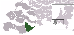 | |
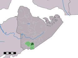 The town centre (dark green) and the statistical district (light green) of Sint Jansteen in the municipality of Hulst. | |
| Coordinates: 51°15′48″N 4°3′4″E | |
| Country | Netherlands |
| Province | Zeeland |
| Municipality | Hulst |
| Population (1 January 2010) | |
| • Total | 3,178 |
| Time zone | UTC+1 (CET) |
| • Summer (DST) | UTC+2 (CEST) |
Sint Jansteen was a separate municipality until 1970, when it was merged with Hulst.[1]
In 2001, the town of Sint Jansteen had 2959 inhabitants. The built-up area of the town was 0.93 km², and contained 1234 residences.[2] The statistical area "Sint Jansteen", which also can include the peripheral parts of the village, as well as the surrounding countryside, has a population of around 3310.[3]
Sint Jansteen was completely demolished on the order of Lt General Pieter de La Rocque, in preparation against the French attack on Hulst during the Austrian Succession War in 1747.[4]
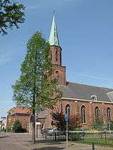
Sint Jansteen, church: de Sint Johannes de Doperkerk
References
- Ad van der Meer and Onno Boonstra, Repertorium van Nederlandse gemeenten, KNAW, 2006.
- Statistics Netherlands (CBS), Bevolkingskernen in Nederland 2001. (Statistics are for the continuous built-up area).
- Statistics Netherlands (CBS), Statline: Kerncijfers wijken en buurten 2003-2005. As of 1 January 2005.
- http://www.lowensteyn.com/Samuel_Holland/hulst.html
External links
- J. Kuyper, Gemeente Atlas van Nederland, 1865-1870, "Sint Jansteen". Map of the former municipality, around 1868.
This article is issued from Wikipedia. The text is licensed under Creative Commons - Attribution - Sharealike. Additional terms may apply for the media files.