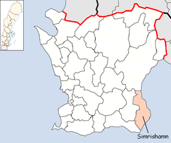
Simrishamn Municipality
Simrishamn Municipality (Swedish: Simrishamns kommun) is a municipality in Skåne County in southern Sweden. Its seat is located in the city Simrishamn.
Simrishamn Municipality Simrishamns kommun | |
|---|---|
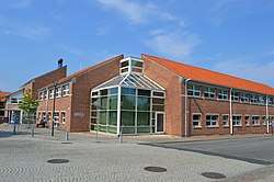 Simrishamn Library | |
 Coat of arms | |
 | |
| Coordinates: 55°33′N 14°21′E | |
| Country | Sweden |
| County | Skåne County |
| Seat | Simrishamn |
| Area | |
| • Total | 1,261.15 km2 (486.93 sq mi) |
| • Land | 391.36 km2 (151.10 sq mi) |
| • Water | 869.79 km2 (335.83 sq mi) |
| Area as of 1 January 2014. | |
| Population (31 December 2019)[2] | |
| • Total | 19,174 |
| • Density | 15/km2 (39/sq mi) |
| Time zone | UTC+01:00 (CET) |
| • Summer (DST) | UTC+02:00 (CEST) |
| ISO 3166 code | SE |
| Province | Scania |
| Municipal code | 1291 |
| Website | www.simrishamn.se |
The creation of the present municipality took place during the last of the two nationwide municipal reforms carried out in Sweden during the second half of the 20th century. In 1969 a number of surrounding rural municipalities were merged with the City of Simrishamn. The enlarged city became a municipality of unitary type in 1971 and in 1974 more territory was added. The number of original entities (pre-1952) is twenty.
Geography
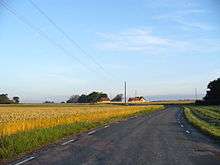
The landscape south and west of Simrishamn is mainly open and very flat farmland, in most places you can see for several miles in all directions. To the north of Simrishamn the landscape is broken up by small forests and gently sloping hills. The coastline directly south and north of Simrishamn is stony to a great degree, but turns into broad beaches with white sand further away. The scenic Stenshuvud National Park is located by the shore, within the municipal borders, and is one of the geographically more fascinating places in Scania. Simrishamn is located in the Österlen area.


Politics
The 2018 municipal election resulted in the following composition of the council:[3]
| Party | Seats | |
|---|---|---|
| Moderate Party | 12 | |
| Social Democratic Party | 11 | |
| Sweden Democrats | 8 | |
| Centre Party | 4 | |
| Liberals | 3 | |
| Feminist Initiative | 3 | |
| Green Party | 2 | |
| Left Party | 2 | |
| Christian Democrats | 2 | |
| Österlen Party | 2 | |
| Total | 49 | |
Localities
There are 13 urban areas (also called tätorter or localities) in Simrishamn Municipality. In the table they are listed according to the size of the population as of December 31, 2005. The municipal seat is in bold characters.
| # | Locality | Population |
|---|---|---|
| 1 | Simrishamn | 6546 |
| 2 | Kivik | 1013 |
| 3 | Skillinge | 1005 |
| 4 | Gärsnäs | 955 |
| 5 | Borrby | 947 |
| 6 | Hammenhög | 908 |
| 7 | Sankt Olof | 640 |
| 8 | Brantevik | 451 |
| 9 | Östra Tommarp | 279 |
| 10 | Vik | 264 |
| 11 | Vitaby | 255 |
| 12 | Baskemölla | 238 |
| 13 | Simris | 235 |
Minor localities
There are 14 minor localities (also called småorter) in Simrishamn Municipality. In the table they are listed according to the size of the population as of December 31, 2005.
| # | Minor locality | Population |
|---|---|---|
| 14 | Östra Vemmerlöv | 194 |
| 15 | Gröstorp | 190 |
| 16 | Järrestad | 170 |
| 17 | Gladsax | 128 |
| 18 | Ravlunda | 111 |
| 19 | Sandby | 105 |
| 20 | Vitemölla | 100 |
| 21 | Södra Mellby | 92 |
| 22 | Örnahusen | 87 |
| 23 | Gyllebo | 69 |
| 24 | Vallby | 67 |
| 25 | Skräddaröd | 58 |
| 26 | Östra Hoby | 55 |
| 27 | Raskarum + Ljunglyckorna* | 54 |
* Counted together
International relations
References
- "Statistiska centralbyrån, Kommunarealer den 1 januari 2014" (in Swedish). Statistics Sweden. 2014-01-01. Archived from the original (Microsoft Excel) on 2016-09-27. Retrieved 2014-04-18.
- "Folkmängd i riket, län och kommuner 31 december 2019" (in Swedish). Statistics Sweden. February 20, 2020. Retrieved February 20, 2020.
- "Val till kommunfullmäktige i Simrishamn - Valda" (in Swedish). Valmyndigheten. 2018-09-17.
- "Simrishamns kommuns vänorter" (in Swedish). Simrishamn Municipality. Retrieved 2019-08-07.
External links
- Simrishamn - Official site
- Coat of arms
- Österlen - Official site
Municipalities and seats of Skåne County | ||
|---|---|---|
| Municipalities | ||
| Municipal seats | ||
| Localities | ||
|---|---|---|
| Minor localities |
| |
| Authority control |
|---|