Sikasso
Sikasso (Bambara: ߛߌߞߊߛߏ tr. Sikaso) is a city in the south of Mali and the capital of the Sikasso Cercle and the Sikasso Region. It is Mali's second largest city with 225,753 residents in the 2009 census.
Sikasso | |
|---|---|
City and urban commune | |
 Sikasso | |
 Sikasso Location within Mali | |
| Coordinates: 11°19′N 5°40′W | |
| Country | |
| Region | Sikasso |
| Cercle | Sikasso Cercle |
| Founded by | Mansa Douala |
| Area | |
| • Total | 400 km2 (200 sq mi) |
| Elevation | 410 m (1,350 ft) |
| Population (2009 census)[3] | |
| • Total | 225,753 |
| • Density | 560/km2 (1,500/sq mi) |
| Time zone | UTC+0 (GMT) |
History
Sikasso was founded at the beginning of the nineteenth century by Mansa Douala. The town was a small village until 1876 when Tieba Traoré, whose mother came from Sikasso, became King of the Kénédougou Empire and moved its capital there. He established his palace on the sacred Mamelon hill (now home to a water tower) and constructed a tata or fortifying wall to defend against the attacks of both the Malinke conqueror Samori Ture and the French colonial army. The city withstood a long siege from 1887 to 1888 but fell to the French in 1898. [4] Rather than surrender to the colonial army, Tieba's brother Babemba Traoré, who had succeeded him as king, committed suicide, honoring the famous Bamanankan saying "Saya ka fisa ni maloya ye" (literally: death is preferable to shame).
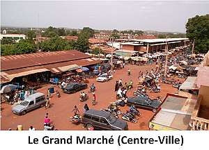
Attractions today include the large market, Mamelon hill, the remains of Tieba Traoré's tata, and the nearby Missirikoro Grotto. The festival Triangle du balafon takes place every June, celebrating the traditional Malian instrument.
Sikasso's sister city is Brive-la-Gaillarde, France.
Geography
Located 375 kilometres (233 mi) southeast of Bamako, 100 kilometres (62 mi) north of Côte d'Ivoire, and 45 kilometres (28 mi) west of Burkina Faso, Sikasso acts as a crossroads between the coastal countries (Togo, Bénin, Ghana, Côte d'Ivoire) and the landlocked Mali and Burkina Faso. Sikasso's ethnic groups include the Senufo Bamana,(mainly the Supyire), the Bobo (or Bobo Fing, lit. 'black Bobo'), and the Minianka (Mamara Senufo).
Sikasso has abundant agriculture. Sikasso's fruit and vegetable production guarantees the city's self-sufficiency, sparing it from reliance on international food aid.
Climate
Sikasso features a tropical wet and dry climate under the Köppen climate classification. The city receives just under 1,200 millimetres (47 in) of rain each year, most of which falls between May and October. August is the wettest month, with an average rainfall of 308.8 millimetres (12.16 in). The highest temperatures are reached at the end of the dry season in March and April when the average daily maximum temperatures are just above 37 °C (98.6 °F).[5]
| Climate data for Sikasso, Mali (1950–2000, extremes 1940–1994) | |||||||||||||
|---|---|---|---|---|---|---|---|---|---|---|---|---|---|
| Month | Jan | Feb | Mar | Apr | May | Jun | Jul | Aug | Sep | Oct | Nov | Dec | Year |
| Record high °C (°F) | 40.5 (104.9) |
41.2 (106.2) |
42.1 (107.8) |
42.0 (107.6) |
44.0 (111.2) |
39.2 (102.6) |
42.2 (108.0) |
36.7 (98.1) |
38.9 (102.0) |
38.9 (102.0) |
40.0 (104.0) |
39.2 (102.6) |
44.0 (111.2) |
| Average high °C (°F) | 33.5 (92.3) |
36.0 (96.8) |
37.4 (99.3) |
37.3 (99.1) |
35.6 (96.1) |
32.9 (91.2) |
30.7 (87.3) |
29.9 (85.8) |
31.0 (87.8) |
33.3 (91.9) |
34.4 (93.9) |
33.1 (91.6) |
33.8 (92.8) |
| Average low °C (°F) | 15.3 (59.5) |
18.3 (64.9) |
22.1 (71.8) |
24.6 (76.3) |
24.1 (75.4) |
22.4 (72.3) |
21.5 (70.7) |
21.4 (70.5) |
21.3 (70.3) |
21.5 (70.7) |
18.5 (65.3) |
15.2 (59.4) |
20.5 (68.9) |
| Record low °C (°F) | 8.2 (46.8) |
10.0 (50.0) |
13.0 (55.4) |
16.8 (62.2) |
17.1 (62.8) |
17.7 (63.9) |
17.2 (63.0) |
17.0 (62.6) |
18.0 (64.4) |
14.0 (57.2) |
10.0 (50.0) |
8.0 (46.4) |
8.0 (46.4) |
| Average rainfall mm (inches) | 1.4 (0.06) |
4.1 (0.16) |
12.8 (0.50) |
45.9 (1.81) |
109.1 (4.30) |
152.3 (6.00) |
243.7 (9.59) |
308.8 (12.16) |
210.0 (8.27) |
84.4 (3.32) |
11.7 (0.46) |
2.0 (0.08) |
1,186.2 (46.71) |
| Average rainy days (≥ 0.1 mm) | 0.2 | 0.6 | 2.3 | 5.4 | 9.9 | 12.7 | 17.0 | 20.0 | 14.5 | 9.0 | 1.4 | 0.2 | 93.2 |
| Average relative humidity (%) | 31 | 27 | 33 | 48 | 61 | 72 | 79 | 82 | 80 | 71 | 52 | 38 | 56 |
| Mean monthly sunshine hours | 263.1 | 242.3 | 237.6 | 217.5 | 242.0 | 220.8 | 203.2 | 176.6 | 190.7 | 243.0 | 257.6 | 261.6 | 2,756 |
| Source 1: World Meteorological Organization[5] | |||||||||||||
| Source 2: NOAA (sun 1961–1990),[6] Deutscher Wetterdienst (extremes and humidity)[7] | |||||||||||||
Places of worship
Among the places of worship, they are predominantly Muslim mosques. [8] There are also Christian churches and temples : Roman Catholic Diocese of Sikasso (Catholic Church), Église Chrétienne Évangélique du Mali (Alliance World Fellowship), Assemblies of God.
See also
References
- "Common and Fundamental Operational Datasets Registry: Mali", United Nations Office for the Coordination of Humanitarian Affairs https://web.archive.org/web/20120106202217/http://cod.humanitarianresponse.info/country-region/mali, archived from the original on 2012-01-06 Missing or empty
|title=(help). commune_mali.zip (Originally from the Direction Nationale des Collectivités Territoriales, République du Mali) - Maps, Weather, and Airports for Sikasso, Mali Archived 2008-02-21 at the Wayback Machine
- Resultats Provisoires RGPH 2009 (Région de Sikasso) (PDF) (in French), République de Mali: Institut National de la Statistique, archived from the original (PDF) on 2012-07-27.
- L-G. Binger, Du Niger au golfe de Guinée, Hachette, 1892, p. 88
- "World Weather Information Service – Sikasso". World Meteorological Organization. Retrieved 12 October 2015.
- "Sikasso Climate Normals 1961–1990". National Oceanic and Atmospheric Administration. Retrieved 12 October 2015.
- "Klimatafel von Sikasso / Mali" (PDF). Baseline climate means (1961-1990) from stations all over the world (in German). Deutscher Wetterdienst. Retrieved 26 January 2016.
- J. Gordon Melton, Martin Baumann, ‘‘Religions of the World: A Comprehensive Encyclopedia of Beliefs and Practices’’, ABC-CLIO, USA, 2010, p. 1793
External links
| Wikimedia Commons has media related to Sikasso. |
- Portions of this article were translated from French language Wikipedia's Sikasso.
- Plan de Sécurité Alimentaire Commune Urbaine de Sikasso 2007-2011 (PDF) (in French), Commissariat à la Sécurité Alimentaire, République du Mali, USAID-Mali, 2007.
- L'économie locale de Sikasso, Mali. Ecoloc - Gérer l'économie localement en Afrique - Evaluation et prospective, Volume 1, Number 2, Décembre 2002, pp. 1–18 (18).
