Si Thep District
Si Thep (Thai: ศรีเทพ, pronounced [sǐː tʰêːp]) is the southernmost district (amphoe) of Phetchabun Province, Thailand, in the valley of the Pa Sak River. Si Thep, now on a tentative list of UN World Heritage Sites, is Thailand's largest ancient city.[1]
Si Thep ศรีเทพ | |
|---|---|
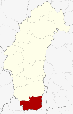 District location in Phetchabun Province | |
| Coordinates: 15°27′12″N 101°4′2″E | |
| Country | Thailand |
| Province | Phetchabun |
| Seat | Khok Sa-at |
| Area | |
| • Total | 810.0 km2 (312.7 sq mi) |
| Population (2000) | |
| • Total | 63,300 |
| • Density | 78.1/km2 (202/sq mi) |
| Time zone | UTC+7 (ICT) |
| Postal code | 67170 |
| Geocode | 6706 |
History
Higham reports of a 7th-century Dvaravati inscription from Sri Thep that states, "In the year...a king who is nephew of the great King, who is the son of Pruthiveenadravarman, and who is great as Bhavavarman, who has renowned moral principles, who is powerful and the terror of his enemies, erects this inscription on ascending the throne." A moat enclosed 4.7 square km, while the Khao Klang Nai structure dates from the 6th to 7th century. Prang Song Phi Nong and Prang Sri Thep were built in the 11th to 12th centuries.[2]:303,308–309
The district was created on 13 December 1970 as a minor district (king amphoe) with territory from Wichian Buri District. It was upgraded to Si Thep District on 8 August 1976.[3]
The ancient city of Si Thep was built in the Khmer era. Prince Damrong found the area of the old city in 1905 when he visited Monthon Phetchabun. It is now Si Thep Historical Park.
Geography
Si Thep is on a dry highland surrounded by waterways and floodplains bordered by mountains on both sides. To ensure sufficient water for city use, ancient Si Thep had an elaborate system of ponds, tank moats, and a hydraulic system to bring water from higher grounds to sustain the city.[1]
Neighboring districts are (from the north clockwise) Wichian Buri of Phetchabun Province, and Lam Sonthi, Chai Badan, and Khok Charoen of Lopburi Province.
Administration
The district is divided into seven sub-districts (tambons), which are further subdivided into 93 villages (mubans). The township (thesaban tambon) Sawang Watthana covers parts of tambon Sa Kruat. There are seven tambon administrative organizations (TAO).
|
References
- Ekachai, Sanitsuda (28 September 2019). "Opening minds with an ancient 'mandala'". Bangkok Post. Retrieved 28 September 2019.
- Higham, C., 2014, Early Mainland Southeast Asia, Bangkok: River Books Co., Ltd., ISBN 9786167339443
- amphoe.com