Shiura, Aomori
Shiura (市浦村, Shiura-mura) was a village located in Kitatsugaru District in western Aomori Prefecture, Japan.
Shiura 小泊村 | |
|---|---|
Former municipality | |
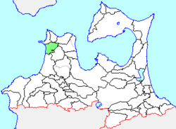 Location of Shiura in Aomori Prefecture | |
 Shiura Location in Japan | |
| Coordinates: 41°3′18″N 140°20′43.9″E | |
| Country | Japan |
| Region | Tōhoku |
| Prefecture | Aomori Prefecture |
| District | Kitatsugaru |
| Merged | March 28, 2005 (now part of Goshogawara) |
| Area | |
| • Total | 111.75 km2 (43.15 sq mi) |
| Population (March 1, 2005) | |
| • Total | 2,708 |
| • Density | 24.23/km2 (62.8/sq mi) |
| Symbols | |
| • Tree | Hiba |
| • Flower | Oenothera |
| • Bird | Black kite |
| Time zone | UTC+9 (JST) |
Shiura was located in northwest corner of Tsugaru Peninsula facing the Sea of Japan. The area was part of Hirosaki Domain during the Edo period. After the Meiji Restoration, Shiura Village was created on March 31, 1955 through the merger of Aiuchi, Jusan and Wakimoto villages.
On March 28, 2005, Shiura, along with the neighboring town of Kanagi (also from Kitatsugaru District), was merged into the expanded city of Goshogawara, and thus no longer exists as an independent municipality.
At the time of its merger, Shiura had an estimated population of 2,708 and a population density of 24.23 persons per km2. The total area was 111.75 km2.
The village economy was dominated by commercial fishing and agriculture. The village was on Route 339 (Japan) highway.
| Authority control |
|
|---|