Shirakawa, Fukushima
Shirakawa (白河市, Shirakawa-shi) is a city located in Fukushima Prefecture, Japan. As of 1 April 2020, the city had an estimated population of 59,393 in 23,546 households [1] and a population density of 190 persons per km2. The total area of the city was 305.3 square kilometres (117.9 sq mi).
Shirakawa 白河市 | |
|---|---|
 Shirakawa City Hall | |
Flag Seal | |
Location of Shirakawa in Fukushima Prefecture | |
 Shirakawa | |
| Coordinates: 37°07′34.7″N 140°12′39.3″E | |
| Country | Japan |
| Region | Tōhoku |
| Prefecture | Fukushima |
| Area | |
| • Total | 305.32 km2 (117.88 sq mi) |
| Population (April 2020) | |
| • Total | 59,393 |
| • Density | 190/km2 (500/sq mi) |
| Time zone | UTC+9 (Japan Standard Time) |
| City symbols | |
| • Tree | Pinus densiflora |
| • Flower | Ume |
| • Bird | Emberiza cioides |
| Phone number | 0248-22-1111 |
| Address | 7-1 Hachimankōji, Shirakawa, Fukushima 961-0941 |
| Website | Official website |
Geography
Shirakawa is located in south-central Fukushima prefecture facing the Nasu plateau, and extending to the lowland Shirakawa Basin.
- Rivers: Abukuma River
Climate
Shirakawa has a humid continental climate (Köppen Cfa) characterized by mild summers and cold winters. The average annual temperature in Shirakawa is 11.4 °C. The average annual rainfall is 1377 mm with September as the wettest month. The temperatures are highest on average in August, at around 25.0 °C, and lowest in January, at around 0.3 °C.[2]
| Climate data for Shirakawa, Fukushima | |||||||||||||
|---|---|---|---|---|---|---|---|---|---|---|---|---|---|
| Month | Jan | Feb | Mar | Apr | May | Jun | Jul | Aug | Sep | Oct | Nov | Dec | Year |
| Average high °C (°F) | 4.4 (39.9) |
4.6 (40.3) |
8.2 (46.8) |
15.4 (59.7) |
20.5 (68.9) |
22.9 (73.2) |
26.3 (79.3) |
28.2 (82.8) |
23.3 (73.9) |
17.8 (64.0) |
12.7 (54.9) |
7.4 (45.3) |
16.0 (60.8) |
| Daily mean °C (°F) | −0.2 (31.6) |
0.2 (32.4) |
3.3 (37.9) |
9.7 (49.5) |
14.9 (58.8) |
18.3 (64.9) |
21.9 (71.4) |
23.3 (73.9) |
18.9 (66.0) |
12.7 (54.9) |
7.4 (45.3) |
2.4 (36.3) |
11.1 (51.9) |
| Average low °C (°F) | −4.4 (24.1) |
−3.9 (25.0) |
−1.4 (29.5) |
4.2 (39.6) |
9.4 (48.9) |
14.4 (57.9) |
18.5 (65.3) |
19.8 (67.6) |
15.3 (59.5) |
8.2 (46.8) |
2.5 (36.5) |
−2.1 (28.2) |
6.7 (44.1) |
| Average precipitation mm (inches) | 29.0 (1.14) |
43.3 (1.70) |
67.7 (2.67) |
99.2 (3.91) |
112.6 (4.43) |
177.7 (7.00) |
162.9 (6.41) |
200.9 (7.91) |
191.1 (7.52) |
116.3 (4.58) |
63.5 (2.50) |
33.4 (1.31) |
1,297.6 (51.08) |
| Average snowfall cm (inches) | 24 (9.4) |
30 (12) |
18 (7.1) |
3 (1.2) |
0 (0) |
0 (0) |
0 (0) |
0 (0) |
0 (0) |
0 (0) |
2 (0.8) |
15 (5.9) |
92 (36.4) |
| Average relative humidity (%) | 68 | 67 | 65 | 66 | 70 | 80 | 84 | 82 | 82 | 77 | 73 | 70 | 74 |
| Mean monthly sunshine hours | 164.6 | 154.2 | 187.4 | 182.9 | 196.8 | 131.7 | 129.2 | 156.2 | 111.3 | 144.0 | 144.8 | 156.4 | 1,859.5 |
| Source: NOAA (1961-1990) [3] | |||||||||||||
Demographics
 | ||||||||||||||||||||||||||||
| Comparison of Population Distribution between Shirakawa and Japanese National Average | Population Distribution by Age and Sex in Shirakawa | |||||||||||||||||||||||||||
■Shirakawa ■Japan (average) |
■Male ■Female | |||||||||||||||||||||||||||
| ||||||||||||||||||||||||||||
| 2015 Census, Ministry of Internal Affairs and Communications - Statistics Department | ||||||||||||||||||||||||||||
History
The area of present-day Shirakawa was part of ancient Mutsu Province and was the location of a barrier gate on the Ōshū Kaidō connecting the capital at Kyoto with the northern provinces. In the Heian period, the Buddhist monk and waka poet Nōin composed the following poem about the region:
都をば霞とともに立ちしかど秋風ぞ吹く白河の関
Miyako wo ba kasumi to tomo ni tachishikado akikaze zo fuku Shirakawa no seki.
(English: I left the capital with the spring haze, but at the barrier of Shirakawa the autumn wind blows.)
In the Edo period the area prospered as a castle town Shirakawa Domain, and was the site of a major battle in the Boshin War during the Meiji restoration. In the Meiji period, it was organized as part of Nakadōri region of Iwaki Province.
The town of Shirakawa was formed on April 1, 1889 with the creation of the modern municipalities system. On April 1, 1949, Shirakawa was elevated to city status after merging with the neighboring village of Ōnuma. Subsequent mergers occurred in 1954 and 1955 with the inclusion of the villages of Shirasaka, Odagawa, Goka and a portion of Omotegō into the territory of Shirakawa. On November 7, 2005, the villages of Taishin, Higashi, and the remainder of Omotegō (all from Nishishirakawa District) were merged into Shirakawa, increasing its population from 48,297 to approximately 66,000 and territory from 117.67 km2 (45.43 sq mi) to 305.30 km2 (117.88 sq mi).
Government
Shirakawa has a mayor-council form of government with a directly elected mayor and a unicameral city legislature of 26 members. Shirakawa, together with Nishishirakawa District contributes three members to the Fukushima Prefectural Assembly. In terms of national politics, the city is part of Fukushima 3rd district of the lower house of the Diet of Japan.
Economy
Shirakawa has a mixed economy, and is a major commercial center for the surrounding region. Principal industries include electrical appliances, construction materials and clothing.[4]
Education
Shirakawa has fifteen public elementary schools and eight junior high schools operated by the city government and four public high schools operated by the Fukushima Prefectural Board of Education.
Post offices
Shirakawa has nineteen post offices within the boundaries of the city.[5]
Transportation
Railway
Local attractions
- Site of Shirakawa Barrier - National Historic Site
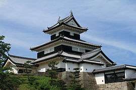
- Komine Castle – One of the 100 Castles of Japan
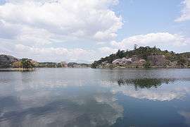
- Nanko Park – National Historic Site and National Scenic Site
- Shirakawa Funada – Honnuma Kofun – kofun period burial tumulus, National Historic Site
- Festivals held in Shirakawa include "Daruma Ichi", celebrating the traditional Daruma doll, wherein the city streets are packed with stalls selling Daruma, a variety of festival foods and charms, and "Chōchin Matsuri" (Lantern Festival), which is held each summer, with a special three-day celebration held once every three years.
International relations


Noted people from Shirakawa
- Gishu Nakayama, writer
- Atsushi Fujita, Olympic marathon runner
- Hideo Madarame, Olympic cyclist
- Toshiaki Fushimi, Olympic cyclist
References
- Shirakawa city official statistics(in Japanese)
- Shirakawa climate data
- "Shirakawa Climate Normals 1961-1990". National Oceanic and Atmospheric Administration. Retrieved December 30, 2012.
- Campbell, Allen; Nobel, David S (1993). Japan: An Illustrated Encyclopedia. Kodansha. p. 1396. ISBN 406205938X.
- List of Post Offices in Shirakawa Archived 2013-02-05 at Archive.today (in Japanese)
External links
![]()
| Wikivoyage has a travel guide for Shirakawa. |
- Official website (in Japanese)
Fukushima (capital) | ||
| Core cities |
| |
| Cities | ||
| Districts | ||
| Authority control |
|
|---|