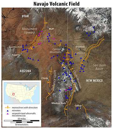
Shiprock
Shiprock (Navajo: Tsé Bitʼaʼí, "rock with wings" or "winged rock"[4]) is a monadnock rising nearly 1,583 feet (482.5 m) above the high-desert plain of the Navajo Nation in San Juan County, New Mexico, United States. Its peak elevation is 7,177 feet (2,187.5 m) above sea level. It lies about 10.75 miles (17.30 km) southwest of the town of Shiprock, which is named for the peak.
| Shiprock | |
|---|---|
| Tsé Bitʼaʼí | |
 Shiprock | |
| Highest point | |
| Elevation | 7,177 ft (2,188 m) |
| Prominence | 1,583 ft (482 m) |
| Coordinates | 36°41′15″N 108°50′11″W [1] |
| Geography | |
 Shiprock New Mexico | |
| Location | San Juan County, New Mexico, US |
| Topo map | USGS Ship Rock Quadrangle |
| Geology | |
| Age of rock | 27 million years |
| Mountain type | Volcanic breccia and minette |
| Climbing | |
| First ascent | (First documented) 1939 by David Brower, Raffi Bedayn, Bestor Robinson and John Dyer[2][3] |
| Designated | 1975 |
Governed by the Navajo Nation, the formation is in the Four Corners region and plays a significant role in Navajo religion, myth, and tradition. It is located in the center of the area occupied by the Ancient Pueblo People, a prehistoric Native American culture of the Southwest United States often referred to as the Anasazi. Shiprock is a point of interest for rock climbers and photographers and has been featured in several film productions and novels. It is the most prominent landmark in northwestern New Mexico. In 1975, Shiprock was designated as a National Natural Landmark by the National Park Service.[5]
Name
The Navajo name for the peak, Tsé Bitʼaʼí, "rock with wings" or "winged rock", refers to the legend of the great bird that brought the Navajo from the north to their present lands.[6][7] The name "Shiprock" or Shiprock Peak or Ship Rock derives from the peak's resemblance to an enormous 19th-century clipper ship. Americans first called the peak "The Needle", a name given to the topmost pinnacle by Captain J. F. McComb in 1860.[7] United States Geological Survey maps indicate that the name "Ship Rock" dates from the 1870s.[6][7]
Geology
Shiprock is composed of fractured volcanic breccia and black dikes of igneous rock called minette, or lamprophyre. It is the erosional remnant of the throat of a volcano, and the volcanic breccia formed in a diatreme. The rock probably was originally formed 2,500–3,000 feet (750–1,000 meters) below the Earth's surface, but it was exposed after millions of years of erosion.[8] Wall-like sheets of minette, known as dikes, radiate away from the central formation. Radiometric age determinations of the minette establish that these volcanic rocks solidified about 27 million years ago. Shiprock is in the northeastern part of the Navajo Volcanic Field—a field that includes intrusions and flows of minette and other unusual igneous rocks that formed about 30 million years ago. Agathla (El Capitan) in Monument Valley is another prominent volcanic neck in this volcanic field.[9][10]
Religious and cultural significance
Shiprock and the surrounding land have religious and historical significance to the Navajo people. It is mentioned in many of their myths and legends. Foremost is the peak's role as the agent that brought the Navajo to the southwest. According to one legend, after being transported from another place, the Navajos lived on the monolith, "coming down only to plant their fields and get water."[7] One day, the peak was struck by lightning, obliterating the trail and leaving only a sheer cliff, and stranding the women and children on top to starve. The presence of people on the peak is forbidden "for fear they might stir up the chį́įdii (ghosts), or rob their corpses."[7]
Navajo legend puts the peak in a larger geographic context. Shiprock is said to be either a medicine pouch or a bow carried by the "Goods of Value Mountain", a large mythic male figure comprising several mountain features throughout the region. The Chuska Mountains comprise the body, Chuska Peak is the head, the Carrizo Mountains are the legs, and Beautiful Mountain is the feet.[7]
Navajo legend has it that Bird Monsters (Tsé Ninájálééh) nested on the peak and fed on human flesh. After Monster Slayer, elder of the Warrior Twins, destroyed Déélééd at Red Mesa, he killed two adult Bird Monsters at Shiprock and changed two young ones into an eagle and an owl.[7][11] The peak is mentioned in stories from the Enemy Side Ceremony and the Navajo Mountain Chant, and is associated with the Bead Chant and the Naayee'ee Ceremony.[7] There are a number of other legends regarding what the Shiprock pinnacle might be. Some Navajo traditionalists argue that it is a geological anomaly that may have originated as a work of the 'star people'.
Restrictions on the formation
An injury to a climber in April 1966 (American Alpine Journal 1966 accident report[12]) caused the Navajo Nation to ban rock climbing not only on Shiprock but all over the Navajo Nation on monoliths, spires and within tribal parks under the jurisdiction of Navajo Parks & Recreation. The Navajo Nation announced that the ban was "absolute, final and unconditional". Due to "the Navajo's traditional fear of death and its aftermath, such accidents and especially fatalities often render the area where they occur as taboo, and the location is sometimes henceforth regarded as contaminated by evil spirits and is considered a place to be avoided." The pinnacle is located on private property of Navajo grazing lease holders and is currently monitored and overseen by Shiprock tribal community advocates. Two Navajo chapter tribal government organizations claim jurisdiction over the formation. The Navajo tribal parks and recreation department does not have jurisdiction over the formation because it is not presently a tribal park. The formation is a highly sacred religious site to the Navajo people.
Due to recent deaths, littering, and vandalism, the pinnacle has been under strict evaluation and observation by local Shiprock Pinnacle Tribal Advocates and by two Navajo Chapter organizations since early 2016, who oversee the area and encourage the public to not drive around the formation as if it had open access. Hiking, filming, and driving are all prohibited to the public due to its sacred nature and its sacred space. According to the Navajo traditionalists, an ecosystem of living and non-living matter needs to be protected and unharmed. In the Navajo traditional way, people are to respect the ecosystem and not disrupt its processes. It is recommended that the public respect the Navajo people who visit daily for religious activities and other miscellaneous purposes as it is Navajo trust land. A core/protection and buffer zones will be established soon. Local Shiprock Pinnacle Tribal Advocates and the two Navajo Chapter organizations also encourage visitors to use common sense etiquette and remember that the Navajo Nation is a sovereign, self-governed nation with rules and laws that must be followed.
All areas near the formation are closed to non-Natives for the traditional religious purposes and for the safety of the formation and lava dike. It is recommended that the public stay at least three miles (4.8 km) away from the formation and 20 feet (6.1 m) from the lava dikes or wall when visiting. Navajo religious rights (the Fundamental Laws of the Dine' (Dine' Natural Law) from the Navajo Nation Title 1 Laws), Navajo grazing rights, boundaries, and private properties lines apply around and in the formation. The formation is a Navajo religious site. The restrictions were put in place in July 2016 by the delegated tribal authority (i.e., Navajo families and grazing holders who live around the formation, Shiprock Pinnacle Tribal Advocates, and members of the Navajo Chapters & Tribal Council). Visitors without any proper tribal authorization will be considered to be trespassing on Federal Indian Reservation land and are subject to legal sanctions. The tribal police at the formation monitor its use and visits.
Climate
| Climate data for Shiprock, NM | |||||||||||||
|---|---|---|---|---|---|---|---|---|---|---|---|---|---|
| Month | Jan | Feb | Mar | Apr | May | Jun | Jul | Aug | Sep | Oct | Nov | Dec | Year |
| Record high °F (°C) | 66 (19) |
78 (26) |
83 (28) |
91 (33) |
99 (37) |
107 (42) |
109 (43) |
106 (41) |
99 (37) |
92 (33) |
78 (26) |
72 (22) |
109 (43) |
| Average high °F (°C) | 43.0 (6.1) |
50.6 (10.3) |
59.9 (15.5) |
70.0 (21.1) |
79.8 (26.6) |
90.1 (32.3) |
94.6 (34.8) |
91.9 (33.3) |
85.1 (29.5) |
72.4 (22.4) |
56.2 (13.4) |
44.1 (6.7) |
69.8 (21.0) |
| Average low °F (°C) | 15.7 (−9.1) |
21.5 (−5.8) |
27.5 (−2.5) |
34.9 (1.6) |
43.8 (6.6) |
51.2 (10.7) |
58.8 (14.9) |
57.3 (14.1) |
48.0 (8.9) |
36.0 (2.2) |
25.1 (−3.8) |
16.9 (−8.4) |
36.4 (2.5) |
| Record low °F (°C) | −18 (−28) |
−14 (−26) |
2 (−17) |
9 (−13) |
15 (−9) |
28 (−2) |
30 (−1) |
33 (1) |
21 (−6) |
10 (−12) |
0 (−18) |
−26 (−32) |
−26 (−32) |
| Average precipitation inches (mm) | 0.46 (12) |
0.46 (12) |
0.54 (14) |
0.41 (10) |
0.51 (13) |
0.29 (7.4) |
0.66 (17) |
1.00 (25) |
0.80 (20) |
0.78 (20) |
0.52 (13) |
0.57 (14) |
7 (177.4) |
| Average snowfall inches (cm) | 1.6 (4.1) |
0.7 (1.8) |
0.6 (1.5) |
0 (0) |
0 (0) |
0 (0) |
0 (0) |
0 (0) |
0 (0) |
0 (0) |
0.2 (0.51) |
1.0 (2.5) |
4.1 (10.41) |
| Source: http://www.wrcc.dri.edu/cgi-bin/cliMAIN.pl?nm8284 | |||||||||||||
Images
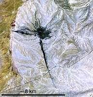 Ship Rock and associated dikes, in a cropped, marked, and lower-resolution image from original by NASA Visible Earth. This image was acquired by an ASTER sensor and colors are not photo-like.
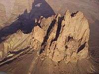 Aerial view of Shiprock
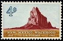 Shiprock on a 1962 U.S. commemorative stamp
See also
- Rock formations in the United States
- Volcanic plug
- Diné Bahaneʼ
References
- "Ship Rock". Geographic Names Information System. United States Geological Survey. Retrieved November 30, 2008.
- Audrey Salkeld, editor, World Mountaineering, Bulfinch, 1998.
- Herbert E. Ungnade, Guide to the New Mexico Mountains, Sage Books, 1965, pp. 170–172.
- Wall, Leon; William Morgan (1994) [1958]. Navajo-English Dictionary. New York: Hippocrene. ISBN 0-7818-0247-4.
- "National Natural Landmarks - National Natural Landmarks (U.S. National Park Service)". www.nps.gov. Retrieved March 25, 2019.
Year designated: 1975
- Butterfield, Mike, and Greene, Peter, Mike Butterfield's Guide to the Mountains of New Mexico, New Mexico Magazine Press, 2006, ISBN 978-0-937206-88-1
- Laurance D. Linford, Navajo Places: History, Legend, Landscape, University of Utah Press, Salt Lake City, 2000, ISBN 0-87480-623-2, p. 264–265.
- Scheffel, Richard L.; Wernet, Susan J., eds. (1980). Natural Wonders of the World. United States of America: Reader's Digest Association, Inc. pp. 343. ISBN 0-89577-087-3.
- Steven C. Semken, The Navajo Volcanic Field, in Volcanology in New Mexico, New Mexico Museum of Natural History and Science Bulletin 18, p. 79–83, 2001. ISSN 1524-4156
- Paul T. Delaney, Ship Rock, New Mexico: The vent of a violent volcanic eruption, Geological Society of America Centennial Field Guide—Rocky Mountain Section, pp. 411–415, 1987.
- Shiprock on Dark Isle
- "New Mexico, Shiprock - AAC Publications - Search The American Alpine Journal and Accidents". publications.americanalpineclub.org. Retrieved April 19, 2019.
External links
| Wikimedia Commons has media related to Shiprock. |