Shamrock Township, Callaway County, Missouri
Shamrock Township is one of eighteen townships in Callaway County, Missouri, USA. As of the 2010 census, its population was 413.[3]
Shamrock Township | |
|---|---|
 | |
| Coordinates: 39°00′11″N 091°41′50″W | |
| Country | United States |
| State | Missouri |
| County | Callaway |
| Area | |
| • Total | 42.97 sq mi (111.29 km2) |
| • Land | 42.9 sq mi (111.11 km2) |
| • Water | 0.07 sq mi (0.18 km2) 0.16% |
| Elevation | 755 ft (230 m) |
| Population (2010) | |
| • Total | 413 |
| • Density | 9.6/sq mi (3.7/km2) |
| FIPS code | 29-66962[2] |
| GNIS feature ID | 0766385 |
History
Shamrock Township was created between 1876 and 1897, per official county maps from these two years, from the northeast 1/4 (approximately) of what before then was a much larger Nine Mile Prairie Township. It's named for the shamrock, a national symbol of Ireland.[4]
Geography
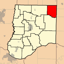
Shamrock Township covers an area of 42.97 square miles (111.3 km2) and contains no incorporated settlements, although the unincorporated village of Shamrock.
The streams of Appling Branch, Bachelor Creek, Brushy Branch, Harrison Creek, Heat String Creek and Morris Branch run through this township, which also contains three cemeteries named Augusta, Chatman, and Sawyers.
The township is bordered on the west by Jackson Township (Auxvasse), on the south by Nine Mile Prairie Township (Williamsburg), on the north by Audrain County, and on the east by Montgomery County.
References
- "US Board on Geographic Names". United States Geological Survey. 2007-10-25. Retrieved 2008-01-31.
- "U.S. Census website". United States Census Bureau. Retrieved 2008-01-31.
- "Race, Hispanic or Latino, Age, and Housing Occupancy: 2010 Census Redistricting Data (Public Law 94-171) Summary File (QT-PL), Shamrock township, Callaway County, Missouri". United States Census Bureau. Retrieved October 31, 2011.
- Eaton, David Wolfe (1916). How Missouri Counties, Towns and Streams Were Named. The State Historical Society of Missouri. pp. 268.
External links
Municipalities and communities of Callaway County, Missouri, United States | ||
|---|---|---|
| Cities | 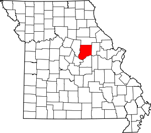 Map of Missouri highlighting Callaway County | |
| Village | ||
| Townships | ||
| Unincorporated communities | ||
| Ghost towns | ||
| Footnotes | ‡This populated place also has portions in an adjacent county or counties | |