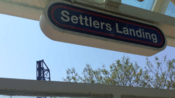
Settlers Landing station
Settlers Landing is a station on the RTA Waterfront Line in Cleveland, Ohio, USA. The station is located just south of the intersection of West Superior Avenue and Old River Road.
Settlers Landing | |||||||||||
|---|---|---|---|---|---|---|---|---|---|---|---|
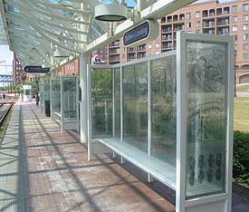
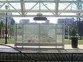
 The Settlers Landing station in July 2018. | |||||||||||
| Location | 1199 West Superior Avenue, Cleveland, Ohio | ||||||||||
| Coordinates | 41°29′47″N 81°42′1″W | ||||||||||
| Owned by | Greater Cleveland RTA | ||||||||||
| Platforms | 2 side platforms | ||||||||||
| Tracks | 2 | ||||||||||
| Construction | |||||||||||
| Structure type | At grade | ||||||||||
| Disabled access | |||||||||||
| Other information | |||||||||||
| Website | Settlers Landing Rapid Station | ||||||||||
| History | |||||||||||
| Opened | July 10, 1996[1] | ||||||||||
| Services | |||||||||||
| |||||||||||
It is the first station beyond Tower City station on the Waterfront line, which extended the Green and Blue Lines into The Flats along the east bank of the Cuyahoga River and along the Lake Erie waterfront. The station is adjacent to the Settlers Landing historical site which marks the location where Moses Cleaveland and his surveying team disembarked from the Cuyahoga River to survey the city in 1796.
History
The station opened on July 10, 1996,[1] when light rail service was extended 2.2 miles from Tower City through The Flats and along the lakefront. This extension was designated the Waterfront Line, although it is actually an extension of the Blue and Green Lines, as trains leaving this station toward Tower City continue along the Blue or Green Line routes to Shaker Heights.
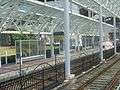
Station layout
| P Platform level |
Side platform | |
| Outbound | ← Waterfront Line toward South Harbor (Flats East Bank) | |
| Inbound | Waterfront Line toward Tower City (Terminus) → | |
| Side platform | ||
| Street level | Exit/entrance | |
Notable places nearby
- The Flats
- The Warehouse District
- Detroit-Superior Bridge
- Jacobs Pavilion
Artwork
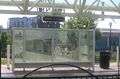
The station includes eight etched glass panels created by local artist Martin Boyle. The panels join to make up windscreens to shield waiting riders at the outdoor station. Each of the panels, which measure 63 inches by 24 or 20 inches, have fine, detailed etchings of ships, canoes, early settlers in covered wagons and local waterways illustrating different local transportation eras. Each image is hand-drawn in a classical etching style and using a crosshatch technique. One illustration is a map of Cleaveland's route to the Cuyahoga.[2][3]
Gallery


References
- "History of public transit in Greater Cleveland". Cleveland, Ohio: Greater Cleveland Regional Transit Authority. 2012. Retrieved April 17, 2015.
- Simmons, Sheila (June 7, 1996). "Take the A(rt) train; Waterfront Line patrons may be transported aesthetically, as well, when they see the work artisans have done". The Plain Dealer. pp. 1J. Retrieved March 13, 2007.
- Simmons, Sheila (June 7, 1996). "Windscreens trace transportation history". The Plain Dealer. pp. 4J. Retrieved May 7, 2007.
External links
| Wikimedia Commons has media related to Settlers Landing station. |