Sendamangalam
Sendamangalam is a Taluk in the Indian state of Tamil Nadu is situated in Namakkal District.
Senthamangalam | |
|---|---|
 | |
| Nickname(s): | |
 Senthamangalam Location in Namakkal, Tamil Nadu, India | |
| Coordinates: 11.3000°N 78.2333°E | |
| Country | |
| State | Tamil Nadu |
| Region | Kongu Nadu |
| District | Namakkal |
| Government | |
| • Type | Municipal Corporation |
| • Body | Senthamangalam City Corporation |
| Elevation | 240 m (790 ft) |
| Population (2001) | |
| • Total | 18,085 |
| Languages | |
| • Official | Tamil |
| Time zone | UTC+5:30 (IST) |
| PIN | 637409 |
| Telephone code | 91-4286 |
| Vehicle registration | TN-88, Namakkal South |
Geography
Sendamangalam is located at 11.3000°N 78.2333°E.[1] It has an average elevation of 240 metres (715 feet). It is close to Kolli Hills (கொல்லி மலை) - which is part of the Eastern Ghats. The closest river is Kaveri. The city is approximately 350 km southwest of Chennai, 255 km south of Bangalore, 50 km south of Salem and 93 km northwest of Tiruchirapalli (Trichy) and around 200 km North of Madurai.
History
Between CE. 1216 and 1279 CE, Sendamangalam was the capital of the Kadava kings Kopperunchinga I & Kopperunchinga II, who converted it into a military stronghold and fought successfully against Kulothunga Chola III and Rajaraja Chola III, against successive Hoysala kings, and against Jatavarman Sundara Pandyan. The Kadavas remained friendly with the Magadai/Aragalur chief 'Magadan Rajarajadevan pon parappinan Magadaipprumal' and the Tirukoilur chief Malayaman. Their kingdom was eradicated by the campaigns of Maaravarman Kulasekara Pandyan I. After the fall of Hoysalas, Vijayanagar Empire, Madurai Nayak ruled this part by Poligar Ramachandra Nayakar. This place was famous for nainamalai temple.
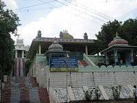
Another famous temple in this region is the Dattagiri Murugan temple which is also the Samadhi temple of Svyamprakasha Swamigal, Guru of Santhananda Swamigal of Pudukottai.
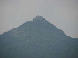
Nainamalai Varadaraja Perumal Koil is yet another famous temple near Sendamangalam.
Transport
Sendamangalam is located 12 km northeast from Namakkal on State Highway SH-95 (connecting Mohanur-Namakkal-Muthugapatti-Akkiampatty-Sendamangalam-Gandhipuram-Kalappanaickenpatty, Rasipuram, 54 km long). The nearest cities from Sendamangalam are Namakkal (12 km), Karur (45 km), Salem (50 km), Erode (62 km), and Tiruchirapalli (93 km). Chennai, the capital of the state, is 380 km from Namakkal. The nearest airport is in Salem(55 km). The nearest major railway station is at Namakkal (10 km) and Salem (55 km).
Climate
The temperature ranges from 20 to 44°C throughout the year.
Demographics
As of 2001 India census,[2] Sendamangalam had a population of 18,085. Males constitute 50% of the population and females 50%. Sendamangalam has an average literacy rate of 64%, higher than the national average of 59.5%: male literacy is 73%, and female literacy is 56%. In Sendamangalam, 9% of the population is under 6 years of age.
Taluk
Sendamangalam Taluk in Namakkal (Lok Sabha constituency) started functioning as Taluk from 2 June 2015.[3] The taluk office started functioning at a private building on Sendamangalam – Budhansandai Road near Primary Agriculture Cooperative Credit Society.
Currently, two Tahsildars, five Deputy Tahsildars and 26 officials were appointed for the new Taluk.
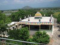
Temples
- Thatagiri Murugan temple
- Shivan temple
- Vishnu temple
Politics
Sendamangalam assembly constituency (ST) Sendamangalam Taluk is part of Namakkal (Lok Sabha constituency).[4]
See also
References
- Falling Rain Genomics, Inc - Sendamangalam
- "Census of India 2001: Data from the 2001 Census, including cities, villages and towns (Provisional)". Census Commission of India. Archived from the original on 16 June 2004. Retrieved 1 November 2008.
- "New Taluks begin to function". The Hindu. 3 June 2015. Retrieved 13 December 2018.
- "List of Parliamentary and Assembly Constituencies" (PDF). Tamil Nadu. Election Commission of India. Archived from the original (PDF) on 4 May 2006. Retrieved 9 October 2008.
External links
| Wikimedia Commons has media related to Sendamangalam. |