Selworthy
Selworthy is a small village and civil parish 5 kilometres (3 mi) from Minehead in Somerset, England. It is located in the National Trust's Holnicote Estate on the northern fringes of Exmoor. The parish includes the hamlets of Bossington, Tivington, Lynch, Brandish Street and Allerford.
| Selworthy | |
|---|---|
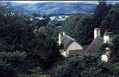 Looking over the village in Selworthy Combe | |
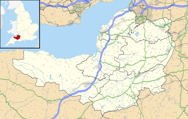 Selworthy Location within Somerset | |
| Population | 477 (2011)[1] |
| OS grid reference | SS917468 |
| District | |
| Shire county | |
| Region | |
| Country | England |
| Sovereign state | United Kingdom |
| Post town | MINEHEAD |
| Postcode district | TA24 |
| Dialling code | 01643 |
| Police | Avon and Somerset |
| Fire | Devon and Somerset |
| Ambulance | South Western |
| UK Parliament | |
At 308 metres (1,010 ft) Selworthy Beacon, rising above the village, is one of the highest points on Exmoor. Its height defines as one of the 'marilyns" in England. Near the summit are a series of cairns, thought to be the remains of round barrows,[2] and the British Iron Age Bury Castle.[3]
Bossington is separated from Porlock Bay by a shingle beach, through which flows the River Horner, forming part of the Porlock Ridge and Saltmarsh Site of Special Scientific Interest. In the 1990s rising sea levels created salt marshes, and lagoons developed in the area behind the boulder bank.[4] The village is on the South West Coast Path.
History
The name of the village means "enclosure or settlement near sallows or willows". In the Domesday Book it was recorded as Selewrda.[5] It was held by Queen Edith of Wessex in 1066 and, with Luccombe, was awarded to Ralph de Limesy by William the Conqueror. In 1301 Edward I awarded it to Henry de Pynkeny.[6] It passed down through the family until acquired by marriage by Sir Thomas Dyke Acland in 1802.[7]
Selworthy was part of the hundred of Carhampton.[8]
Selworthy was rebuilt as a model village, to provide housing for the aged and infirm of the Holnicote estate, in 1828 by Sir Thomas Acland,[9] in a similar style to Blaise Hamlet, Bristol, which had been built a few years earlier.[3] One of the cottages, known as Periwinkle Cottage, is now an award-winning tea room.[10] Many of the other cottages, whose walls are painted with limewash that has been tinted creamy yellow with ochre, some of which are now rented out, are still thatched and are listed buildings.[11][12][13] The village and the surrounding Holnicote estate was given to the National Trust in 1944 by Sir Richard Acland, having been passed down through the Acland family for nearly 200 years.[7]
Few of the buildings preceding 1828 survive, but those that do include the church, the tithe barn and Tithe Barn Cottage.[14]
Governance
Selworthy shares a grouped parish council with the civil parish of Minehead Without.[15] The parish council has responsibility for local issues, including setting an annual precept (local rate) to cover the council’s operating costs and producing annual accounts for public scrutiny. The parish council evaluates local planning applications and works with the local police, district council officers, and neighbourhood watch groups on matters of crime, security, and traffic. The parish council's role also includes initiating projects for the maintenance and repair of parish facilities, as well as consulting with the district council on the maintenance, repair, and improvement of highways, drainage, footpaths, public transport, and street cleaning. Conservation matters (including trees and listed buildings) and environmental issues are also the responsibility of the council.
The village falls within the non-metropolitan district of Somerset West and Taunton, which was established on 1 April 2019. It was previously in the district of West Somerset, which was formed on 1 April 1974 under the Local Government Act 1972, and part of Williton Rural District before that.[16] The district council is responsible for local planning and building control, local roads, council housing, environmental health, markets and fairs, refuse collection and recycling, cemeteries and crematoria, leisure services, parks, and tourism.
Somerset County Council is responsible for running the largest and most expensive local services such as education, social services, libraries, main roads, public transport, policing and fire services, trading standards, waste disposal and strategic planning.
As Selworthy falls within the Exmoor National Park some functions normally administered by district or county councils have, since 1997, fallen under the Exmoor National Park Authority, which is known as a ‘single purpose’ authority, which aims to "conserve and enhance the natural beauty, wildlife and cultural heritage of the National Parks" and "promote opportunities for the understanding and enjoyment of the special qualities of the Parks by the public",[17] including responsibility for the conservation of the historic environment.[18]
It is also part of the Bridgwater and West Somerset county constituency represented in the House of Commons of the Parliament of the United Kingdom. It elects one Member of Parliament (MP) by the first past the post system of election.
Church
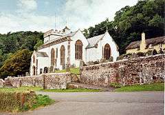
On the hill above the village is the whitewashed 15th-century Church of All Saints, with a 14th-century tower. The pulpit includes a 17th-century hourglass and the iron-bound parish chest dates from the same time.[19] Within the church is a copy of the Chained Book of 1609 by Bishop John Jewel, entitled Defense of the Apologie of the Church of England.[20]
It has been designated by English Heritage as a Grade I listed building.[21]
In the churchyard is a medieval cross with three octagonal steps, a square socket, and an octagonal shaft. The head is missing.[2][22] The churchyard provides views across the valley to Dunkery Beacon.[3]
The liturgical scholar and church historian Francis Carolus Eeles OBE is buried in the churchyard.[23]
The thatched Chapel of St Leonard, Tivington was built in the mid 14th century as a chapel of ease. It is a Grade II* listed building.[24]
The Lynch Chapel Of Ease at West Lynch dates from around 1530.[25]
Demography
The population of the parish of Selworthy is 477;[1] this has grown by 100 since 1801 when the population was 418.[26] It has a predominantly ageing population with 80% being over 45 years old.[27]
Gallery
 Tea room
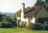 Thatched cottage
References
- "Statistics for Wards, LSOAs and Parishes — SUMMARY Profiles" (Excel). Somerset Intelligence. Retrieved 4 January 2014.
- Adkins, Lesley; Adkins, Roy (1992). A Field Guide to Somerset Archaeology. Wimborne, Dorset: Dovecote Press. p. 101. ISBN 0-946159-94-7.
- Dunning, Robert (1980). Somerset and Avon. Edinburgh: John Bartholomew & Son. p. 125. ISBN 0-7028-8380-8.
- "Shifting shores in the South West" (PDF). National Trust. Archived from the original (PDF) on 6 December 2008. Retrieved 13 October 2008.
- "Selworthy Parish". Exmoor National Park. Archived from the original on 16 July 2011. Retrieved 26 January 2008.
- Savage, James (1830). History of the Hundred of Carhampton: In the County of Somerset. Longman, Rees, Orme, Brown, & Green. pp. 182–196.
- Morgan Evans, David; Salway, Peter; Thackray, David (1996). The Remains of Distant Times: Archaeology and the National Trust. Boydell & Brewer. pp. 73–83. ISBN 0-85115-671-1.
- "Carhampton Hundred". Domesday Map. Archived from the original on 8 October 2012. Retrieved 23 September 2011.
- "Selworthy". Tour UK. Archived from the original on 13 January 2008. Retrieved 26 January 2008.
- Historic England. "Periwinkle Cottage Tea Rooms (1058026)". National Heritage List for England. Retrieved 26 January 2008.
- Historic England. "No 1 Lower Cottage and Greenbanks (1057988)". National Heritage List for England. Retrieved 26 January 2008.
- Historic England. "Cottage (National Trust Estate No 68) (1058025)". National Heritage List for England. Retrieved 26 January 2008.
- Historic England. "Selworthy Cottage and wall abutting on south front returned to road (1345423)". National Heritage List for England. Retrieved 26 January 2008.
- Historic England. "The Tithe Barn and Tithe Barn Cottage (1057990)". National Heritage List for England. Retrieved 26 January 2008.
- "Selworthy and Minehead Without Parish Council - West Somerset Council". westsomersetonline.gov.uk. Retrieved 4 November 2017.
- "Williton RD". A vision of Britain Through Time. University of Portsmouth. Retrieved 5 January 2014.
- "The Authority". Exmoor National Park. Archived from the original on 24 December 2007. Retrieved 29 November 2007.
- "Exmoor National Park NMP". English Heritage. Retrieved 29 November 2007.
- "Selworthy". Pictures of England. Retrieved 26 January 2008.
- "Selworthy". Everything Exmoor. Retrieved 26 January 2008.
- Historic England. "Church of All Saints (1296005)". National Heritage List for England. Retrieved 26 January 2008.
- Historic England. "Remains of churchyard cross (1058028)". National Heritage List for England. Retrieved 26 January 2008.
- "Francis Carolus Eeles grave monument in All Saints , Selworthy, Somerset, England". Gravestone Photographic Resource. Retrieved 2 May 2017.
- Historic England. "Chapel of St Leonard (1345394)". National Heritage List for England. Retrieved 28 August 2017.
- Historic England. "Lynch Chapel of Ease (1057997)". National Heritage List for England. Retrieved 5 November 2017.
- "Selworthy AP/CP: Total Population". A vision of Britain through time. Retrieved 26 January 2008.
- "Selworthy Parish housing report" (PDF). Exmoor National Park. Archived from the original (PDF) on 16 July 2011. Retrieved 26 January 2008.
Further reading
- Haw, Graham (2001). The Book of Luccombe & Selworthy.
- Reminiscences of an Old West Country Clergyman by W H Thornton (edited by Duff Hart-Davis), Ludlow 2010. Thornton lived at Selworthy in the 1840s.
External links
| Wikimedia Commons has media related to Selworthy. |
