Selennyakh (river)
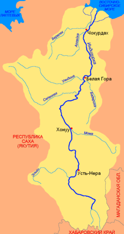
The Selennyakh (Russian: Селеннях) is a river in Sakha Republic, Russia. It is a left tributary of the Indigirka.
| Selennyakh Yakut: Силээннээх | |
|---|---|
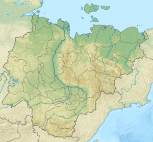 Location in the Sakha Republic, Russia | |
| Location | |
| Country | Russia |
| Physical characteristics | |
| Source | |
| ⁃ location | Confluence of the Kharga-Salaa and Nyamnya rivers |
| ⁃ coordinates | 69°28′40″N 137°40′34″E |
| ⁃ elevation | 420 m (1,380 ft) |
| Mouth | Indigirka |
⁃ coordinates | 67°50′41″N 144°54′51″E |
⁃ elevation | 29 m (95 ft) |
| Length | 796 km (495 mi) |
| Basin size | 30,800 km2 (11,900 sq mi) |
| Discharge | |
| ⁃ average | 180 cubic metres per second (6,400 cu ft/s) |
| Basin features | |
| Progression | Indigirka→ East Siberian Sea |
The length of the river is 796 kilometres (495 mi). The area of its drainage basin is 30,800 square kilometres (11,900 sq mi).[1]
Course
It originates in the north-west of the Chersky Range. The river flows southeastwards through the Moma-Selennyakh Depression which is bound in this area by the Burkat and Khadaranya ranges, and in the east by the Selennyakh Range, then the river flows across the Ust-Yansky District, where Sayylyk, the only inhabited place of its basin is found.
In its middle course the Selennyakh makes a wide bend northeastwards and then flows across the Aby Lowland in a roughly eastern direction untilit reaches the left bank of the Indigirka. The Selennyakh is frozen between October and May.[2]
According to the State Water Register of Russia, it is a part of the Lena basin district.[1] The average annual discharge in the mouth is 180 cubic metres per second (6,400 cu ft/s).
 Basin of the Indigirka |
References
- Река СЕЛЕННЯХ in the State Water Register of Russia (Russian)
- Article in Great Soviet Encyclopedia