Sciota, Illinois
Sciota /saɪˈoʊdə/ is a village in McDonough County, Illinois, United States. The population was 61 at the 2010 census.
Sciota Amicus, Clarkesville | |
|---|---|
Village | |
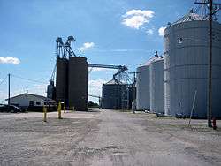 Farmers Elevator Company in Sciota, 2013. | |
| Etymology: Named for Sciota Township | |
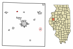 Location of Sciota in McDonough County, Illinois. | |
.svg.png) Location of Illinois in the United States | |
| Coordinates: 40°33′39″N 90°45′06″W | |
| Country | United States |
| State | Illinois |
| County | McDonough |
| Founded | 1867 |
| Government | |
| • Type | Village |
| Area | |
| • Total | 0.32 sq mi (0.83 km2) |
| • Land | 0.32 sq mi (0.83 km2) |
| • Water | 0.00 sq mi (0.00 km2) |
| Elevation | 758 ft (231 m) |
| Population (2010) | |
| • Total | 61 |
| • Estimate (2016)[2] | 58 |
| • Density | 180.69/sq mi (69.71/km2) |
| Time zone | UTC-6 (CST) |
| • Summer (DST) | UTC-5 (CDT) |
| ZIP Code(s) | 61475 |
| Area code(s) | 309 |
| FIPS code | 17-68198 |
| Wikimedia Commons | Sciota, Illinois |
Geography
Sciota is located at 40°33′39″N 90°45′06″W (40.5608731, -90.7517996) at an elevation of 758 ft (231 m).[3] According to the 2010 census, Sciota has a total area of 0.32 square miles (0.83 km2), all land.[4]
The village of Sciota lies in an area of prime farmland[5] with soil classified as Mollisols.[6]
Sciota is situated directly east of the headwaters of an unnamed tributary of Spring Creek, itself a tributary of the East Fork La Moine River.
Demographics
| Historical population | |||
|---|---|---|---|
| Census | Pop. | %± | |
| 1880 | 349 | — | |
| 1890 | 238 | −31.8% | |
| 1900 | 238 | 0.0% | |
| 1910 | 160 | −32.8% | |
| 1920 | 195 | 21.9% | |
| 1930 | 150 | −23.1% | |
| 1940 | 156 | 4.0% | |
| 1950 | 128 | −17.9% | |
| 1960 | 120 | −6.2% | |
| 1970 | 101 | −15.8% | |
| 1980 | 81 | −19.8% | |
| 1990 | 68 | −16.0% | |
| 2000 | 58 | −14.7% | |
| 2010 | 61 | 5.2% | |
| Est. 2016 | 58 | [2] | −4.9% |
| U.S. Decennial Census[7] | |||
As of the 2010 census,[8] there were 61 people, 26 households, and 12 families residing in the village. The racial makeup of the village was 100.00% White.
History
Sciota was laid out in September 1867 by William B. Clarke and was called Clarkesville in his honor. Another town in Illinois already had been named Clarksville (without the "e") so when the new town's post office was established on February 7, 1868, it was called Amicus.[9] This discrepancy between town name and post office name led the residents to change both names to Sciota, after Sciota Township in which the town lies (Sciota Township was named after the Scioto River in Ohio).[10] The Illinois General Assembly approved the name change on March 29, 1869.[11]
A Christian church was erected in 1869,[12] a Baptist church in 1871,[13] and a school building in 1872.[14]
In 1878, Sciota was the largest grain market in McDonough County.[15] At that time, the primary crops were corn and oats; now, the village is surrounded by fields of corn and soybeans.
A newspaper, The Sciota Sentinel, was published by H. C. Harl around 1895 but only one issue seems to have survived (October 17, 1895, no. 49).[16]
Transportation and infrastructure
Sciota is accessible by public roads from the south via McDonough County road East 800th Street (County Highway 13) which intersects with Illinois Route 9 1/2 mile south of the village. East 800th Street is called Buel Street within the village proper and extends north to the county line.
Sciota is served by the Keokuk Junction Railway.[17] As of January 2010, there were two rail sidings. There is one grade crossing protected by a pair of crossbucks with flashing lights and a mechanical warning bell (no gates).
The village received a state grant of $400,000 in 2001 to connect to the Good Hope water supply system and to build a water tower.[18] While Sciota has a water supply system, it does not have a sanitary sewer system; residents rely on septic systems for sewage disposal.
Notes
- "2016 U.S. Gazetteer Files". United States Census Bureau. Retrieved Jun 30, 2017.
- "Population and Housing Unit Estimates". Retrieved June 9, 2017.
- "Village of Sciota". Geographic Names Information System. United States Geological Survey.
- "G001 - Geographic Identifiers - 2010 Census Summary File 1". United States Census Bureau. Archived from the original on 2020-02-13. Retrieved 2015-12-25.
- Prime Farmland Distribution in Illinois Retrieved on January 2, 2010.
- Soil Orders of Illinois Retrieved on January 2, 2010.
- "Census of Population and Housing". Census.gov. Retrieved June 4, 2015.
- "Profile of General Population and Housing Characteristics: 2010". American FactFinder. U.S. Census Bureau. Archived from the original on February 12, 2020. Retrieved August 8, 2012.
- Callary (2008), p. 314. Retrieved on January 3, 2010.
- Clark (1878), p. 687.
- Illinois General Assembly (1869). Public Laws of the State of Illinois, Passed by the Twenty-sixth General Assembly, Convened January 4, 1869. Springfield, Ill.: Illinois Journal Printing Office, p. 269. Retrieved on January 3, 2010.
- Clark (1878), p. 538.
- Clark (1878), p. 569.
- Clark (1878), p. 430.
- Clark (1878), p. 688.
- WorldCat Record for The Sciota Sentinel Retrieved on January 6, 2010.
- "Keokuk Junction Railway Co". Pioneer Railcorp. Archived from the original on January 19, 2001. Retrieved January 2, 2010.
- "Governor Announces Community Water and Sewer Grants" (Press release). March 5, 2001. Archived from the original on June 11, 2011. Retrieved January 6, 2010.
References
Callary, E. (2008). Place Names of Illinois. Urbana, Ill.: University of Illinois Press. ISBN 978-0-252-03356-8.
Clark, S. J. (1878). History of McDonough County, Illinois: Its Cities, Towns and Villages, with Early Reminiscences, Personal Incidents and Anecdotes, and a Complete Business Directory of the County. Springfield, Ill.: D. W. Lusk. Internet Archive. Retrieved on January 2, 2010.
External links

Municipalities and communities of McDonough County, Illinois, United States | ||
|---|---|---|
| Cities | Map of Illinois highlighting McDonough County | |
| Villages | ||
| Townships | ||
| CDPs | ||
| Other unincorporated communities |
| |
| Ghost towns | ||
| Footnotes | ‡This populated place also has portions in an adjacent county or counties | |