Schimmelkopf
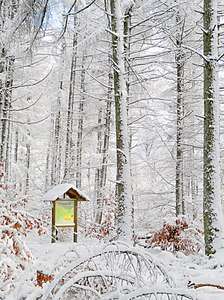
The Schimmelkopf or Weiskircher Höhe[3] is a mountain that rises in the Schwarzwalder Hochwald (part of the Hunsrück) on the boundary between the counties of Trier-Saarburg (Rhineland-Palatinate) and Merzig-Wadern (Saarland) and, at 694.8 m above sea level (NHN),[1][2] is the second highest peak in the German state of Saarland.
| Schimmelkopf | |
|---|---|
| (Weiskircher Höhe) | |
 | |
| Highest point | |
| Elevation | 694.8 m above sea level (NHN) (2,280 ft) [1][2] |
| Listing | second highest elevation in Saarland |
| Coordinates | 49°35′21″N 6°48′21″E |
| Geography | |
 Schimmelkopf | |
| Parent range | Schwarzwalder Hochwald |
Location
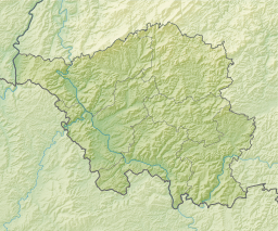
The Schimmelkopf rises in the southwestern part of the Schwarzwalder Hochwald along the northern state border of the Saarland. Its summit lies within the Saar-Hunsrück Nature Park, about 4.8 km north of Weiskirchen (Saarland), around 3.7 km southeast of Mandern and circa 3.3 km south of Waldweiler (both in Rhineland-Palatinate).
References
- Height of the Schimmelkopf according to Schimmelkopf (map and information) at Saarlandbilder.net
- Map services of the Federal Agency for Nature Conservation
- Horst Brausch et al.: Saarland (map, picture, word). Schroedel-Verlag, Brunswick, 2009, p. 5, ISBN 978-3-507-50544-5 (schoolbook)
External links
| Wikimedia Commons has media related to Schimmelkopf. |
- Schimmelkopf, map and info at saarlandbilder.net
This article is issued from Wikipedia. The text is licensed under Creative Commons - Attribution - Sharealike. Additional terms may apply for the media files.