Scheffau am Tennengebirge
Scheffau am Tennengebirge is a municipality in the Hallein district of Salzburg, Austria.
Scheffau am Tennengebirge | |
|---|---|
 | |
 Coat of arms | |
 Scheffau am Tennengebirge Location within Austria | |
| Coordinates: 47°35′30″N 13°12′40″E | |
| Country | Austria |
| State | Salzburg |
| District | Hallein |
| Government | |
| • Mayor | Friedrich Stubreiter (ÖVP) |
| Area | |
| • Total | 69.67 km2 (26.90 sq mi) |
| Elevation | 487 m (1,598 ft) |
| Population (2018-01-01)[2] | |
| • Total | 1,395 |
| • Density | 20/km2 (52/sq mi) |
| Time zone | UTC+1 (CET) |
| • Summer (DST) | UTC+2 (CEST) |
| Postal code | 5440 |
| Area code | 06244 |
| Vehicle registration | HA |
| Website | www.scheffau.salzburg.at |
Geography
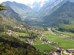
The municipality of Scheffau am Tennengebirge lies in the southern Tennengau of the Salzburger Land. The River Lammer flows through its territory. Its subordinate parishes are: Unterscheffau, Oberscheffau, Voregg, Wallingwinkl, Weitenau. Its Katastralgemeinden are Scheffau, Voregg und Weitenau.
The villages lies at the foot of the Tennengebirge mountain range that rises to a height of 2,300 m (7,500 ft) and, to the south, forms the boundary with Pongau. To the north the municipality includes part of the Ostern Group which is up to 1,600 m (5,200 ft) high. The centre of the municipality is in the Lammer valley in Unterscheffau and Oberscheffau.
References
- "Dauersiedlungsraum der Gemeinden Politischen Bezirke und Bundesländer - Gebietsstand 1.1.2018". Statistics Austria. Retrieved 10 March 2019.
- "Einwohnerzahl 1.1.2018 nach Gemeinden mit Status, Gebietsstand 1.1.2018". Statistics Austria. Retrieved 9 March 2019.

Scheffau am Tennengebirge, seen from the Mehlstein
This article is issued from Wikipedia. The text is licensed under Creative Commons - Attribution - Sharealike. Additional terms may apply for the media files.