Saumarez Parish, New Brunswick
Saumarez is a Canadian parish in Gloucester County, New Brunswick.[2] It was incorporated into the Regional Municipality of Grand Tracadie–Sheila on July 1, 2014.[3] Its population in the 2016 Census was 6,818.[1]
Saumarez | |
|---|---|
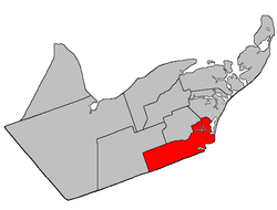 Location within Gloucester County, New Brunswick | |
| Coordinates: 47.5°N 64.94°W | |
| Country | |
| Province | |
| County | Gloucester |
| Established | 1814 |
| Area | |
| • Land | 326.78 km2 (126.17 sq mi) |
| Population (2016)[1] | |
| • Total | 6,818 |
| • Density | 20.9/km2 (54/sq mi) |
| • Pop 2011-2016 | |
| • Dwellings | 3,111 |
| Time zone | UTC-4 (AST) |
| • Summer (DST) | UTC-3 (ADT) |
Delineation
Saumarez Parish is defined in the Territorial Division Act[4] as being bounded:
- Bounded easterly by the Gulf of St. Lawrence and northerly, westerly and southerly by the following described bounds: Beginning at a point in the most western extremity of a twenty acre lot granted to F. Vienneau,[lower-alpha 1] situated at the easterly entrance of the Tracadie Lagoon;[lower-alpha 2] thence northwesterly in a direct line across said Lagoon to the mouth of LeBouthillier Brook; thence in a northwesterly direction following the various courses of said brook upstream to Highway 11[lower-alpha 3] leading from Tracadie[lower-alpha 4] to Pokemouche; thence in a direct line to the northeast angle of lot number one hundred and forty-five, granted to Dosite Landry, situated on the north side of the Saint-Isidore Road;[lower-alpha 5] thence in a westerly direction along the north limit of said lot to a point where the same is intersected by a direct line extending from the southeast angle of lot number one hundred and forty-four, granted to Dos. Landry, to the Southwest angle of lot number five, granted to Joseph Lavigne, in Range Six, Val-Doucet;[lower-alpha 6] thence in a southeasterly direction along said direct line to the southeast angle of aforesaid lot number one hundred and forty-four, granted to Dos. Landry; thence in a westerly direction along the south limit of said lot to a point where the same is intersected by the west bank or shore of Gaspereau Creek; thence in a southerly direction along said bank or shore to a point in the southern limit of lot number one hundred and forty-two, granted to M. Gottro; thence in a westerly direction along the southern limit of said lot and said limit of lot number three hundred and six, granted to George Savoy, and lot number three hundred and nine, granted to A. Basque, to a point in the eastern limit of lot number one, granted to T. Richard; thence in a southerly direction along said limit of said lot to the southeast angle of the same; thence in a westerly direction along the south limit of Range Six, Saint-Isidore [Settlement], to the northwest angle of lot number two hundred and eighty-nine, granted to Canute Arceno, situated in the Second Tier North of the Little Tracadie River; thence in a southerly direction along the west limit of said lot and said limit of lot number thirty, granted to Richard Arseneault, to a point in the north bank or shore of the aforesaid River; thence following the said bank or shore upstream to a point where the same is intersected by the south limit of Range Nine, Saint-Isidore; thence in a westerly direction along said limit of said Range and its western prolongation to a point in the Division line between Timber Block Numbers Three and Four, Range Eight; thence in a southerly direction along said Division line in Ranges Eight, Nine and Ten to a point in the Gloucester-Northumberland County County line; and thence in an easterly direction along said County line to the Gulf of St. Lawrence.
Governance
The entire parish is part of the Regional Municipality of Tracadie.
Communities
Parish population total does not include incorporated municipalities (in bold):
|
|
|
Demographics
Population
| Canada census – Saumarez Parish, New Brunswick community profile | |||
|---|---|---|---|
| 2016 | 2011 | 2006 | |
| Population: | 6,818 (-1.5% from 2011) | 6,920 (+1.3% from 2006) | 6,837 (-1.8% from 2001) |
| Land area: | 326.78 km2 (126.17 sq mi) | 326.78 km2 (126.17 sq mi) | 326.76 km2 (126.16 sq mi) |
| Population density: | 20.9/km2 (54/sq mi) | 21.2/km2 (55/sq mi) | 20.9/km2 (54/sq mi) |
| Median age: | 49.2 (M: 48.5, F: 49.8) | 45.9 (M: 45.5, F: 46.3) | 42.4 (M: 42.1, F: 42.6) |
| Total private dwellings: | 3,111 | 3,016 | 2,911 |
| Median household income: | $56,029 | $47,379 | $39,462 |
| References: 2016[10] 2011[11] 2006[12] earlier[13] | |||
| Historical Census Data - Saumarez Parish, New Brunswick | ||||||||||||||||||||||||||||||||
|---|---|---|---|---|---|---|---|---|---|---|---|---|---|---|---|---|---|---|---|---|---|---|---|---|---|---|---|---|---|---|---|---|
|
|
| ||||||||||||||||||||||||||||||
(A) adjustment due to boundary change [14][15][1] | ||||||||||||||||||||||||||||||||
Language
| Canada Census Mother Tongue - Saumarez Parish, New Brunswick[14] | ||||||||||||||||||
|---|---|---|---|---|---|---|---|---|---|---|---|---|---|---|---|---|---|---|
| Census | Total | French |
English |
French & English |
Other | |||||||||||||
| Year | Responses | Count | Trend | Pop % | Count | Trend | Pop % | Count | Trend | Pop % | Count | Trend | Pop % | |||||
2011 |
6,870 |
6,695 | 97.45% | 125 | 1.82% | 45 | 0.65% | 5 | 0.08% | |||||||||
2006 |
6,805 |
6,610 | 97.13% | 140 | 2.06% | 25 | 0.37% | 30 | 0.44% | |||||||||
2001 |
6,935 |
6,830 | 98.49% | 75 | 1.08% | 30 | 0.43% | 0 | 0.00% | |||||||||
1996 |
7,370 |
7,150 | n/a | 97.02% | 180 | n/a | 2.44% | 40 | n/a | 0.54% | 0 | n/a | 0.00% | |||||
See also
Footnotes
References
- "Census Profile, 2016 Census: Saumarez, Parish [Dissolved census subdivision], New Brunswick". Statistics Canada. Retrieved September 8, 2019.
- New Brunswick Provincial Archives - Saumarez Parish
- "Regional Municipality of Grand Tracadie-Sheila Regulation - Municipalities Act" (PDF) (PDF). Government of New Brunswick: Office of the Attorney General. March 28, 2014. p. 3. Retrieved September 17, 2014.
- "Territorial Division Act (R.S.N.B. 1973, c. T-3)". Government of New Brunswick website. Retrieved 25 August 2016.
- "Crown Grant Reference Map Viewer". GeoNB. Government of New Brunswick. Retrieved 25 August 2016.
- "Tracadie North Gully". Canadian Geographical Names. Natural Resources Canada. Retrieved 26 August 2016.
- "Baie de Tracadie". Canadian Geographical Names. Natural Resources Canada. Retrieved 26 August 2016.
- "No. 095" (PDF). 2015 Designated Highway Maps. Government of New Brunswick. Retrieved 25 August 2016.
- "Crown Grant Reference Map Viewer". GeoNB. Government of New Brunswick. Retrieved 25 August 2016.
- "2016 Community Profiles". 2016 Canadian Census. Statistics Canada. February 21, 2017. Retrieved 2019-09-08.
- "2011 Community Profiles". 2011 Canadian Census. Statistics Canada. July 5, 2013. Retrieved 2014-03-30.
- "2006 Community Profiles". 2006 Canadian Census. Statistics Canada. March 30, 2011. Retrieved 2014-03-30.
- "2001 Community Profiles". 2001 Canadian Census. Statistics Canada. February 17, 2012.
- Statistics Canada: 1996, 2001, 2006, 2011 census
- 2011 Statistics Canada Census Profile: Saumarez Parish, New Brunswick
Places adjacent to Saumarez Parish, New Brunswick | |
|---|---|
| Subdivisions |
|
|---|---|
| Cities | |
| Counties | |
| |
This article is issued from Wikipedia. The text is licensed under Creative Commons - Attribution - Sharealike. Additional terms may apply for the media files.