Sault Plat River
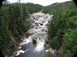
The Sault Plat River (French: Rivière du Sault Plat) is a river in the Côte-Nord region of Quebec, Canada. It empties into the Gulf of Saint Lawrence. The river is known for the dramatic evidence of glacial action, which has created large ridges and grooves in the bedrock. A section of the river cascading over these flutes is visible from Quebec Route 138.
| Sault Plat River Rivière du Sault Plat | |
|---|---|
 Geological site of the Rivière-du-Sault Plat | |
 | |
| Location | |
| Country | Canada |
| Province | Quebec |
| Region | Côte-Nord |
| RCM | Minganie |
| Physical characteristics | |
| Source | |
| ⁃ elevation | 244 metres (801 ft) |
| 2nd source | Lake Delaunay |
| ⁃ elevation | 90 metres (300 ft) |
| Mouth | Gulf of Saint Lawrence |
⁃ coordinates | 50.292778°N 65.443056°W |
⁃ elevation | 0 metres (0 ft) |
| Length | 24 kilometres (15 mi) |
| Basin size | 93.1 square kilometres (35.9 sq mi) |
| Discharge | |
| ⁃ location | Mouth |
| ⁃ average | 3.8 cubic metres per second (130 cu ft/s) |
| ⁃ minimum | 0.8 cubic metres per second (28 cu ft/s) |
| ⁃ maximum | 9.2 cubic metres per second (320 cu ft/s) |
Location
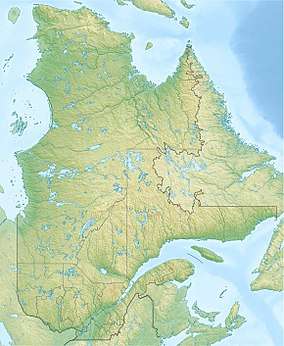
The Sault Plat River leaves Lake Delaunay at an elevation of 90 metres (300 ft) above sea level and flows south from there for 8 kilometres (5.0 mi) to the Gulf of Saint Lawrence.[1] The mouth of the river is in the municipality of Rivière-au-Tonnerre in Minganie Regional County Municipality.[2] The mouth is 50 kilometres (31 mi) west of the village of Rivière-au-Tonnerre and 70 kilometres (43 mi) east of the city of Sept-Îles.[3]
The elongated river basin runs from NNW to SSE with a length of 27 kilometres (17 mi) and maximum width of 5 kilometres (3.1 mi).[4] 7.9% of the basin is in the unorganized territory of Rivière-Nipissis in the Sept-Rivières Regional County Municipality. The remainder is in the Minganie Regional County Municipality, divided between the unorganized territory of Lac-Jérôme (67.5%) and the municipality of Rivière-au-Tonnerre (24.6%). It is to the west of the Tortue River watershed and to the east of the Bouleau River watershed.[3]
Name
The river was not named on the maps by Gustave Rinfret (1913) or Edgar Rochette (1927). The name first appeared officially in 1969 in the Répertoire géographique du Québec.[1]
Terrain
The upper part of the Sault Plat watershed is in a piedmont region that falls from an elevation of around 300 metres (980 ft) in the north down to 150 metres (490 ft) in the south. The piedmont region has rounded rocky hills, the highest being 533 metres (1,749 ft) in elevation. Below the piedmont is a coastal plain 5 kilometres (3.1 mi) wide that falls from an elevationof 150 metres (490 ft) in the north to an escarpment almost 100 metres (330 ft) high along the sea. The bedrock is magmatic, mostly an undeformed assembly of granite and pegmatite, with a band of migmatite more than 5 kilometres (3.1 mi) wide that runs from east to west across the center of the watershed. A thin and discontinuous layer of glacial till no more than 1 metre (3 ft 3 in) thick covers the bedrock. On the coastal plain the post-glacial Goldthwait Sea left deep marine clay and silt sediments, later covered by deltaic sandy sediments.[3]
A series of huge glacial flutes on the Sault Plat river bed near its mouth are visible from Quebec Route 138.[3] The Quebec government has designated this section of the river as an exceptional geological site (Site géologique exceptionnel). The river cascades through the large flutes and troughs dug out by glaciers during the last ice age, about 18,000 years ago. At one time the ice sheet was 3 kilometres (1.9 mi) thick. As the climate warmed the ice gradually withdrew to central Quebec, where it completely disappeared about 6,500 years ago. The flutes and grooves are elongated in the direction of the ice flow.[5]
Hydrology
The streams in the Sault Plat basin follow angular courses with straight stretches and sharp bends dictated by fractures in the bedrock. In the widest valleys the streams sometimes meander. The Sault Plat River, counting the section above Lake Delaunay, has a length of 24 kilometres (15 mi) and vertical drop of 244 metres (801 ft). The annual average flow at its mouth is estimated at 3.8 cubic metres per second (130 cu ft/s), with monthly averages that range from 0.8 to 9.2 cubic metres per second (28 to 325 cu ft/s).[4]
Lake Delauney, in the center of the watershed, is in an old U-shaped glacial valley. It is 8 kilometres (5.0 mi) long but narrow, covering 3.96 square kilometres (1.53 sq mi). In the north of the watershed Lake Boutereau covers 3.21 square kilometres (1.24 sq mi) and Lake Grace covers 1.34 square kilometres (0.52 sq mi). Both are irregular in shape. In total, water bodies cover 12.2% of the basin's area. Wetlands, mainly ombrotrophic bog on the coastal plain, cover 1.63% of the area.[4]
Environment
The Matamec weather station, 37 kilometres (23 mi) west of the Sault Plat River mouth, reports annual average temperature of 1.5 °C (34.7 °F) and annual average rainfall of 1,020 millimetres (40 in).[4] A map of the ecological regions of Quebec shows the river in sub-regions 6j-T and 6m-T of the east spruce/moss subdomain.[6] Forest cover consists of black spruce (Picea mariana) and balsam fir (Abies balsamea), with black spruce dominant on the coastal plain and mixed spruce/fir in the piedmont region. The only recorded fish species is brook trout (Salvelinus fontinalis).[4] Waterfowl congregate on the banks of the south of the river.[5] Reported species at the river mouth by a visitor in August 2019 included double-crested cormorant (Phalacrocorax auritus), northern gannet (Morus bassanus) and various gulls and ducks.[7]
Sources
- Embouchure Rivière du Sault-Plat, Cornell Lab of Ornithology, retrieved 2019-10-01
- Portrait du bassin versant du Sault Plat (PDF) (in French), OBV Duplessis, retrieved 2019-10-01
- Rivière du Sault Plat (in French), Commission de toponymie du Québec, retrieved 2019-10-01
- Rivière du Sault Plat (in French), Ressources naturelles Canada, retrieved 2019-10-01
- Saucier, J.-P.; Robitaille, A.; Grondin, P.; Bergeron, J.-F.; Gosselin, J. (2011), Les régions écologiques du Québec méridional (PDF) (map), 4 (in French), Ministère des Ressources naturelles et de la Faune, retrieved 2019-09-26
- Site géologique de la Rivière-du-Sault-Plat (PDF) (in French), Quebec, retrieved 2019-10-01