Saratoga, North Carolina
Saratoga is a town in Wilson County, North Carolina, United States. The population was 408 at the 2010 census.
Saratoga, North Carolina | |
|---|---|
 Saratoga, North Carolina Location within the state of North Carolina | |
| Coordinates: 35°39′13″N 77°46′35″W | |
| Country | United States |
| State | North Carolina |
| County | Wilson |
| Area | |
| • Total | 0.6 sq mi (1.7 km2) |
| • Land | 0.6 sq mi (1.7 km2) |
| • Water | 0.0 sq mi (0.0 km2) |
| Elevation | 118 ft (36 m) |
| Population (2010) | |
| • Total | 408 |
| • Estimate (2018)[1] | 403 |
| • Density | 680/sq mi (240/km2) |
| Time zone | UTC-5 (Eastern (EST)) |
| • Summer (DST) | UTC-4 (EDT) |
| ZIP code | 27873 |
| Area code(s) | 252 |
| FIPS code | 37-59340[2] |
| GNIS feature ID | 1022502[3] |
History
The Maj. James Scarborough House was listed on the National Register of Historic Places in 1982.[4]
Geography
Saratoga is located at 35°39′13″N 77°46′35″W (35.653630, -77.776493).[5]
According to the United States Census Bureau, the town has a total area of 0.6 square miles (1.6 km2), all of it land.
Demographics
| Historical population | |||
|---|---|---|---|
| Census | Pop. | %± | |
| 1880 | 81 | — | |
| 1890 | 102 | 25.9% | |
| 1900 | 123 | 20.6% | |
| 1910 | 136 | 10.6% | |
| 1940 | 292 | — | |
| 1950 | 366 | 25.3% | |
| 1960 | 409 | 11.7% | |
| 1970 | 391 | −4.4% | |
| 1980 | 381 | −2.6% | |
| 1990 | 342 | −10.2% | |
| 2000 | 379 | 10.8% | |
| 2010 | 408 | 7.7% | |
| Est. 2018 | 403 | [1] | −1.2% |
| U.S. Decennial Census[6] | |||
As of the census[2] of 2000, there were 379 people, 158 households, and 102 families residing in the town. The population density was 590.3 people per square mile (228.6/km²). There were 168 housing units at an average density of 261.7 per square mile (101.4/km²). The racial makeup of the town was 76.25% White, 19.79% African American, 3.43% from other races, and 0.53% from two or more races. Hispanic or Latino of any race were 5.80% of the population.
There were 158 households out of which 28.5% had children under the age of 18 living with them, 43.7% were married couples living together, 20.3% had a female householder with no husband present, and 35.4% were non-families. 32.3% of all households were made up of individuals and 17.1% had someone living alone who was 65 years of age or older. The average household size was 2.40 and the average family size was 2.95.
In the town, the population was spread out with 23.5% under the age of 18, 5.8% from 18 to 24, 29.6% from 25 to 44, 23.5% from 45 to 64, and 17.7% who were 65 years of age or older. The median age was 40 years. For every 100 females, there were 84.0 males. For every 100 females age 18 and over, there were 75.8 males.
The median income for a household in the town was $31,667, and the median income for a family was $37,750. Males had a median income of $33,125 versus $25,469 for females. The per capita income for the town was $15,317. About 8.2% of families and 13.1% of the population were below the poverty line, including 16.4% of those under age 18 and 8.7% of those age 65 or over.
References
- "Population and Housing Unit Estimates". Retrieved March 27, 2020.
- "U.S. Census website". United States Census Bureau. Retrieved 2008-01-31.
- "US Board on Geographic Names". United States Geological Survey. 2007-10-25. Retrieved 2008-01-31.
- "National Register Information System". National Register of Historic Places. National Park Service. July 9, 2010.
- "US Gazetteer files: 2010, 2000, and 1990". United States Census Bureau. 2011-02-12. Retrieved 2011-04-23.
- "Census of Population and Housing". Census.gov. Retrieved June 4, 2015.
External links
Municipalities and communities of Wilson County, North Carolina, United States | ||
|---|---|---|
| City | 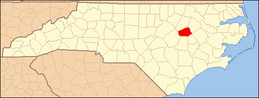 | |
| Towns | ||
| Unincorporated communities | ||
| Footnotes | ‡This populated place also has portions in an adjacent county or counties | |
| Authority control |
|
|---|