Santa Monica Air Line
The Santa Monica Air Line was an interurban air-line railroad operated by the Pacific Electric between Santa Monica and downtown Los Angeles which ran from 1909 to 1988[2] and has been reactivated as the Expo Line.
| Santa Monica Air Line | |||||||||||||||||||||||||||||||||||||||||||||||||||||||||||||||||||||||||||||||||||||||||||||||||||||||||||||||||||||||||||||||||||||||||||||||||||||||||||||||||||||||
|---|---|---|---|---|---|---|---|---|---|---|---|---|---|---|---|---|---|---|---|---|---|---|---|---|---|---|---|---|---|---|---|---|---|---|---|---|---|---|---|---|---|---|---|---|---|---|---|---|---|---|---|---|---|---|---|---|---|---|---|---|---|---|---|---|---|---|---|---|---|---|---|---|---|---|---|---|---|---|---|---|---|---|---|---|---|---|---|---|---|---|---|---|---|---|---|---|---|---|---|---|---|---|---|---|---|---|---|---|---|---|---|---|---|---|---|---|---|---|---|---|---|---|---|---|---|---|---|---|---|---|---|---|---|---|---|---|---|---|---|---|---|---|---|---|---|---|---|---|---|---|---|---|---|---|---|---|---|---|---|---|---|---|---|---|---|---|---|
| Overview | |||||||||||||||||||||||||||||||||||||||||||||||||||||||||||||||||||||||||||||||||||||||||||||||||||||||||||||||||||||||||||||||||||||||||||||||||||||||||||||||||||||||
| Type | Light rail | ||||||||||||||||||||||||||||||||||||||||||||||||||||||||||||||||||||||||||||||||||||||||||||||||||||||||||||||||||||||||||||||||||||||||||||||||||||||||||||||||||||||
| System | |||||||||||||||||||||||||||||||||||||||||||||||||||||||||||||||||||||||||||||||||||||||||||||||||||||||||||||||||||||||||||||||||||||||||||||||||||||||||||||||||||||||
| Locale | Los Angeles | ||||||||||||||||||||||||||||||||||||||||||||||||||||||||||||||||||||||||||||||||||||||||||||||||||||||||||||||||||||||||||||||||||||||||||||||||||||||||||||||||||||||
| Termini | Pacific Electric Building Santa Monica, California | ||||||||||||||||||||||||||||||||||||||||||||||||||||||||||||||||||||||||||||||||||||||||||||||||||||||||||||||||||||||||||||||||||||||||||||||||||||||||||||||||||||||
| Stations | 15 | ||||||||||||||||||||||||||||||||||||||||||||||||||||||||||||||||||||||||||||||||||||||||||||||||||||||||||||||||||||||||||||||||||||||||||||||||||||||||||||||||||||||
| Operation | |||||||||||||||||||||||||||||||||||||||||||||||||||||||||||||||||||||||||||||||||||||||||||||||||||||||||||||||||||||||||||||||||||||||||||||||||||||||||||||||||||||||
| Opened | May 26, 1909[1] | ||||||||||||||||||||||||||||||||||||||||||||||||||||||||||||||||||||||||||||||||||||||||||||||||||||||||||||||||||||||||||||||||||||||||||||||||||||||||||||||||||||||
| Closed | March 11, 1988 | ||||||||||||||||||||||||||||||||||||||||||||||||||||||||||||||||||||||||||||||||||||||||||||||||||||||||||||||||||||||||||||||||||||||||||||||||||||||||||||||||||||||
| Owner | Southern Pacific Railroad | ||||||||||||||||||||||||||||||||||||||||||||||||||||||||||||||||||||||||||||||||||||||||||||||||||||||||||||||||||||||||||||||||||||||||||||||||||||||||||||||||||||||
| Operator(s) | |||||||||||||||||||||||||||||||||||||||||||||||||||||||||||||||||||||||||||||||||||||||||||||||||||||||||||||||||||||||||||||||||||||||||||||||||||||||||||||||||||||||
| Technical | |||||||||||||||||||||||||||||||||||||||||||||||||||||||||||||||||||||||||||||||||||||||||||||||||||||||||||||||||||||||||||||||||||||||||||||||||||||||||||||||||||||||
| Line length | 16.88 | ||||||||||||||||||||||||||||||||||||||||||||||||||||||||||||||||||||||||||||||||||||||||||||||||||||||||||||||||||||||||||||||||||||||||||||||||||||||||||||||||||||||
| Track gauge | 1,435 mm (4 ft 8 1⁄2 in) standard gauge | ||||||||||||||||||||||||||||||||||||||||||||||||||||||||||||||||||||||||||||||||||||||||||||||||||||||||||||||||||||||||||||||||||||||||||||||||||||||||||||||||||||||
| Electrification | Overhead lines | ||||||||||||||||||||||||||||||||||||||||||||||||||||||||||||||||||||||||||||||||||||||||||||||||||||||||||||||||||||||||||||||||||||||||||||||||||||||||||||||||||||||
| |||||||||||||||||||||||||||||||||||||||||||||||||||||||||||||||||||||||||||||||||||||||||||||||||||||||||||||||||||||||||||||||||||||||||||||||||||||||||||||||||||||||
Route
Beginning at the rear of the Pacific Electric Building at 6th and Main streets in downtown Los Angeles, the Air Line crossed over Los Angeles street on a viaduct to reach San Pedro street where it turned south on the same tracks used by the Bellflower/Santa Ana, Newport Beach, Redondo Beach, and Long Beach PE lines. It turned from San Pedro onto 9th street and ran to private right of way close to what is now Long Beach Boulevard and the present day Blue Line. At 25th Street and Long Beach Boulevard at what was called Amoco (American Olive Company) Junction,[3], the Air Line left the four track Watts main line and went west on a single track private right-of-way line running within Exposition Boulevard toward Santa Monica Beach. The currently abandoned section between the Blue Line tracks and USC is the primary difference between today's Expo Line and Air Line routes.
- Stops on the line in 1911, with miles from LA:
Major depots in bold.
- Start in Los Angeles 0.00
- Nevin 2.62
- Hooper 3.05
- San Pedro Street 3.77
- Jefferson 4.18
- Grand Avenue 4.54
- University 5.40
- 11th Avenue 7.68
- Sentous 10.04
- Culver Junction 11.16 (Venice Blvd and Culver Blvd)
- Palms 12.20
- Talamantes 13.73
- Home Junction 14.87
- Soldiers' Home 15.87
- Bergamot 15.25
- Sunset 16.18
- Santa Monica 16.88
- Tool House 17.54
- Ocean Park 19.20
- Inglewood 26.43
History
The line was built in 1875 as the steam-powered Los Angeles and Independence Railroad, intended to bring mined ore to ships in Santa Monica harbor's Long Wharf and as a passenger excursion train to the beach. Purchased by Southern Pacific Railroad, it was leased to the Los Angeles Pacific Railroad for electric passenger and light freight use in 1909. Pacific Electric bought the line in 1911, along with all the other lines owned by Los Angeles Pacific. The Santa Monica harbor Long Wharf was closed to shipping traffic in 1913.[4][5][6]
Service decline and end
With sparse population along much of the route, service on the Air Line was reduced as early as 1924, with passenger cars running only during rush hours. At that point most passengers traveled to Santa Monica on a different rail line which ran primarily on Santa Monica Boulevard.
Passenger service on the Air Line was discontinued on September 30, 1953; however, freight service remained. Because the Air Line route was also connected to the Santa Monica Boulevard line via tracks on Sepulveda Boulevard, it was the only way for freight trains to reach West Los Angeles, Beverly Hills and Hollywood warehouses (usually at night due to city regulations).
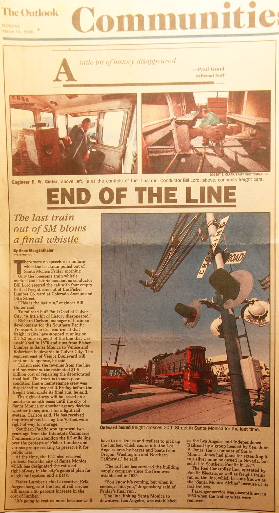
As the use of rail for transporting freight gradually declined, the tracks along Santa Monica and Sepulveda boulevards were removed and service became sparse. The tracks alongside Exposition Park occasionally also served a special purpose to hold circus trains throughout the 1980s and to store various companies' passenger cars during the 1984 Olympic Games. The final freight run was from Fisher Lumber in Santa Monica in the morning of Friday, March 11, 1988.[7]
After abandonment, ownership was maintained by Southern Pacific, which leased various portions of the land for semi-permanent structures. By the mid-1990s parking lots, storage facilities and some retail buildings had almost completely covered the tracks west of Sepulveda Boulevard - with unused signal cantilevers and crossing gates being the only clue to its former existence. East of Sepulveda Boulevard, tracks, bridges and tunnels remained intact but overgrown.
A lone Southern Pacific Railroad boxcar was marooned on a freight siding which once serviced a warehouse at 10151 National Boulevard, originally the Great Western Biscuit Company and later the publications division of Douglas Aircraft Company. In 2005 the building was leveled and the boxcar cut apart and removed to make way for Price Self-Storage.[8]
Reactivation
The right-of-way was purchased by a predecessor to Los Angeles Metro. Track replacement and various construction tasks began in 2006, and the first phase of the "Expo Line" from downtown Los Angeles to Culver City opened in April, 2012. Service for the second phase to Santa Monica began on May 20, 2016.
While most parts of the Air line have been replaced in reconstruction, two major structures from the Air line passenger service days remain: The steel bridge over National Boulevard was deemed structurally sound and was used again in conjunction with a new twin bridge for a second track; and the tunnel under the Santa Monica Freeway, which began construction just as passenger service was being discontinued.
See also
References
- R.P. Sherman, Air Line Flyer Service Put On To Santa Monica, Los Angeles Herald, May 26, 1909, page 5
- "Los Angeles Herald 8 April 1888 — California Digital Newspaper Collection". ucr.edu.
- en.wikipedia.org/wiki/Amoco_Junction
- , SANTA MONICA GETS NEW TRAIN SERVICE BOARD OF TRADE SECURES ADDED FLYERS, Los Angeles Herald, August 16, 1908, page 7
- "Los Angeles Herald 25 June 1904 — California Digital Newspaper Collection". ucr.edu.
- "Pacific Electric Santa Monica Air Line". erha.org.
- Morgenthaler, Anne, END OF THE LINE—The last train out of SM blows a final whistle, The Santa Monica Outlook, March 14, 1988
- George Garrigues, Los Angeles's The Palms Neighborhood, Arcadia Press, 2009, pages 30 and 32 ISBN 978-0-7385-6993-2
Website discussion of route with photographs of equipment in 1930s-40s photographs of the PE's Santa Monica Air Line: https://la.curbed.com/2015/7/30/9935072/red-car-air-line-expo-line-history
External links
- Essay on the Santa Monica Air Line at Abandonedrails.com
- Information on the wigwag cantilevers at Trainweb.org/dansrailpix
- Santa Monica Air Line history page at erha.org
- Historic photos ca. 1953 of the final days of passenger service on the Santa Monica Air Line
- Large Set of Construction Photos of the Project
| Routes |
|  | ||||||
|---|---|---|---|---|---|---|---|---|
| History | ||||||||
| Infrastructure | ||||||||
| Predecessors |
| |||||||
| Connecting services | ||||||||
| Successors | ||||||||
| Legacy | ||||||||