Sangerhausen
Sangerhausen (German pronunciation: [zaŋɐˈhaʊzn̩]) is a town in Saxony-Anhalt, Germany, capital of the district of Mansfeld-Südharz. It is situated southeast of the Harz, approx. 35 kilometres (22 miles) east of Nordhausen, and 50 km (31 mi) west of Halle (Saale). About 31,000 people live in Sangerhausen.
Sangerhausen | |
|---|---|
 Sangerhausen | |
 Coat of arms | |
Location of Sangerhausen within Mansfeld-Südharz district 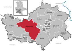 | |
 Sangerhausen  Sangerhausen | |
| Coordinates: 51°28′0″N 11°18′0″E | |
| Country | Germany |
| State | Saxony-Anhalt |
| District | Mansfeld-Südharz |
| Government | |
| • Mayor | Sven Strauß (SPD) |
| Area | |
| • Total | 207.64 km2 (80.17 sq mi) |
| Elevation | 154 m (505 ft) |
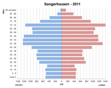
| Population (2018-12-31)[1] | |
| • Total | 26,297 |
| • Density | 130/km2 (330/sq mi) |
| Time zone | CET/CEST (UTC+1/+2) |
| Postal codes | 03464, 034656 (Großleinungen), 034658 (Breitenbach, Horla, Wolfsberg), 034775 (Wippra) |
| Dialling codes | 03464 |
| Vehicle registration | MSH, EIL, HET, ML, SGH |
| Website | www.sangerhausen.de |
History
![]()
![]()

![]()
![]()
![]()
![]()
![]()
![]()
![]()
Sangerhausen is one of the oldest towns in the historical region of Saxony-Anhalt, being first mentioned in a document created between 780 and 802 in Fulda Abbey.
Sangerhausen is mentioned as the tithable place Sangerhus in Friesenfeld in the Hersfeld Tithe Register, created between 881 and 899.
It is mentioned in a document of 991 as appertaining to the estates of the emperor, as part of Memleben Abbey.
By marriage it passed to the landgrave of Thuringia, and after 1056 it formed for a while an independent country. Having been again part of Thuringia, it fell in 1249 to Meissen, and in 1291 to Brandenburg. In 1372 it passed to the Electorate of Saxony and formed a portion of that territory until 1815, when it became a part of the Prussian Province of Saxony.
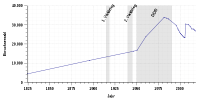
Historical Population
|
|
* After annexation of neighboring districts
** Population of Sangerhausen town in brackets
Municipality

.JPG)
The municipality of Sangerhausen currently includes the town itself plus 14 outlying villages, also called (in German) Ortschafte or Ortsteile. These are Breitenbach, Gonna, Grillenberg, Großleinungen, Horla, Lengefeld, Morungen, Oberröblingen, Obersdorf, Riestedt, Rotha, Wettelrode, Wippra and Wolfsberg.
In 1994, the town of Sangerhausen, at that time still an independent municipality, became part of the so-called Verwaltungsgemeinschaft Sangerhausen, a municipal association consisting of Sangerhausen itself and the two villages/municipalities Edersleben and Oberröblingen. On 29 April 2000 Edersleben left for the Verwaltungsgemeinschaft Helme. On 1 January 2005 the villages/municipalities Gonna, Grillenberg, Horla, Lengefeld, Morungen, Obersdorf, Pölsfeld, Rotha and Wettelrode joined the association from the Verwaltungsgemeinschaft Südharz which was dissolved. Six months later, on 3 July 2005 Pölsfeld left for the Verwaltungsgemeinschaft Allstedt-Kaltenborn.
On 1 Oct. 2005 the Verwaltungsgemeinschaft Sangerhausen, consisting then of 10 municipalities was dissolved and turned into the single town/municipality Sangerhausen; which meant that the 9 villages were truly annexed. On the same date Breitenbach, Großleinungen and Wolfsberg also joined, coming from the municipal association Roßla-Südharz. On 1 December 2005 Riestedt followed, coming from the Verwaltungsgemeinschaft Allstedt-Kaltenborn. Finally, Wippra was incorporated on 1 January 2008, coming from the Verwaltungsgemeinschaft Wipper-Eine.
Main sights
- Altes Rathaus ("Old Town Hall"), erected in 1431-1437 after a previous edifice burned down in 1358.
- Church of St. Mary (Marienkirche), built in 1350 in Gothic style
- Church of St. James (Jakobikirche, 1457-1542), a late Gothic hall edifice with a nave and three aisles. It has a 61 m-high, slightly tilting bell tower with a Baroque cover. The interior has a rich decoration painted by Georg Bottschild in 1665, while the choir stalls and the high altar are from an Augustinian monastery closed in 1539. It also houses numerous tombs and effigies. Johann Sebastian Bach applied here in 1702 for the post of organist, but the job went to Johann Augustin Kobelius.
- Church of St. Ulrich (Ulrichkirche), one of the most interesting Romanesque edifices in Germany. It is a basilica built in 1116-1123, with a bell tower added in the 15th century. It has a nave and two aisles with groin vault. The eastern part has five apses.
- The Altes Schloss ("Old Castle"), built by the lords of Meissen. Only a tower remains. The New Palace or Neues Schloss was built by Kaspar Tryller, minister of Finances of the Electorate of Saxony, from 1612 to 1622. It is a Renaissance style, and now houses the county court.
In the vicinity are the famous Kyffhäuser Monument and the Barbarossa Cave, the only anhydrite cave in Europe which can be visited by tourists. Sangerhausen is also home to the Europa-Rosarium, the largest collection of roses in the world, created in 1903.
Transport links
Sangerhausen station lies on the Halle–Hann. Münden railway and the Sangerhausen–Erfurt railway.
International relations
Twin towns — sister cities
Sangerhausen is twinned with:[3]


Sons and daughters of the town
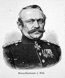
- Julius von Bose (1809-1894), Prussian general of the infantry
- Andreas Knebel (born 1960), athlete
- Thomas Liese (born 1968), cyclist
- Manfred Möck (born 1959), actor
- Norbert Nachtweih (born 1957), football player
- Werner Rothmaler (1908-1962), botanist and professor at the University of Greifswald
- Einar Schleef (1944-2001), director and writer
- Werner Stock (1903-1972), actor
- Annekatrin Thiele (born 1984), rower
Sources

References
- "Bevölkerung der Gemeinden – Stand: 31. Dezember 2018" (PDF). Statistisches Landesamt Sachsen-Anhalt (in German).
- Zensusdatenbank
- "Partnerstädte". sangerhausen.de (in German). Sangerhausen. Retrieved 2019-11-28.
Further reading
- Makos, Adam (2019). Spearhead (1st ed.). New York: Ballantine Books. p. 305. ISBN 9780804176729. LCCN 2018039460. OL 27342118M.
External links
| Wikimedia Commons has media related to Sangerhausen. |
Towns and municipalities in the district of Mansfeld-Südharz | ||
|---|---|---|
Coat of arms | ||
| Authority control |
|
|---|