Sandwip
Sandwip (Bengali: সন্দ্বীপ) is an island along the south eastern coast of Bangladesh in the Chittagong District. Also spelled Sandvip, the transliteration of the name would in fact be Shondip. It is part of the sub-district of Sandwip Upazila.
| Native name: সন্দ্বীপ | |
|---|---|
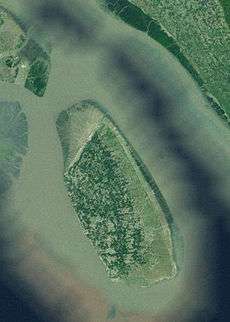 Satellite view of Sandwip | |
 Sandwip | |
| Geography | |
| Location | Bay of Bengal |
| Coordinates | 22°29′N 91°29′E |
| Adjacent bodies of water | Bay of Bengal |
| Total islands | 3 |
| Major islands | 1 |
| Area | 762.42 km2 (294.37 sq mi) |
| Length | 50 km (31 mi) |
| Width | 5–15 km (3.1–9.3 mi) |
| Administration | |
| District | Chattagram District |
| Demographics | |
| Demonym | Sandwipi |
| Population | 450,000[1] (2016) |
| Pop. density | 439/km2 (1,137/sq mi) |
Description

It is at the estuary of the Meghna River on the Bay of Bengal and separated from the Chittagong coast by Sandwip Channel. It has a population of nearly 350,000. There are fifteen wards, 62 mahallas and 34 villages on Sandwip Island. The island is 50 kilometres (31 mi) long and 5–15 kilometres (3.1–9.3 mi) wide. It is at the north-east side of the Bay of Bengal, near the main port city of Chittagong. It is bounded by Companiganj on the north, Bay of Bengal on the south, Sitakunda and Mirsharai, and Sandwip Channel on the east, Noakhali Sadar, Hatiya and Meghna estuary on the west.[2]
Etymology
There are several theories to the origin of the name Sandwip (pronounced Shondip) among the locals. Some say that 12 awlia from Baghdad travelling to Chittagong discovered this island in the middle of the ocean and found no people, so they defined it as "Shunno Dip" and which eventually became "Shondip". And another group argues that "Sandwip" is named after Bakhorganj historian Mr. Beverage's "Shom Dip".[1] some of old people says that "sandwip" was come from sand means (bali),heap(get together of bali) Some scholars have suggested that Portuguese people called it "Sandheep" (Hasan, 1999). Je the Baras marked it as "Sundina" in his map (1550). Candel Broke mentioned it as ‘Sundiva’ in his map (1660). Major Ranel mentioned it as ‘Sundeep’ in his map.[2]
History
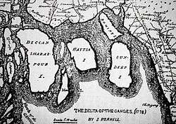
Sandwip Island in Bangladesh has a great historical legacy. The island itself is about 3000 years old[3] and it has been ruled by many different people over the centuries, including Delwar Khan. It was a Portuguese and Arakanese pirate stronghold during the 17th century and even today some of the architecture on the island reflects this part of the island's history. At that time the Arakanese ruled part of Burma (Myanmar), Chittagong including Sandwip. Sandwip was under the control of Arakanese leader Delawar Khan at that time. Delawar Khan was attacked in by Mughal Emperor Aurangzeb in 1665. Delawar Khan was arrested and was taken prisoner in Dhaka. Delawar died while in prison. However, the governor of Bengal saw fit to put an end to this in 1665 as part of attempts to restore Mughal control over the island. Under British rule its location proved to be a bit of an administrative problem. Today it is part of Bangladesh. It is supposed that Sandwip was connected with Chittagong original land and disconnected by natural disasters.[2]
Tansi reported on Lower Gangas (150) in which he included Sandwip. Sandwip is mentioned at The Baros Map (1560). Cesar Fredarich visited in Sandwip in 1565 and noted it as old island. Parcuch described 300-year-old mosque in this area (1620). Sanchan the Abevel mentioned Sandwip in his drawing map and he also mentioned Vulua, Bengal, Chattagram and Dhaka with it. Sri Rajkumar Chakrabarty mentioned in his History of Sandwip about 400 or 500 years old plants (1923). It is also found in The Anvel Curt's drawing map (1752).[2]
Agriculture
Agriculture is the main occupation of many people on the island. They cultivate paddy, jute, potato, betel leaf, betel nut, sugarcane, radish, tomato, brinjal, cauliflower, sweet potato, carrot, etc. They cultivate fruit including water melon, mango, jackfruit, banana, papaya, guava, kul, and date.
Ecology
Sandwip Island has been formed by silt deposits from the estuary of the Meghna river. This makes it an incredibly fertile island – something which the people of the island have been exploiting for years. Large crops of rice, dal, vegetables, coconuts, battle leave and wheat have all been grown on the island at some point in its history. Today the main crops are melons, mangos, pineapples, gaab, jam and coconut.
Natural disaster
In the years 1825, 1876, 1985, 1991 Sandwip was affected by devastating cyclones & tornadoes. On 29 April 1991, the most damaging storm affected the island. The death toll was about 40,000, and 80% of the houses in Sandwip were destroyed. The velocity of the cyclone was 225 km/h (140 mph).[4]
Famous persons
Muzaffar Ahmed (politician) - Bengali politician, journalist and communist activist, popularly known as "Kakababu".
Belal Muhammad- One of the founders of the Swadhin Bangla Betar Kendra.
Abdul Hakim (poet)- A poet in medieval Bengal. He wrote several epics verses in Bengali and also translated some from Persian manuscript.
Master Anwar Hossain-Founder of Santoshpur High School and Uttar Santoshpur Primary School which is now a govt. School. He was a very active Social worker.
Gallery
| Wikimedia Commons has media related to Sandwip. |
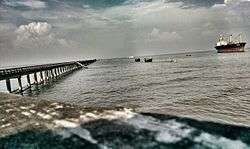
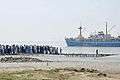 Ships Wharf, Sandwip
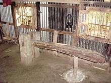 Dheki (husking pedal) once was very common in houses of Sandwip
 Kakataruya
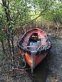
References
- "Sandwip Upazila (সন্দ্বীপ উপজেলা)". Chittagong. 26 May 2011. Retrieved 7 November 2012.
- "Sandwip Island". Ebbd.info. Retrieved 7 November 2012.
- Noakhali District Gazetters
- "The Yellow page of Sandwip - প্রাকৃতিক দূর্যোগ". Sandwip-uttaran.org. Archived from the original on 26 November 2013. Retrieved 7 November 2012.
External links
- Sandwip Chittagong, Sandwip Chittagong, Bangladesh