Sandwich Range
The Sandwich Range is located in the White Mountains of New Hampshire in the United States, north of the Lakes Region and south of the Kancamagus Highway. Although the range is not outstanding for its elevation, it is very rugged and has excellent views of the surrounding lakes, mountains, and forests.
| Sandwich Range | |
|---|---|
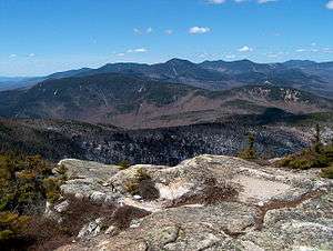 The Sandwich Range as seen looking west from Mount Chocorua. Summits include Mount Paugus (mid-foreground), Mount Whiteface (horizon mid-left), Mount Passaconaway (horizon center), and Mount Tripyramid (horizon mid-right). | |
| Highest point | |
| Peak | Mount Tripyramid |
| Elevation | 4,170 ft (1,270 m) |
| Coordinates | 43°58.40′N 71°26.57′W |
| Geography | |
| Country | United States |
| State | New Hampshire |
| Parent range | White Mountains, Appalachian Mountains |
The Sandwich Range extends east-west about 30 miles from Conway, New Hampshire on the Saco River to Campton on the Pemigewasset River. The Kancamagus Highway runs along the north side of the mountains, from Conway to North Woodstock. The highest peak in the range is Mount Tripyramid, with an elevation of 4,170 feet (1,270 m).[1]
The east part of the range drains by various streams into the Saco River and thence into the Atlantic Ocean at Saco, Maine. The west part drains into the East Branch Pemigewasset River and Mad River, thence into the Pemigewasset, Merrimack and into the sea at Newburyport, Massachusetts.
The range shares its name with the town of Sandwich, situated at the range's western end. To the south are the Ossipee Mountains, and the ancient volcanic ring dike of the Mt. Shaw massif.
Summits
The range's summits include, among others:[2]
- Mount Chocorua 3,490 ft (1,060 m)
- Mount Kancamagus 3,763 ft (1,147 m)
- Mount Passaconaway 4,043 ft (1,232 m) *
- Mount Paugus 3,198 ft (975 m)
- Mount Tripyramid 4,170 ft (1,270 m) *
- Mount Whiteface 4,020 ft (1,230 m) *
- Mount Wonalancet 2,760 ft (840 m)
- Sandwich Mountain 3,993 ft (1,217 m)
- The Sleepers 3,880 ft (1,180 m)
The summits marked with an asterisk (*) are included on the Appalachian Mountain Club's peak-bagging list of "Four-thousand footers" in New Hampshire.
See also
- List of mountains in New Hampshire
- Mount Shaw
- White Mountain National Forest
References
- Appalachian Mountain Club, White Mountain Guide, 26th ed. (1998), pp. 313-314
- U.S. Geological Survey 7½-minute topographic maps - Mount Chocorua, Mount Tripyramid, Waterville Valley, Mount Carrigain, and Mount Osceola quadrangles