Samdrup Jongkhar District
Samdrup Jongkhar District (Dzongkha: བསམ་གྲུབ་ལྗོངས་མཁར་རྫོང་ཁག་; Wylie: Bsam-grub Ljongs-mkhar rdzong-khag) is one of the 20 dzongkhags (districts) comprising Bhutan. The dominant languages of the district are Tshangla (Sharchopkha) in the north and west, and Nepali in the east.
Samdrup Jongkhar district བསམ་གྲུབ་ལྗོངས་མཁར་རྫོང་ཁག | |
|---|---|
District | |
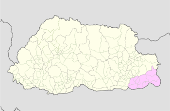 Map of Samdrup Jongkhar District in Bhutan | |
| Country | Bhutan |
| Headquarters | Samdrup Jongkhar |
| Area | |
| • Total | 1,878 km2 (725 sq mi) |
| Population (2017) | |
| • Total | 35,079 |
| • Density | 19/km2 (48/sq mi) |
| Time zone | UTC+6 (BTT) |
| HDI (2017) | 0.619[1] medium · 6th |
| Website | www |
Administrative divisions
Samdrup Jongkhar District is divided into eleven village groups (or gewogs):[2]
Protected areas
Samdrup Jongkhar contains protected areas. Southeastern Samdrup Jongkhar District (the gewogs of Langchenphu, Pemathang, Samrang and Serthi) contains Khaling Wildlife Sanctuary, which is connected via biological corridors to Sakteng Wildlife Sanctuary to the north (Trashigang District) and Royal Manas National Park to the west (several districts). A small portion of northern Lauri Gewog is part of the Sakteng Wildlife Sanctuary.[2][3]
See also
References
- "Sub-national HDI - Area Database - Global Data Lab". hdi.globaldatalab.org. Retrieved 2018-09-13.
- "Chiwogs in Samdrup Jongkhar" (PDF). Election Commission, Government of Bhutan. 2011. Archived from the original (PDF) on 2011-10-02. Retrieved 2011-07-28.
- "Parks of Bhutan". Bhutan Trust Fund for Environmental Conservation online. Bhutan Trust Fund. Archived from the original on 2011-07-02. Retrieved 2011-03-26.