Salmas County
Salmas County (Persian: شهرستان سلماس) is a county in West Azarbaijan Province in Iran.[2] The capital of the county is Salmas. At the 2006 census, the county's population was 180,708 .[3] The county is subdivided into two districts: the Central District and Kuhsar District. The county has two cities: Salmas and Tazeh Shahr. A few thousand Armenians live in the district, and comprise the second largest population of minorities in the Province after Urmia County.
Salmas County | |
|---|---|
| Salmas County | |
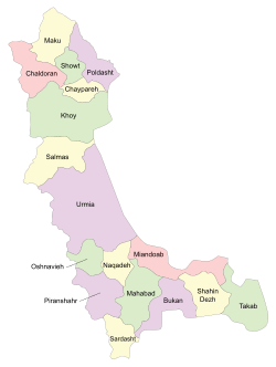 Counties of West Azerbaijan Province | |
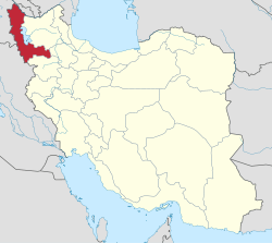 Location of West Azerbaijan Province in Iran | |
| Coordinates: 38°11′N 44°44′E | |
| Country | |
| Province | West Azerbaijan |
| Capital | Salmas |
| Bakhsh (Districts) | Central District, Kuhsar District |
| Population (2016) | |
| • Total | 196,547 |
| • Rank | 90, Iran[1] |
| Demonym(s) | Salmasian |
| Time zone | UTC+3:30 (IRST) |
| • Summer (DST) | UTC+4:30 (IRDT) |
| Salmas County can be found at GEOnet Names Server, at this link, by opening the Advanced Search box, entering "9205911" in the "Unique Feature Id" form, and clicking on "Search Database". | |
Administrative divisions
Salmas County is divided into two districts (بخش):
- Central District (Markazi):
- Kuhsar District: three dehdars: Chehriq, Shepiran and Shenatal
Demographics
| Salmas County Historical Population | ||
|---|---|---|
| Year | Population | ±% |
| 1956 | 57,961 | — |
| 1966 | 70,824 | +22.2% |
| 1976 | 87,700 | +23.8% |
| 1986 | 127,891 | +45.8% |
| 1996 | 156,558 | +22.4% |
| 2006 | 183,381 | +17.1% |
| 2011 | 192,591 | +5.0% |
| 2016 | 196,547 | +2.1% |
| 2021 | N/A | — |
| Note: The data presented of 1976 and earlier (1956-1976) are from the censuses before Iranian Revolution and the data of 1986 and later (1986-2016) are from the censuses after it. The population of the county for the census 1956 is approximated by about 440% of Salmas's populations censused at the same year. Sources: "Population and Housing Census". Statistical Center of Iran. (used for censuses of 2006 and later), "Population of Salmas County". Salmas Weblog. (used for census of 1996), "Location and Geography of the City". Salmas County Municipality. (used for censuses 1966-1986), "An Analysis to the Urban System of West Azerbaijan Province During the Years 1956 till 2006". Urban Ecology Researches. (used in approximate calculation of the population for the census of 1956). | ||
References
- http://yaftenews.ir/important-news/17464-sarshomarii96.html
- اطلس گیتاشناسی استانهای ایران [Atlas Gitashenasi Ostanhai Iran] (Gitashenasi Province Atlas of Iran Archived 2007-05-22 at the Wayback Machine)
- "Census of the Islamic Republic of Iran, 1385 (2006)". Islamic Republic of Iran. Archived from the original (Excel) on 2011-11-11.
| Capital |  | |
|---|---|---|
| Counties and cities | ||
| Tourism | ||
| Places | ||
| Capital | |||||||||||||||||
|---|---|---|---|---|---|---|---|---|---|---|---|---|---|---|---|---|---|
| Districts |
| ||||||||||||||||
This article is issued from Wikipedia. The text is licensed under Creative Commons - Attribution - Sharealike. Additional terms may apply for the media files.