Saint-Loup-Lamairé
Saint-Loup-Lamairé is a commune in the Deux-Sèvres department in western France.
Saint-Loup-Lamairé | |
|---|---|
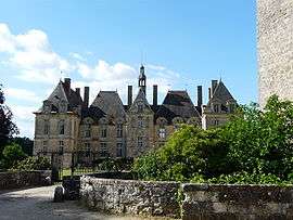 The Château of Saint-Loup-sur-Thouet | |
Coat of arms | |
Location of Saint-Loup-Lamairé 
| |
 Saint-Loup-Lamairé  Saint-Loup-Lamairé | |
| Coordinates: 46°47′21″N 0°09′50″W | |
| Country | France |
| Region | Nouvelle-Aquitaine |
| Department | Deux-Sèvres |
| Arrondissement | Parthenay |
| Canton | Le Val de Thouet |
| Intercommunality | Val du Thouet |
| Government | |
| • Mayor (2008–2014) | Jacques Boquier |
| Area 1 | 21.80 km2 (8.42 sq mi) |
| Population (2017-01-01)[1] | 986 |
| • Density | 45/km2 (120/sq mi) |
| Time zone | UTC+01:00 (CET) |
| • Summer (DST) | UTC+02:00 (CEST) |
| INSEE/Postal code | 79268 /79600 |
| Elevation | 74–162 m (243–531 ft) (avg. 130 m or 430 ft) |
| 1 French Land Register data, which excludes lakes, ponds, glaciers > 1 km2 (0.386 sq mi or 247 acres) and river estuaries. | |
The commune was formed in 1974 by the merger of two former communes: Saint-Loup-sur-Thouet and Lamairé.
As indicated by its name, the village of Saint-Loup-sur-Thouet is situated on the River Thouet. The long-distance walking route GR 36 also passes through, en route from Ouistreham, on the coast of the English Channel, to Bourg-Madame, on the border with Spain.[2][3]
See also
- Théophane Vénard, born in Saint-Loup-sur-Thouet
- Communes of the Deux-Sèvres department
References
- "Populations légales 2017". INSEE. Retrieved 6 January 2020.
- "France for Walkers - The Thouet Valley". France Magazine. Retrieved 2008-06-04.
- Carte de Promenade - 33 - Cholet Niort. Institut Geographique National.
| Wikimedia Commons has media related to Saint-Loup-Lamairé. |
| Authority control |
|
|---|
This article is issued from Wikipedia. The text is licensed under Creative Commons - Attribution - Sharealike. Additional terms may apply for the media files.