Saint-Hippolyte-le-Graveyron
Saint-Hippolyte-le-Graveyron is a commune in the Vaucluse department in the Provence-Alpes-Côte d'Azur region in southeastern France.
Saint-Hippolyte-le-Graveyron | |
|---|---|
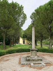 Column with a cross at the centre of the village | |
.svg.png) Coat of arms | |
Location of Saint-Hippolyte-le-Graveyron 
| |
 Saint-Hippolyte-le-Graveyron  Saint-Hippolyte-le-Graveyron | |
| Coordinates: 44°07′25″N 5°04′30″E | |
| Country | France |
| Region | Provence-Alpes-Côte d'Azur |
| Department | Vaucluse |
| Arrondissement | Carpentras |
| Canton | Monteux |
| Intercommunality | Ventoux-Comtat Venaissin |
| Area 1 | 4.94 km2 (1.91 sq mi) |
| Population (2017-01-01)[1] | 178 |
| • Density | 36/km2 (93/sq mi) |
| Time zone | UTC+01:00 (CET) |
| • Summer (DST) | UTC+02:00 (CEST) |
| INSEE/Postal code | 84109 /84330 |
| Elevation | 135–438 m (443–1,437 ft) (avg. 170 m or 560 ft) |
| 1 French Land Register data, which excludes lakes, ponds, glaciers > 1 km2 (0.386 sq mi or 247 acres) and river estuaries. | |
Sites and Monuments
- Stone column topped by an iron cross.
- Chateau Juvenal 19th century
- Parish church, built in 1830, land donated by a former mayor Hypolite Fabre.
See also
References
- "Populations légales 2017". INSEE. Retrieved 6 January 2020.
| Wikimedia Commons has media related to Saint-Hippolyte-le-Graveyron. |
| Authority control |
|
|---|
This article is issued from Wikipedia. The text is licensed under Creative Commons - Attribution - Sharealike. Additional terms may apply for the media files.