Saikaidō
Saikaidō (西海道, "western sea circuit" or "western sea region") is a Japanese geographical term.[1] It means both an ancient division of the country and the main road running through it.[2] Saikaido was one of the main circuits of the Gokishichidō system, which was originally established during the Asuka period.
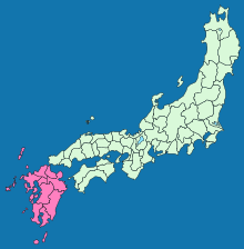
Saikaidō.
This name identified the geographic region of Kyūshū and the islands of Tsushima and Iki. It consisted of nine ancient provinces and two islands.[3] The provinces included Chikuzen, Chikugo, Buzen, Bungo, Hizen, Higo, Hyūga, Satsuma and Ōsumi.
Notes
- Deal, William E. (2005). Handbook to Life in Medieval and Early Modern Japan, p. 83.
- Nussbaum, Louis-Frédéric. (2005). "Goki-shichidō" in Japan Encyclopedia, p. 255, p. 255, at Google Books.
- Compare Nankaidō, which includes all of Shikoku, is the "southern sea circuit" and Tōkaidō is the "eastern sea circuit", made famous by the wood-block prints of Hokusai and Hiroshige.
References
- Nussbaum, Louis-Frédéric and Käthe Roth. (2005). Japan encyclopedia. Cambridge: Harvard University Press. ISBN 978-0-674-01753-5; OCLC 58053128
| Authority control |
|
|---|
This article is issued from Wikipedia. The text is licensed under Creative Commons - Attribution - Sharealike. Additional terms may apply for the media files.