Sabalgarh
Sabalgarh is a municipality of the Morena district in the Indian state of Madhya Pradesh.
Sabalgarh | |
|---|---|
city | |
 Sabalgarh Location in Madhya Pradesh, India  Sabalgarh Sabalgarh (India) | |
| Coordinates: 26.25°N 77.4°E | |
| Country | |
| State | Madhya Pradesh |
| District | Morena |
| Founded by | Sabal Singh tomar |
| Government | |
| • MLA | Baijnath Kushwah |
| Elevation | 212 m (696 ft) |
| Population (2011) | |
| • Total | 40,333 |
| Languages | |
| • Official | Hindi |
| Time zone | UTC+5:30 (IST) |
| PIN | 476229 |
| Telephone code | 07536 |
| Vehicle registration | MP06 |
| Sex ratio | 960 ♂/♀ |
In English Sabal is called "strong" and Garh is called "fort". The Sabalgarh Fort is situated on a large rock in the northeastern part of Sabalgarh, which may have contributed to the city's name. The foundation of the fort was laid by a named, Sabal Singh Gurjar. Sabal Singh Gurjar was the King of this fort. The surrounding town is also named Sabalgarh. The fortress fell into ruins and is known for stories of hauntings and ghosts. Many Hindu temples are there inside the fort campus which was destroyed by local muslims.
About 50 km from the town is Asia's largest siphon, built at the intersection of Kunu river and the Chambal right main canal. The Chambal river is 20 km away from town and is a habitat for Indian Dolphins.
Demographics
Sabalgarh has a population of 40,333, with 53% male and 47% female. Sabalgarh has an average literacy rate of 68%, lower than the national average of 74%. Male literacy was 74% while female literacy was 52%.[2] As measured in 2011, 14% of Sabalgarh's population was under six.
Scheduled Castes represent approximately 16.6% of the population, and Scheduled Tribes account for another 8.6%.
The 2011 census reported a total of 7,091 households. The area's total employed labor force was reported at 11,360. Of this number, 10,262 were categorized as regular laborers, with the remaining 1,098 categorized as irregular.
Places of interest
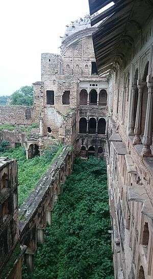
Sabalgarh Fort : The fort is noteworthy among medieval age monuments. A ‘Bandh’ was built in the Scindia period behind the fort. Sabalgarh's foundation was laid by a Gujar named Sabla. The fort was constructed on a cliff by Gopal Singh, the Raja of Karoli. Sikandar Lodhi sent an army to control this fort. The Marathas, in their campaign through northern India, retook the fort and returned control to the Raja of Karoli. In 1795 A.D., it was again taken from the Raja by Khande Rao, whose house stands there. Lord Vallejali Daulat Rao Scindia (1764–1837) lived in this fort during his regime. The fort was seized by the English in 1804. The area surrounding the fort was added to the kingdom of Scindia in 1809.[3]
Alakhiya Khoh : One of the most famous temples of Sabalgarh. It is dedicated to goddess Kaali Mata. It is an ancient temple, and every year for nine days a fair is organised on the occasion of Navratri.
Agni Missile Development Plant:[4] The chief secretary of state chief minister office has said that In August 2017 the D.R.D.O. New Delhi team has visit the town and confirmed the establishment of the plant of AGNI MISSILE in Sabalgarh and the government has already allotted 1500 hectare land for this project.
Rau Ghaat : A wonderful Tourist attraction Within Sabalagrh.[5]
Other Places :
- Rani Ka Taal
- Nawal Singh Ki Haweli
- Amar Khoh
- Devi Annapurana Maa Temple
- Atar Ghat
- Alkhiya Kho
- Rest house
- Tonga Lake
- Panchmukhi Hanuman Mandir
- Daudayal Mandir
- Majrawaale Hanumanji Mandir
- Shree Ram Mandir
- Dauji temple
- Shree Radha-Krishna Kalangi Mandir
- Thakur Baba Mandir Chambal
- Chambal River
- Beehad Of Chambal
- Rahughat Waterfall
Transport and connectivity
Railways
Sabalgarh is connected to Gwalior by a narrow gauge line. This railway is also known as "Gwalior Light Railways". The two-foot (610 mm) narrow gauge GLR is 199.8 kilometres (124.1 mi) long and runs from Gwalior to Sheopur Kalan in the Madhya Pradesh state. This line was started by Maharaja Madhav Roa II and completed in 1909. It is managed by the Central Railways department of Indian Railways. It is directly connected with Gwalior, Sheopur Kalan, Kailaras, Joura etc... In UPA government Ms. Mamata Banerjee (former railway minister) was announced Gwalior-Sheopur kalan gauge conversion with extension to Kota in 2010 railway budget but till date there is no any work on the ground. Most of the time it has seen in news paper that this project has been dropped by present NDA government. The thousands of people have angst and pain to hear this pathetic news in local or national news paper.
Roads
Sabalgarh is fairly well-connected to many cities of Madhya Pradesh by state highways. Daily buses are available for the Gwalior, Morena, Sheopur ( Shivpur ), Shivpuri, Jaipur, Kota, Agra, Mathura and Delhi etc.
Airways
Nearest Airport is located in Gwalior which is about 120 kilometer far from Sabalgarh. Daily flights are available for New Delhi and many more cities from Gwalior airport.
Distance from popular cities
References
- "Maps, Weather, and Airports for Sabalgarh, India".
- "Sabalgarh Population". ourhero.in. Archived from the original on 6 October 2014. Retrieved 9 September 2018.
- History of Sabalgarh. 5 September 2015 – via YouTube.
- "Agni Missile". DainikBhaskar (in Hindi). Bhaskar News Network. 29 August 2017.
- https://www.patrika.com/morena-news/if-you-go-to-this-tourist-spot-in-sabargadh-you-will-be-stunned-1529361/