SOLRAD 10
Solrad 10, also known Explorer 44, NRL-PL 165 and Explorer SE-C, was one of the SOLRAD series designed to provide continuous coverage of wavelength and intensity changes in solar radiation in the UV, soft and hard X-ray regions. The satellite also mapped the celestial sphere using a high-sensitivity X-ray detector.[1]
 Solrad 10. | |
| Mission type | Heliophysics |
|---|---|
| Operator | NASA |
| COSPAR ID | 1971-058A[1] |
| SATCAT no. | 5317 |
| Spacecraft properties | |
| Manufacturer | Naval Research Laboratory |
| Launch mass | 260 kilograms (570 lb) |
| Start of mission | |
| Launch date | July 8, 1971, 22:58 UTC[2] |
| Rocket | Scout B S177C |
| Launch site | Wallops LA-3A[2] |
| End of mission | |
| Decay date | 15 December 1979[3] |
| Orbital parameters | |
| Reference system | Geocentric |
| Regime | Low Earth |
| Eccentricity | 0.0006626[4] |
| Perigee altitude | 204 kilometers (127 mi)[4] |
| Apogee altitude | 213 kilometers (132 mi)[4] |
| Inclination | 51.0598°[4] |
| RAAN | 328.0487°[4] |
| Argument of perigee | 235.3867°[4] |
| Mean anomaly | 124.4027°[4] |
| Mean motion | 16.23884333[4] |
| Epoch | 13 December 1979[4] |
| Revolution no. | 46942[4] |
Explorers | |
Launch
Solrad 10 was launched on 8 July 1971 from Wallops Flight Facility, Virginia, with a Scout rocket. When it was launched, it had an orbit with 630 kilometres (390 mi) of apogee, 436 kilometres (271 mi) of perigee, 51.1 degrees of orbital inclination and 1 hour and 35 minutes of orbital period.[1][5]
Spacecraft
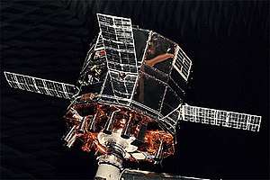
Solrad 10 was a 12-sided cylinder that measured 76 centimetres (30 in) in diameter and 58 centimetres (23 in) in height. Four symmetrically placed 17.8 by 53.3 centimetres (7.0 in × 21.0 in) solar cell panels, hinged at the central section of the structure, served as the elements of a turnstile antenna system. 18 solar sensors were mounted pointing parallel to the spin axis of the satellite, which pointed directly at the solar disk. The plane of rotation shifted about 1°/day so that a stellar detector mounted to point radially outward from the axis scanned the celestial sphere. Data from all detectors were stored in a 54 kbs core memory and telemetered on command to the NRL Satellite Operations Center at Blossom Point, Maryland. Data were also transmitted in real time at 137.710 MHz.[1]
Solrad 10 decayed and returned to the Earth on December 15, 1979.[3]
See also
- Solrad 9
References
- "Solrad 10". NSSDCA. NASA Goddard Space Flight Center. Retrieved 19 June 2018.

- McDowell, Jonathan. "Launch Log". Jonathan's Space Page. Retrieved 19 June 2018.
- "EXPLORER 44 (SOLRAD-10)". n2yo.com. Retrieved 19 June 2018.
- Peat, Chris. "Solrad 10 - Orbit". Heavens-Above GmbH. Retrieved 19 June 2018.
- Wade, Mark (2017). "Solrad". Encyclopedia Astronautica. Retrieved 19 June 2018.
External links
- SOLRAD/GRAB. Naval Research Laboratory