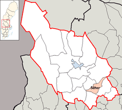
Säter Municipality
Säter Municipality (Säters kommun) is one of the 290 municipalities of Sweden in Dalarna County in central Sweden. Its seat is located in the town of Säter.
Säter Municipality Säters kommun | |
|---|---|
 | |
 Coat of arms | |
 | |
| Country | Sweden |
| County | Dalarna County |
| Seat | Säter |
| Area | |
| • Total | 624.51 km2 (241.12 sq mi) |
| • Land | 570.33 km2 (220.21 sq mi) |
| • Water | 54.18 km2 (20.92 sq mi) |
| Area as of 1 January 2014. | |
| Population (31 December 2019)[2] | |
| • Total | 11,093 |
| • Density | 18/km2 (46/sq mi) |
| Time zone | UTC+1 (CET) |
| • Summer (DST) | UTC+2 (CEST) |
| ISO 3166 code | SE |
| Province | Dalarna |
| Municipal code | 2082 |
| Website | www.sater.se |
| Density is calculated using land area only. | |
The present municipality was created in 1971 with the amalgamation of the former City of Säter and two neighbouring municipalities.
Geography
Säter is known for the Säter Valley. It is about 5 kilometers long and has a dense vegetation and steeps. On its bottom the Ljuster stream flows. The valley is popular for walking.
Sights
The Old Church of Stora Skedvi is one of Dalarna's oldest, with its oldest parts from the 13th century.
There are several remains from the province's mining history, such as the Östra Silvberg's Mining Area with a silver mining history traced to the 1480s with an adjacent cemetery and chapel. It was closed in the 19th century and the mine itself is today a water filled hole.
Bispbergs gruva was used for mining iron for over 600 years, until it was closed in 1967.
References
- "Statistiska centralbyrån, Kommunarealer den 1 januari 2014" (in Swedish). Statistics Sweden. 2014-01-01. Archived from the original (Microsoft Excel) on 2016-09-27. Retrieved 2014-04-18.
- "Folkmängd i riket, län och kommuner 31 december 2019" (in Swedish). Statistics Sweden. February 20, 2020. Retrieved February 20, 2020.
- (in Swedish) article Säter from Nordisk Familjebok (1919).
External links
- Säter - Official site
Municipalities and seats of Dalarna County | ||
|---|---|---|
| Municipalities | ||
| Municipal seats | ||
| Authority control |
|
|---|