Sächsische Schweiz-Osterzgebirge
Saxon Switzerland-Eastern Ore Mountains (German: Sächsische Schweiz-Osterzgebirge; Czech: Saské Švýcarsko a východní Krušné hory; Upper Sorbian: Wokrjes Sakska Šwica-Wuchodne Rudne hory) is a district (Kreis) in the Free State of Saxony, Germany. It is named after the mountain ranges Saxon Switzerland and Eastern Ore Mountains.
Sächsische Schweiz-Osterzgebirge | |
|---|---|
 Coat of arms | |

| |
| Country | Germany |
| State | Saxony |
| Capital | Pirna |
| Area | |
| • Total | 1,654 km2 (639 sq mi) |
| Population (31 December 2018)[1] | |
| • Total | 245,611 |
| • Density | 150/km2 (380/sq mi) |
| Time zone | UTC+01:00 (CET) |
| • Summer (DST) | UTC+02:00 (CEST) |
| Vehicle registration | PIR, DW, FTL, SEB |
| Website | www |
History
The district was established by merging the former districts of Sächsische Schweiz and Weißeritzkreis as part of the district reform of August 2008.
Geography
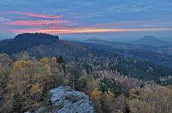
The district is located between Dresden and the Czech Republic. In the southwestern part of the district the easternmost part of the Ore Mountains (″Erzgebirge") is found, the southeastern part of the district is named Saxon Switzerland, which is part of the Elbe Sandstone Mountains. The main river of the district is the Elbe. The district borders (from the west and clockwise) the districts of Mittelsachsen and Meißen, the urban district Dresden, the district of Bautzen, and the Czech Republic.
Towns and municipalities
| Towns | Municipalities | ||
|---|---|---|---|
References
- "Bevölkerung des Freistaates Sachsen jeweils am Monatsende ausgewählter Berichtsmonate nach Gemeinden" (PDF). Statistisches Landesamt des Freistaates Sachsen (in German). July 2019.
External links
![]()
- Official website (German)
| Urban districts | |
|---|---|
| Rural districts | |
| Former urban districts | |
| Former rural districts | |
| Authority control |
|
|---|