São Francisco do Sul
São Francisco do Sul is a municipality in the Brazilian state of Santa Catarina. It covers an area of 540 km² (208 miles2) and had an estimated population of 42,569 in 2011.[1]
São Francisco do Sul | |
|---|---|
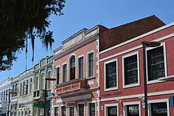 Historic center of São Francisco do Sul | |
 Flag  Coat of arms | |
 Location in Santa Catarina state | |
 São Francisco do Sul Location in Brazil | |
| Coordinates: 26°14′34″S 48°38′16″W | |
| Country | Brazil |
| Region | South |
| State | Santa Catarina |
| Mesoregion | Norte Catarinense |
| Microregion | Joinville |
| Founded | 1658 |
| Area | |
| • Total | 540 km2 (210 sq mi) |
| Population (2011) | |
| • Total | 42,569 |
| • Density | 79/km2 (200/sq mi) |
| Time zone | UTC-03:00 (BRT) |
| • Summer (DST) | UTC-02:00 (BRST) |
| Website | www |
Location
It was founded as a village by the Portuguese in 1658. Despite the date of its foundation, there's a previous record that a famous navigator left Honfleur, Normandy in France by the year of 1503 and arrived at São Francisco do Sul, at the Bay of Babitonga, Jean Binot Paulmier De Gonneville is also recognised by many historians as one of the first, if not the first, Europeans to arrive. It is situated on the northern end of the Island of São Francisco at the entrance to the Babitonga Bay.
São Francisco do Sul is an important part of the Brazilian infrastructure. It provides large bulk shipping facilities and is served by the major container shipping lines connecting with the South American east and west coasts, Africa, Asia, North and Central America, the Caribbean and Europe.[2]
During the past decade, São Francisco do Sul has become a popular tourism destination for South American and international guests.[3] The municipality contains the 6,667 hectares (16,470 acres) Acaraí State Park, created in 2005.[4]
International relations
References
- http://www.saofranciscodosul.ciasc.gov.br/en/a-cidade/
- http://www.terminalsc.com.br/en/institucional/terminal.php
- http://www.msccruisesusa.com/us_en/Cruise-Destinations/South-America/Brazil/Sao-Francisco-Do-Sul.aspx
- Parque Estadual Acaraí (in Portuguese), FATMA, retrieved 2016-11-29
- "National Commission for Decentralised cooperation". Délégation pour l’Action Extérieure des Collectivités Territoriales (Ministère des Affaires étrangères) (in French). Archived from the original on 2013-11-27. Retrieved 2013-12-26.
External links
| Wikimedia Commons has media related to São Francisco do Sul. |
- Tour Virtual of São Francisco do Sul - Brazilian Site
- Official site of the port of Sao Francisco do Sul
| |
| Canoinhas | |
| Joinville | |
| São Bento do Sul | |