Rust, Baden-Württemberg
Rust is a town in the district of Ortenau in Baden-Württemberg in Germany. It is also the home of the famous theme park Europa-Park. The Renaissance era Balthasar Castle is now part of the theme park. The protected floodplain forest Taubergießen is adjacent to Rust.
Rust | |
|---|---|
 Coat of arms | |
Location of Rust within Ortenaukreis district 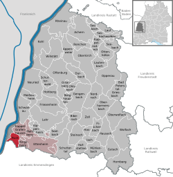 | |
 Rust 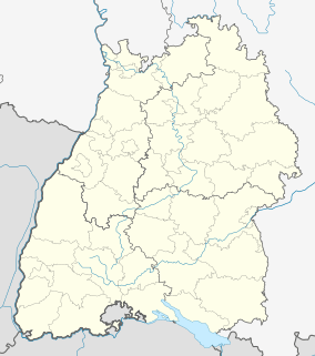 Rust | |
| Coordinates: 48°16′06″N 07°43′40″E | |
| Country | Germany |
| State | Baden-Württemberg |
| Admin. region | Freiburg |
| District | Ortenaukreis |
| Government | |
| • Mayor | Kai-Achim Klare (SPD) |
| Area | |
| • Total | 13.27 km2 (5.12 sq mi) |
| Elevation | 169 m (554 ft) |
| Population (2018-12-31)[1] | |
| • Total | 4,285 |
| • Density | 320/km2 (840/sq mi) |
| Time zone | CET/CEST (UTC+1/+2) |
| Postal codes | 77977 |
| Dialling codes | 07822 |
| Vehicle registration | OG |
| Website | www.rust.de |
Geography
Rust is located between the Black Forest and the Vosges where the Elz (Baden) River merges with the Upper Rhine River Plains from the southeast. The Elz enters the city from the south and runs in a northwesterly direction first through the village and borders the Europa-Park, Germany's largest amusement park.
Neighbouring communities
The following cities and towns share a border with Lahr. They are listed clockwise starting from the north: Kappel-Grafenhausen, Ringsheim, Rheinhausen.
Climate
The Climate in this area has mild differences between highs and lows, and there is adequate rainfall year-round. The Köppen Climate Classification subtype for this climate is "Cfb" (Marine West Coast Climate/Oceanic climate). However, it is close to being "humid subtropical climate" due to the mean temperatures in July and August just under 22 °C. [2]. [3].
| Climate data for Rust (CFB Lahr) 2015-2020 Extremes; High, Low, Mean Temperatures with precipitation + Sunny days | |||||||||||||
|---|---|---|---|---|---|---|---|---|---|---|---|---|---|
| Month | Jan | Feb | Mar | Apr | May | Jun | Jul | Aug | Sep | Oct | Nov | Dec | Year |
| Record high °C (°F) | 15.7 (60.3) |
20.5 (68.9) |
24.4 (75.9) |
29.8 (85.6) |
32.8 (91.0) |
37.0 (98.6) |
38.4 (101.1) |
39.5 (103.1) |
32.2 (90.0) |
27.7 (81.9) |
23.0 (73.4) |
16.9 (62.4) |
39.5 (103.1) |
| Average high °C (°F) | 6.1 (43.0) |
7.8 (46.0) |
12.5 (54.5) |
17.0 (62.6) |
20.7 (69.3) |
25.2 (77.4) |
28.0 (82.4) |
27.2 (81.0) |
22.5 (72.5) |
16.3 (61.3) |
10.5 (50.9) |
7.6 (45.7) |
16.8 (62.2) |
| Daily mean °C (°F) | 3.1 (37.6) |
3.7 (38.7) |
7.3 (45.1) |
11.0 (51.8) |
15.1 (59.2) |
19.5 (67.1) |
21.7 (71.1) |
20.5 (68.9) |
16.0 (60.8) |
11.1 (52.0) |
6.8 (44.2) |
4.5 (40.1) |
11.65 (52.97) |
| Average low °C (°F) | −0.3 (31.5) |
−0.4 (31.3) |
2 (36) |
4.7 (40.5) |
9.3 (48.7) |
13.5 (56.3) |
15.0 (59.0) |
14.1 (57.4) |
10.0 (50.0) |
6.3 (43.3) |
2.8 (37.0) |
1.1 (34.0) |
6.5 (43.7) |
| Record low °C (°F) | −11.8 (10.8) |
−12.6 (9.3) |
−4.9 (23.2) |
−2.8 (27.0) |
1.1 (34.0) |
6.1 (43.0) |
6.4 (43.5) |
6.5 (43.7) |
1.2 (34.2) |
−2.1 (28.2) |
−7.2 (19.0) |
−6.7 (19.9) |
−12.6 (9.3) |
| Average precipitation mm (inches) | 60 (2.4) |
40 (1.6) |
42 (1.7) |
66 (2.6) |
108 (4.3) |
69 (2.7) |
58 (2.3) |
49 (1.9) |
45 (1.8) |
44 (1.7) |
49 (1.9) |
46 (1.8) |
676 (26.6) |
| Average rainy days (≥ 0.2 mm) | 18 | 13 | 13 | 14 | 15 | 13 | 12 | 11 | 10 | 11 | 14 | 16 | 160 |
| Average snowy days (≥ 0.2 cm) | 4 | 3 | 2 | 1 | 0 | 0 | 0 | 0 | 0 | 0 | 1 | 4 | 15 |
| Average relative humidity (%) | 87 | 84 | 77 | 72 | 73 | 73 | 73 | 76 | 80 | 86 | 85 | 87 | 79 |
| Mean monthly sunshine hours | 53 | 95 | 152 | 193 | 216 | 244 | 274 | 244 | 196 | 109 | 63 | 56 | 1,895 |
| Source: Wetterdienst[4] | |||||||||||||
External links

References
- "Bevölkerung nach Nationalität und Geschlecht am 31. Dezember 2018". Statistisches Landesamt Baden-Württemberg (in German). July 2019.
- Climate Summary for Lahr
- "Lahr". Principal Station Data. Wetterdienst. Archived from the original on 2 February 2020. Retrieved 2 February 2020.

| Authority control |
|
|---|