Rushen
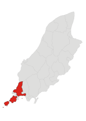
Rushen (/ˈrʊʃən/ RUUSH-ən; Manx: Rosien), formally Kirk Christ Rushen, is one of the seventeen historic parishes of the Isle of Man.
Rushen
| |
|---|---|
 Parish of Rushen, Isle of Man | |
| Population | 1,537 [1] |
| OS grid reference | SC203689 |
| Sheading | Rushen |
| Crown dependency | Isle of Man |
| Post town | ISLE OF MAN |
| Postcode district | IM5 |
| House of Keys | Rushen |
It is located in the south of the island (part of the traditional South Side division) in the sheading of the same name.
Administratively, part of the historic parish of Rushen, and the majority of the population, is now covered by the village districts of Port Erin and Port St Mary. As a result, there is an exclave of the parish district which includes the Calf of Man.
Other settlements in the parish include Cregneash.
Local government
For the purposes of local government, the majority of the area of the historic parish forms a single parish district, with Commissioners.[2]
Since the 1880s, two areas of the historic parish of Rushen have been the two separate village districts of Port Erin and Port St Mary, each with its own village commissioners.[3][4]
The Captain of the Parish (since 1998) is Stanley Ditchfield Clucas.[5]
Politics
Rushen parish is split between two House of Keys constituencies: Rushen, covering the majority of the parish including Port Erin and Port St Mary, and the Arbory, Castletown & Malew constituency, which covers the eastern part of the historic parish. Each constituency elects two Members to the House of Keys. Before 2016 the whole parish was in the Rushen constituency.
Geography
Rushen parish includes the south-western extremity of the island, together with the Calf of Man along with its rocky outcrops Kitterland and Chicken Rock, and contains an area of about 10 square miles (26 km2). It stretches round the coast from Strandhall (on the coast about halfway between Castletown and Port St Mary) to the precipices west of Cronk ny Irrey Laa (Hill of the Day Watch, also spelled Arrey), known as the Stacks, or the Slogh, a distance of 16 miles (26 km). The principal headlands are Kallow Point, Black Head, Spanish Head (350 feet (110 m)), and Bradda Head (766 feet (233 m)); and the chief inlets are Port St Mary Bay, Perwick Bay, Bay Stacka, Port Erin Bay, and Fleshwick Bay.
The west of the parish is hilly, stretching southwards from Cronk ny Irrey Laa (437 metres (1,434 ft), the highest point in the parish) along the western coast to Lhiattee ny Beinnee, Bradda Hill, Mull Hill, and the Sound, across which the ridge is continued on the Calf.
Port St Mary and Port Erin are the only significant settlements in the area, although they have now expanded to form a single continuous settlement. Cregneash is a small village and folk museum near Mull Hill.[6]
Demographics
The Isle of Man census of 2016 returned a parish population of 1,537, a decrease of 6% from the figure of 1,629 in 2011.[1] At the time of the 2011 census, 2.64% of the parish could speak Manx Gaelic.
References
- "2016 Isle of Man Census Report" (PDF). Gov.im. Retrieved 19 July 2019.
- "Rushen Parish Commissioners". Retrieved 10 April 2019.
- "Port Erin Commissioners". Retrieved 10 April 2019.
- "Port St Mary Commissioners". Retrieved 10 April 2019.
- "Captains of the Parishes". Culture Vannin. Retrieved 10 April 2019.
- "Rushen Parish". isleofman.com. Retrieved 14 October 2008.
External links
- Manxnotebook - Rushen with full description of the parish
- Isle of Man Building Control Districts showing parish boundaries
- Great.Outdoors.com/ManxGlens Glenology - Manx Glens An ongoing study of Manx glens, their locations and meanings.
- Rushen Parish Commissioners
- GeoHive Census Information