Rumley Township, Harrison County, Ohio
Rumley Township is one of the fifteen townships of Harrison County, Ohio, United States. As of the 2010 census the population was 1,471,[3] of whom 779 lived in the unincorporated portion of the township.
Rumley Township, Harrison County, Ohio | |
|---|---|
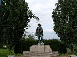 George Armstrong Custer monument in New Rumley | |
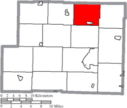 Location of Rumley Township in Harrison County | |
| Coordinates: 40°22′46″N 81°0′37″W | |
| Country | United States |
| State | Ohio |
| County | Harrison |
| Area | |
| • Total | 23.31 sq mi (60.38 km2) |
| • Land | 23.30 sq mi (60.34 km2) |
| • Water | 0.02 sq mi (0.05 km2) |
| Elevation | 1,207 ft (368 m) |
| Population (2010) | |
| • Total | 1,471 |
| • Density | 63/sq mi (24.4/km2) |
| Time zone | UTC-5 (Eastern (EST)) |
| • Summer (DST) | UTC-4 (EDT) |
| FIPS code | 39-68994[2] |
| GNIS feature ID | 1086282[1] |
Geography
Located in the northern part of the county, it borders the following townships:
- Loudon Township, Carroll County - north
- North Township - west
- German Township - east
- Archer Township - south
- Perry Township, Carroll County - northwest
The village of Jewett is located in southern Rumley Township, and the unincorporated community of New Rumley lies in the township's center.
Name and history
It is the only Rumley Township statewide.[4]
Government
The township is governed by a three-member board of trustees, who are elected in November of odd-numbered years to a four-year term beginning on the following January 1. Two are elected in the year after the presidential election and one is elected in the year before it. There is also an elected township fiscal officer,[5] who serves a four-year term beginning on April 1 of the year after the election, which is held in November of the year before the presidential election. Vacancies in the fiscal officership or on the board of trustees are filled by the remaining trustees.
References
- "US Board on Geographic Names". United States Geological Survey. 2007-10-25. Retrieved 2008-01-31.
- "U.S. Census website". United States Census Bureau. Retrieved 2008-01-31.
- "Geographic Identifiers: 2010 Census Summary File 1 (G001): Rumley township, Harrison County, Ohio". American Factfinder. U.S. Census Bureau. Archived from the original on February 13, 2020. Retrieved December 29, 2017.
- "Detailed map of Ohio" (PDF). United States Census Bureau. 2000. Retrieved 2007-02-16.
- §503.24, §505.01, and §507.01 of the Ohio Revised Code. Accessed 4/30/2009.
External links
Municipalities and communities of Harrison County, Ohio, United States | ||
|---|---|---|
| Villages |  Map of Ohio highlighting Harrison County | |
| Townships | ||
| CDP | ||
| Unincorporated communities | ||
| Ghost towns | ||
| Footnotes | ‡This populated place also has portions in an adjacent county or counties | |