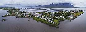
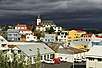
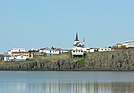
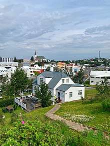
Borgarnes
Borgarnes (Icelandic pronunciation: [ˈpɔrkarˌnɛs]) is a town located on a peninsula at the shore of Borgarfjörður in Iceland and is the largest town in the Borgarbyggð municipality with a population of about 3750 residents. It is a main junction in Iceland and the gateway to the Snaefellsnes National Park. Iceland's capital Reykjavik is 69 kilometers from the center of Borgarnes. The second largest bridge in Iceland, the Borgarfjarðarbrú, connects traffic to and from Reykjavik.
Borgarnes | |
|---|---|
Town | |
Borgarnes | |
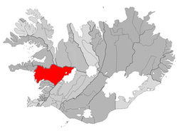 Location of the Municipality of Borgarbyggð | |
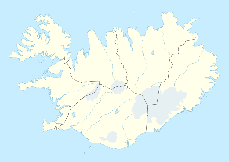 Borgarnes Location in Iceland | |
| Coordinates: 64°32′N 21°55′W | |
| Country | Iceland |
| Constituency | Northwest Constituency |
| Region | Western Region |
| Municipality | Borgarbyggð |
| Population (2015) | |
| • Total | 1,875 |
| Time zone | UTC+0 (GMT) |


.jpeg)
.jpeg)
Local area
There are four national forests in the region (approximately 40 km from the town center) which are overseen by the Icelandic Forest Service.[1] The forest in Borgarfjardur are mix of Birch woods and native conifers. These forests are Vatnshorn, Norðtunga, Selskógar, Stalpastaðir and Jafnaskarð. Borgarnes has the oldest and tallest of the birch trees in Iceland.[2]
History
Borgarnes was founded in the late nineteenth-century, in a region that served as the setting of Egil's Saga.[3] The town draws its name from Borg á Mýrum, the farm of Egill Skallagrimsson, the saga's poet-hero protagonist. A museum in Borgarnes, the Settlement Center, is devoted to the region's ties to Egill Skallagrimsson.[4]
Arts & Culture
The Safnahús Borgarfjarðar is a civilization museum that displays cultural artifacts and historical photos.[5] Safnahús Borgarfjarðar was one of Iceland's first collections to receive the formal recognition of the Saga Council in (2013).[6]
Borgarnes is also one of the filming locations in the Hollywood film The Secret Life of Walter Mitty. The Geirabakari Kaffihus, which is featured in the film, was transformed into Papa John's during the filming.[7] Borgarnes is the birthplace of Icelandic composer Anna Thorvaldsdottir.

References
- "Iceland forest service | Skógræktin". www.skogur.is. Archived from the original on 2015-07-30. Retrieved 2018-03-18.
- "Vesturland | Skógræktin". www.skogur.is (in Icelandic). Archived from the original on 2018-03-19. Retrieved 2018-03-18.
- "Saga Spots: Searching for Egill in Borgarnes". The Reykjavik Grapevine. 2018-08-27. Retrieved 2019-08-03.
- Iceland, West. "The Settlement Center". Visit West Iceland. Retrieved 2019-08-03.
- grapevine.is (2016-03-24). "Take A Moment: There's More To Borgarnes Than Bónus And N1 - The Reykjavik Grapevine". The Reykjavik Grapevine. Retrieved 2018-03-18.
- "Safnahús Borgarfjarðar – Borgarnes Museum". safnahus.is. Retrieved 2018-03-18.
- "Ben Stiller breytir Geirabakarí í Borgarnesi í pizzastaðinn Papa Johns". Pressan.is (in Icelandic). Retrieved 2018-03-18.
- "Aslaug Helgadottir | PhD | The Agricultural University of Iceland, Borgarnes | LBHI | Department of Land and Animal Resources | ResearchGate". ResearchGate. Retrieved 2018-03-18.
- Review, Iceland (2009-02-11). "Borgarnes Settlement Center Museum Awarded". Iceland Review. Retrieved 2018-03-18.
| Climate data for Hvanneyri, 6.6 km (4.1 mi) from Borgarnes (1964-1993) | |||||||||||||
|---|---|---|---|---|---|---|---|---|---|---|---|---|---|
| Month | Jan | Feb | Mar | Apr | May | Jun | Jul | Aug | Sep | Oct | Nov | Dec | Year |
| Record high °C (°F) | 11.5 (52.7) |
10.8 (51.4) |
15.8 (60.4) |
15.9 (60.6) |
20.8 (69.4) |
19.5 (67.1) |
26.1 (79.0) |
22.0 (71.6) |
18.6 (65.5) |
15.0 (59.0) |
13.4 (56.1) |
11.8 (53.2) |
26.1 (79.0) |
| Average high °C (°F) | 1.1 (34.0) |
2.1 (35.8) |
2.4 (36.3) |
5.1 (41.2) |
9.2 (48.6) |
12.1 (53.8) |
13.6 (56.5) |
13.1 (55.6) |
9.7 (49.5) |
6.0 (42.8) |
2.8 (37.0) |
1.5 (34.7) |
6.6 (43.8) |
| Daily mean °C (°F) | −2.3 (27.9) |
−1.1 (30.0) |
−0.8 (30.6) |
1.9 (35.4) |
5.6 (42.1) |
8.6 (47.5) |
10.3 (50.5) |
9.7 (49.5) |
6.4 (43.5) |
3.0 (37.4) |
−0.2 (31.6) |
−1.9 (28.6) |
3.3 (37.9) |
| Average low °C (°F) | −6.1 (21.0) |
−4.4 (24.1) |
−4.0 (24.8) |
−1.3 (29.7) |
2.0 (35.6) |
5.3 (41.5) |
7.1 (44.8) |
6.4 (43.5) |
3.1 (37.6) |
−0.1 (31.8) |
−3.5 (25.7) |
−5.5 (22.1) |
−0.1 (31.9) |
| Record low °C (°F) | −24.2 (−11.6) |
−22.0 (−7.6) |
−20.8 (−5.4) |
−23.1 (−9.6) |
−10.1 (13.8) |
−3.7 (25.3) |
0.0 (32.0) |
−4.7 (23.5) |
−7.3 (18.9) |
−15.6 (3.9) |
−18.2 (−0.8) |
−22.0 (−7.6) |
−24.2 (−11.6) |
| Average precipitation mm (inches) | 90.9 (3.58) |
98.8 (3.89) |
85.6 (3.37) |
67.4 (2.65) |
48.6 (1.91) |
53.1 (2.09) |
51.0 (2.01) |
73.5 (2.89) |
69.1 (2.72) |
100.9 (3.97) |
97.2 (3.83) |
100.0 (3.94) |
936.1 (36.85) |
| Source: Icelandic Met Office[1] | |||||||||||||

| Authority control |
|
|---|
- "Monthly Temperature and Precipitation Averages for Hvanneyri". Icelandic Meteorological Office. Retrieved 4 June 2016.