Roslyn, New York
Roslyn (/ˈrɒzlɪn/ ROZ-lin) is a village in Nassau County, New York, on the North Shore of Long Island. As of the 2010 Census, the village population was 2,770. Initially Roslyn was settled in the year 1633.[6] Roslyn was once called Hempstead Harbor, but its name changed to Roslyn on September 7, 1844 due to postal confusion regarding all the other "Hempsteads" scattered about Long Island.[7]
Roslyn,New York | |
|---|---|
Village | |
| Village of Roslyn | |
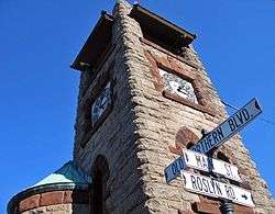 Clock tower at Main Street and Old Northern Boulevard, Roslyn's best-known landmark | |
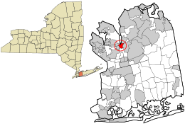 Location in Nassau County and the state of New York. | |
 Location within the state of New York | |
| Coordinates: 40°48′0″N 73°39′02″W[1] | |
| Country | United States |
| State | New York |
| Town | North Hempstead |
| Settled | 1643[2] |
| Incorporated | 1932[2] |
| Government | |
| • Mayor | John Durkin |
| Area | |
| • Total | 0.6 sq mi (2 km2) |
| • Land | 0.6 sq mi (2 km2) |
| Elevation | 91 ft (300 m) |
| Population | |
| • Total | 2,770 |
| • Estimate (2018)[5] | 2,882 |
| • Density | 4,600/sq mi (1,800/km2) |
| Time zone | UTC-5 (Eastern (EST)) |
| • Summer (DST) | UTC-4 (EDT) |
| ZIP code(s) | 11576 |
| Area code(s) | 516 |
| FIPS code | 36-63770 |
| GNIS feature ID | 0962929 |
| Website | www |

.jpg)
The Village of Roslyn is at the eastern edge of the Town of North Hempstead.
Geography
According to the United States Census Bureau, the village has a total area of 0.6 square miles (1.6 km2), of which, 0.6 square miles (1.6 km2) of it is land and 1.56% is water.
Demographics
| Historical population | |||
|---|---|---|---|
| Census | Pop. | %± | |
| 1940 | 972 | — | |
| 1950 | 1,612 | 65.8% | |
| 1960 | 2,681 | 66.3% | |
| 1970 | 2,607 | −2.8% | |
| 1980 | 2,134 | −18.1% | |
| 1990 | 1,965 | −7.9% | |
| 2000 | 2,570 | 30.8% | |
| 2010 | 2,770 | 7.8% | |
| Est. 2018 | 2,882 | [5] | 4.0% |
| U.S. Decennial Census[8] | |||
2010 Census
As of the 2010 census [9] the population was 86% White (76% Non-Hispanic White), 2.2% Black or African American, 0.2% Native American, 8.85% Asian, 2.6% from other races, and 2.2% from two or more races. Hispanic or Latino of any race were 11.2% of the population.
2000 Census
As of the census [4] of 2000, there were 2,570 people, 1,060 households, and 603 families residing in the village. The population density was 4,082.2 people per square mile (1,575.1/km²). There were 1,124 housing units at an average density of 1,785.4 per square mile (688.9/km²). The racial makeup of the village was 86.81% White, 2.33% African American, 0.08% Native American, 6.15% Asian, 2.02% from other races, and 2.61% from two or more races. Hispanic or Latino of any race were 6.34% of the population.
There were 1,060 households out of which 25.8% had children under the age of 18 living with them, 47.3% were married couples living together, 7.1% had a female householder with no husband present, and 43.1% were non-families. 37.7% of all households were made up of individuals and 9.5% had someone living alone who was 65 years of age or older. The average household size was 2.17 and the average family size was 2.89.
In the village, the population was spread out with 18.2% under the age of 18, 3.6% from 18 to 24, 30.2% from 25 to 44, 25.3% from 45 to 64, and 22.7% who were 65 years of age or older. The median age was 44 years. For every 100 females, there were 83.8 males. For every 100 females age 18 and over, there were 78.4 males.
The median income for a household in the village was $72,404, and the median income for a family was $101,622. Males had a median income of $65,156 versus $45,221 for females. The per capita income for the village was $47,166. About 1.3% of families and 4.1% of the population were below the poverty line, including 2.9% of those under age 18 and 2.7% of those age 65 or over.
Politics
Politically, Roslyn leans moderately Democratic. In 2008, Democrat Barack Obama defeated Republican John McCain 59%-40%.
Greater Roslyn area
In addition to the Village of Roslyn, the following villages and unincorporated areas are considered part of the Greater Roslyn area:
- East Hills
- Flower Hill
- Greenvale
- Roslyn Estates
- Roslyn Harbor
- Roslyn Heights
- Searingtown
Education
The Village of Roslyn is served by the Roslyn Union Free School District, which consists of five schools: Heights School, Harbor Hill School, East Hills School, Roslyn Middle School, and Roslyn High School.[10] Roslyn High School is ranked 42nd in the state and 342nd in the nation[11] The Roslyn school mascot is a Bulldog.
The Heights School serves as pre-kindergarten and kindergarten for the entire district, and as first grade for half the students in the Roslyn area (students that will attend East Hills School for elementary school).
The two elementary schools each serve half of the Roslyn school district. Harbor Hill School provides education for students in grades one through five. The East Hills School serves students in grades two through five.
Roslyn Middle School has grades six through eight. Roslyn High School, built on land donated by the Mackay family, serves students in grades nine through twelve.
Notable people
- Gary Ackerman, Democratic Congressman for the 5th District of New York State
- Eric Asimov, former dining reporter for The New York Times
- Deborah Asnis, infectious disease specialist, reported the first human cases of West Nile virus in the United States in 1999[12]
- Frances Hodgson Burnett, author of The Secret Garden, A Little Princess and Little Lord Fauntleroy
- Nathan Banks, entomologist and arachnologist.
- William Casey, former director of the CIA
- Michael Crichton, author of Jurassic Park and creator of ER
- William Cullen Bryant, poet, journalist and editor
- Allison Danzig, sportswriter for The New York Times and author
- Hal David, Grammy-winning, lyrics-writing partner of composer Burt Bacharach
- Judy Steinberg Dean, physician, First Lady of Vermont (1991–2003) and wife of former Gov. Howard Dean, Roslyn High School graduate
- Katarzyna Dolinska, contestant on America's Next Top Model
- Carolyn Gusoff, journalist
- Jeffrey Guterman, author of ‘’Mastering the Art of Solution-Focused Counseling’’, Roslyn High School graduate
- Roman Hamrlík, retired National Hockey League defenseman
- Ken Hechler, West Virginia, Democratic politician
- Paul Housberg, artist
- Stan Isaacs, Newsday sports columnist
- Jesse Itzler, entrepreneur, author, co-owner of the Atlanta Hawks
- Henry Jackson, financier
- Brian Koppelman, filmmaker, essayist, podcaster, TV series creator, former music business executive and record producer
- Bobby Kotick, CEO, president, and a director of Activision Blizzard
- Edward Lampert, Chairman of Sears Holding Company
- Kenneth Langone, Home Depot Founder And NYU Langone Health namesake
- Wendy Liebman, comedian
- Clarence Mackay, financier
- Bernard Madoff, former NASDAQ chairman and swindler [13]
- Janet Maslin, former New York Times critic
- Shep Messing (born 1949), Olympic soccer goalkeeper and current broadcaster
- Chris Miller, co-writer of screenplay for Animal House
- Gabriela Mistral, Chilean poet and Nobel laureate
- Christopher Morley, foremost American children's author who died at his home, "Green Escape", in Roslyn Estates in 1957
- Frank C. Moore, artist and AIDS activist
- Eugene H. Nickerson, Democratic Nassau County Executive, Long Island, N.Y., 1962–1970, and federal district court judge whose trials included the Abner Louima police brutality case
- Lilly Pulitzer, socialite and fashion designer
- J.P. Rosenbaum, winner of Season 7 of ABC's The Bachelorette
- Michael Sampson, children's author
- José A. Santos, jockey and winner of the 2003 Kentucky Derby
- Adam Schefter, NFL reporter for ESPN who lives in Roslyn Harbor
- Jen Selter, fitness model and internet celebrity
- Gregory B. Starr, Assistant Secretary for Diplomatic Security (2013 – 2017)
- Darin Strauss, author
- Darryl Strawberry, former Major League Baseball outfielder
- Stephen Taber, Congressman from New York from 1865–1869
- Van Toffler, former MTV executive
- Whitney Tower, former president of National Museum of Racing and Hall of Fame
- Fred Wilpon, owner of the New York Mets
- Jeff Wilpon, COO, the New York Mets, son of Fred Wilpon
See also
- Roslyn (LIRR station)
References
- "US Gazetteer files: 2010, 2000, and 1990". United States Census Bureau. 2011-02-12. Retrieved 2011-04-23.
- Sloam, Myrna (2006). "Timeline of Roslyn History". Nassau County Library. Archived from the original on 2008-07-04. Retrieved 2008-07-02.
- "US Board on Geographic Names". United States Geological Survey. 2007-10-25. Retrieved 2008-01-31.
- "U.S. Census website". United States Census Bureau. Retrieved 2008-01-31.
- "Population and Housing Unit Estimates". Retrieved December 3, 2019.
- NY, Village of Roslyn. "Village of Roslyn, NY - About Roslyn". www.historicroslyn.org. Retrieved 2016-04-17.
- About Roslyn Archived 2007-09-27 at the Wayback Machine
- "Census of Population and Housing". Census.gov. Retrieved June 4, 2015.
- "U.S. Census website".
- Roslyn Public Schools
- "Roslyn High School in ROSLYN HEIGHTS, NY | Best High Schools | US News". www.usnews.com. Retrieved 2016-04-17.
- Colker, David (2015-09-21). "Deborah Asnis dies at 59; helped detect West Nile virus in U.S." Los Angeles Times. Retrieved 2015-10-10.
- "Wall Street legend Bernard Madoff arrested over $50 billion Ponzi scheme". The Times. London. 2008-12-12. Retrieved 2010-05-22.
| Wikimedia Commons has media related to Roslyn, New York. |
External links
Places adjacent to Roslyn, New York | |
|---|---|
| Authority control |
|
|---|