Rosh Pinah
Rosh Pinah is a mining town[2] located in southern Namibia, close to the border with South Africa. It is situated 360 kilometres (220 mi) south of Keetmanshoop in Namibia's ǁKaras Region. West of the town lies Diamond Area 1, the main diamond mining area of Namibia. Rosh Pinah belongs to the Oranjemund electoral constituency. The town is connected via road to Aus[3] and Oranjemund.
Rosh Pinah | |
|---|---|
Settlement | |
 Bird's eye view of Rosh Pinah (October 2016) | |
 Rosh Pinah Location in Namibia | |
| Coordinates: 27°57′54″S 16°45′36″E | |
| Country | |
| Region | ǁKaras Region |
| Constituency | Oranjemund Constituency |
| Population (2011)[1] | |
| • Total | 2,835 |
| Time zone | UTC+2 (South African Standard Time) |
Copper was discovered here in the 1920s, and in 1963 German-born Jew Mose Kohan discovered zinc in the nearby Hunz Mountains in 1963. He also coined the name "Rosh Pinah" which is a Hebrew term for "cornerstone".[4] More significant deposits of zinc were found in 1968.[5]
Rosh Pinah is home to two mines, Skorpion Zinc and Rosh Pinah mine. Both mines extract mainly zinc and lead. Like other mining towns in Namibia, the settlement was created when the first mine was opened. The Rosh Pinah mine was established in 1969 and has been in continuous operation since then.[6] Skorpion Zinc opened in 2001[7] and is the eighth-largest zinc mine in the world. It is the largest employer in town, providing 1,900 jobs.[8]
The settlement is administered by the company RoshSkor (named after and co-owned by both mining operators) because it does not have its own local government authority and falls, like all Namibian settlements, under its regional administration.[9] The town manager is Slabbert Burger. The town is economically entirely dependent on its mines which own 90% of the property and provide the vast majority of jobs. "If the mines close, Rosh Pinah will become another Kolmanskop, as we are not sustainable as a town", Burger stated in 2019.[8] Hoeksteen Combined School and Tsau ǁKhaeb Secondary School are government schools located in town.[10][11]
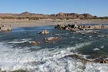 Orange River near Rosh Pinah (October 2016)
.jpg) Rosh Pinah Skorpion Airfield (2017)
Rosh Pinah Skorpion Airfield (2017)
External links
| Wikimedia Commons has media related to Rosh Pinah. |
References
- "Table 4.2.2 Urban population by Census years (2001 and 2011)" (PDF). Namibia 2011 - Population and Housing Census Main Report. Namibia Statistics Agency. p. 39. Archived from the original (PDF) on 2 October 2013. Retrieved 10 September 2013.
- "Small business flocks to Rosh Pinah". Namibia Economist. 18 April 2008.
- Sasman, Catherine (10 November 2010). "Karas profile". New Era.
- Tonchi, Victor L., William A. Lindeke, and John J. Grotpeter, "Rosh Pinah Mine" Historical Dictionary of Namibia. 2nd edition. (2012) Toronto: The Scarecrow Press, Inc, p. 373.
- Cassidy, Joseph (2009). Place Names of Namibia A Historical Dictionary. Windhoek: Macmillan Education Namibia Publishers (Pty) Ltd. p. 97. ISBN 978-99916-0-654-5.
- "Rosh Pinah mine". Trevali Mining Corporation. Retrieved 11 May 2019.
- "Glencore buys 80% of Rosh Pinah". The Namibian. Mining Weekly. 16 December 2011.
- Hartman, Adam (May 2019). "Evolution of Namibia's mining towns". Mining Journal supplement to The Namibian. pp. 26–33.
- Shiku, Paulus (2 October 2012). "Lack of Business space at Rosh Pinah". The Namibian. p. 1.
- Miyanicwe, Clemans (20 August 2013). "Nine regions need 55 schools". The Namibian.
- Tuyeimo, Haidula (18 February 2016). "3 225 classrooms needed, Govt pleads for help". The Namibian.