Rosalie, Queensland
Rosalie is a former suburb of Brisbane, Queensland, Australia. Since 1975, it has been a neighbourhood within the suburb of Paddington.[1]
History
The name Rosalie is probably derived from the Rosalie Plains pastoral station leased by John Frederick McDougall, who also owned land in the Milton and Rosalie areas of Brisbane.[1]
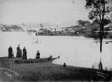
Floods along Bayswater Road, Rosalie, 1890
Rosalie was subject to flooding in the 1890 Brisbane floods.
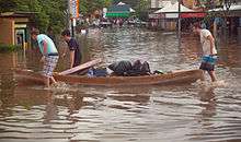
Evacuating from Rosalie, 2011
The lower parts of Rosalie were inundated in the 2011 Brisbane Floods.[2]
Amenities
The centre of Rosalie contains many local shops and restaurants. They are all located closely to the intersection of Baroona Road and Nash Street. Nearby parks and playgrounds include Gregory Park and Frew Park.
Heritage listings
Rosalie has a number of heritage-listed sites, including:
- 50 Elizabeth Street: Rosalie RSL Hall[3]
- 57 Elizabeth Street: Rosalie Community Kindergarten and Preschool[4]
- Fernberg Road: Marist Brothers College Rosalie Buildings[5]
References
- "Rosalie (entry 29020)". Queensland Place Names. Queensland Government. Retrieved 11 January 2015.
- "Residents rush to leave sinking Rosalie". Sydney Morning Herald. 12 January 2011. Archived from the original on 24 September 2015. Retrieved 12 January 2015.
- "RSL Hall Rosalie (entry 602517)". Queensland Heritage Register. Queensland Heritage Council. Retrieved 19 June 2013.
- "Rosalie Community Kindergarten and Preschool (entry 602380)". Queensland Heritage Register. Queensland Heritage Council. Retrieved 19 June 2013.
- "Marist Brothers' Monastery and Marist College (entry 602607)". Queensland Heritage Register. Queensland Heritage Council. Retrieved 6 July 2013.
External links
- "Reminisce in Rosalie" (PDF). Brisbane Heritage Trails. Brisbane City Council. 2013. Archived (PDF) from the original on 12 January 2015.
- Miles, A. T. (Allan T.) (1 January 1981), Rosalie - Brisbane's forgotten daughter, Royal Historical Society of Queensland — available online
- "Rosalie". Queensland Places. Centre for the Government of Queensland, University of Queensland.
This article is issued from Wikipedia. The text is licensed under Creative Commons - Attribution - Sharealike. Additional terms may apply for the media files.