Rome, Ellis County, Kansas
Rome was a short-lived postbellum frontier settlement in Ellis County, Kansas, United States.
Rome, Kansas | |
|---|---|
 | |
| Nickname(s): The Walled City[1] | |
| Coordinates: 38°52′43.59″N 99°20′39.71″W | |
| Country | United States |
| State | Kansas |
| County | Ellis |
| Elevation | 1,909 ft (582 m) |
| Time zone | UTC-6 (Central (CST)) |
| • Summer (DST) | UTC-5 (CDT) |


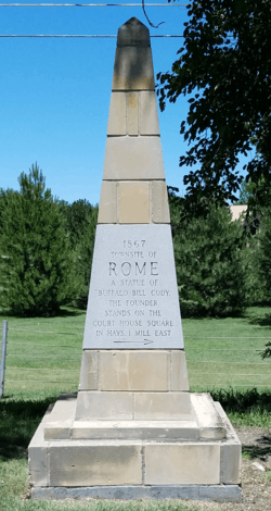
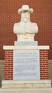
Rome is notable for its association with the early plains career of its co-founder, William Frederick "Buffalo Bill" Cody. Rome was the first town established within the future Ellis County, followed very shortly by rival Hays City.
History
In 1867, William Rose, a railroad contractor, and William Cody founded the townsite to take advantage of the recent relocation of Fort Hays adjacent to the planned crossing of Big Creek by the Kansas Pacific Railway. It soon became a recreation center for 1200 railroad construction workers. However, the railway's selection of Hays City for the station combined with the cholera outbreak in Rome the same summer resulted in the wholesale abandonment of the town in favor of Hays City.[2][3]
In 1868, the Clarkson Brothers, Charlie, Matthew, and George, set their buffalo hunting headquarters at the abandoned Rome site. By 1872, they had completed the requirements for their homestead claim on the land Rome had occupied.[4]
Although the town had quickly failed, Cody maintained an interest in the location. At the 1876 Centennial Exposition, Cody convinced I. M. Yost (the husband of a cousin) to build a water-powered grain mill at Rome. With assistance from soldiers from Fort Hays, Yost built a wooden dam there on Big Creek to power the mill and provide ice to the fort. While the dam was soon destroyed by animals and flooding and the mill by fire, Yost was committed to the locality and built more mills in and around Hays, and later founded nearby Yocemento.[1]
A map of Rome was reconstructed in the 1930s as a WPA project. This map was compiled by H. R. Pollock from newspaper articles, interviews, and correspondence with people with historical connection with the town, including I. M. Yost, the miller, C. L. Henderson, who had a farm adjoining Rome, and Simon Motz, an early settler in Rome.[4][5][6]
The historic townsite north of Noose Road is presently a private gated facility, managed by Rome Corporation.
Hangman's Bridge
In late-1867, the Kansas Pacific Railway completed a wooden through-truss bridge across Big Creek. Vigilantes active in early treeless Hays City used the bridge for hangings, and so it is known locally as Hangman's Bridge.[7] Although the bridge was a full mile west from the early Hays City, it adjoined Rome; the Clarkson brothers noted seeing a body hanging on the bridge (probably Jack McGee who had stabbed a police constable, Frank Sheperd).[4]
The bridge site is particularly associated with the 1869 lynching of three black soldiers of the 38th United States Colored Infantry Regiment.[8]
Transportation
The Kansas Pacific track defined the southern edge of the Rome townsite. Here, the railroad was constructed at a significantly elevated grade justified by the potential for flooding on Big Creek. However, town residents suspected that the excessively elevated tracks were built intentionally to interfere with commerce of the town. The combination of the high track with the deeply cut ravine of Big Creek surrounding the remaining boundaries of Rome resulted in the derisive nickname "The Walled City".[1] Today, the track is operated by the Union Pacific Railroad.
In 1867, the Ellis Trail passed along the north side of the town, crossing Big Creek at the east and west ends. The Butterfield Overland Despatch briefly operated a station in Rome, before relocating to Hays City.
Present day Noose Road passes through the townsite east and west, crossing Big Creek just north of Hangman's Bridge. This was the original U.S. Route 40 alignment (locally "Highway 40"). The United States Highway system vacated this alignment in 1947 when the highway and railroad tracks were realigned at Yocemento, moving the highway to the south of the tracks between Yocemento and Hays. This newer alignment lost the U.S. Route 40 designation when Interstate 70 was completed and the road was renamed Old Hwy 40.
Rome Road makes a short connection across the track between Noose Road and Old Hwy 40.
References
- W.A. Hill. "Rome - Predecessor of Hays Founded by "Buffalo Bill" Cody". The William F. Cody Archive. pp. 12–13. Retrieved 2018-07-18.
One of [Cody's] greatest contributions to Hays was when he got I. M. Yost to locate here.
- Kathy Weiser, ed. (2017). "Extinct Towns of Ellis County, Kansas". Legends of Kansas. Legends Of America. Retrieved 2018-03-29.
- Bob Maxwell (2009-11-25). "Hays' tumultuous beginnings originate in Rome". The Hays Daily News. Retrieved 2018-03-29.
- Rodney Staab, ed. (1982–1983). "The Mathew Clarkson Manuscripts" (PDF). Kansas History - A Journal of the Central Plains. 5 (4): 257, 259, 268.
Page 268 has a reprint of the WPA map.
CS1 maint: date format (link) - "Historical Mt. Allen Cemetery". City of Hays.
- H. R. Pollock. "Blueprint of Rome, Kansas". The William F. Cody Archive. Retrieved 2018-07-18.
- "Hangman's Bridge Hays City, Kansas". The Historical Marker Database. Retrieved 2018-07-19.
- James N. Leiker, University of Kansas. "Black Soldiers At Fort Hays, Kansas, 1867-1869 A Study In Civilian And Military Violence". Great Plains Quarterly. Center for Great Plains Studies, University of Nebraska - Lincoln (Winter 1997): 11–12.
Municipalities and communities of Ellis County, Kansas, United States | ||
|---|---|---|
| Cities | 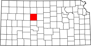 Map of Kansas highlighting Ellis County | |
| CDPs | ||
| Unincorporated communities | ||
| Ghost towns | ||
| Townships | ||