River Ant
The River Ant is a tributary river of the River Bure in the county of Norfolk, England.[1] It is 27 kilometres (17 mi) long (of which 8.75 miles are now navigable), and has an overall drop of 27 metres from source to mouth. It is said that the Ant was formerly known as the River Smale and that this is the origin of the name of the village of Smallburgh.[2]
| Ant | |
|---|---|
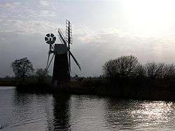 The river at How Hill | |
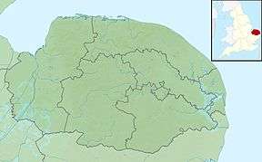 Location of the river mouth within Norfolk | |
| Location | |
| Country | England |
| Region | Norfolk |
| Physical characteristics | |
| Source | |
| ⁃ location | Antingham |
| ⁃ coordinates | 52.8507°N 1.3533°E |
| ⁃ elevation | 27 m (89 ft) |
| Mouth | River Bure |
⁃ location | Ant Mouth, south of Ludham Bridge |
⁃ coordinates | 52.6896°N 1.5131°E |
⁃ elevation | 0 m (0 ft) |
| Length | 27.3 km (17.0 mi) |
| Basin features | |
| River system | River Bure |
The river's source is just east of the village of Antingham in North Norfolk at Antingham Ponds. Just below the pools the river's route has been used as a canal in the past, starting at what was Antingham bone mill. An Act of Parliament established the North Walsham & Dilham Canal[3] in 1812, as a wide gauge canal able to take a Norfolk wherry. It was built at a cost of £30,000 and opened on 25 July 1826, making the river navigable as far as Dilham, where the river widens and deepens. It carried manure, offal, flour, coal, and farm produce. In 1885, the canal was sold for £600, but the canal company's solicitor disappeared with the money. The flood of 1912 washed away several staithes. The wherry "Ella" made the final trading journey on the canal from Bacton staithe in 1934. The canal was never nationalised and still belongs to the North Walsham Canal Company. The river, now in its canal form, curves around the north east of the town of North Walsham[3] passing Bacton Wood Mill. Below Bacton Mill the canal reaches a lock at Ebridge mill. The lock is in poor condition but it is hoped that this section of canal will one day be restored and made navigable again. Further on at Briggate Bridge there is another mill and another disused lock.
The Ant Broads & Marshes NNR is a national nature reserve.
Norfolk Broads (The Broads Authority)
River Ant | |||||||||||||||||||||||||||||||||||||||||||||||||||||||||||||||||||||||||||||||||||||||||||||||||||||||||||||||||||||||||||||||||||||||||||||||||||||||||||||||||||||||||||||||||||||||||||||
|---|---|---|---|---|---|---|---|---|---|---|---|---|---|---|---|---|---|---|---|---|---|---|---|---|---|---|---|---|---|---|---|---|---|---|---|---|---|---|---|---|---|---|---|---|---|---|---|---|---|---|---|---|---|---|---|---|---|---|---|---|---|---|---|---|---|---|---|---|---|---|---|---|---|---|---|---|---|---|---|---|---|---|---|---|---|---|---|---|---|---|---|---|---|---|---|---|---|---|---|---|---|---|---|---|---|---|---|---|---|---|---|---|---|---|---|---|---|---|---|---|---|---|---|---|---|---|---|---|---|---|---|---|---|---|---|---|---|---|---|---|---|---|---|---|---|---|---|---|---|---|---|---|---|---|---|---|---|---|---|---|---|---|---|---|---|---|---|---|---|---|---|---|---|---|---|---|---|---|---|---|---|---|---|---|---|---|---|---|---|
| |||||||||||||||||||||||||||||||||||||||||||||||||||||||||||||||||||||||||||||||||||||||||||||||||||||||||||||||||||||||||||||||||||||||||||||||||||||||||||||||||||||||||||||||||||||||||||||
At Honing Bridge the course enters The Broads, administered by The Broads Authority. Here the canal cuts through a marshy wooded area called Dilham Broad and again curves north east around the village of Dilham, passing under Tonnage Bridge. Below Tonnage Bridge are the last limits of the Navigation through Broad Fen before reverting to the river. Just before Wayford Bridge, a branch of the canal called Tyler’s Cut runs off to the west. This branch links the villages of Dilham and Smallburgh to the river and the rest of the broads although it is at the moment only navigable by very small boats. At Wayford Bridge the river passes the Wayford Bridge Hotel and its row of tiny houseboats lining the east bank of the river. There is only 8 feet of headroom under the bridge, which carries the A149 road, and the river is only three feet deep at this point, making it only passable by the smallest of pleasure craft.

Some years ago the ancient hard surface of the ‘ford’ which gave rise to the name "Wayford" was found on the river bed here. Just the other side of the bridge there are boat yards on both banks and the river follows a fairly straight course until it reaches the photogenic "Hunsett Drainage Mill". Here, where the river turns south and passes the channel leading to the staithes at Stalham and Sutton, the river banks of Barton Fen are crowded with trees, marshes, and reeds, the latter formerly harvested and used for thatching for centuries past.
The North Walsham & Dilham Canal is the canalisation of the Ant and joins it at Smallburgh junction.
Barton Broad
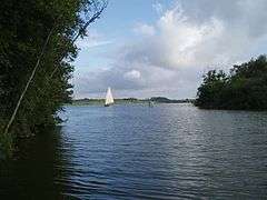
As the river nears Barton Broad it passes a triangular island called the Heater. The channels either side lead to Barton Turf staithe and its boatyard. The river now enters Barton Broad, the second largest of the Broads. Its crystal clear waters are the result of considerable effort and money spent to clean the broad up over the last few years. Barton Broad is unique in that it has an island, called "Pleasure Hill".
The last stretch
The Ant leaves Barton Broad at its south east corner and enters a stretch called "The Shoals". All around this area can be seen numerous drainage mills. The river meanders through the flat Broadland countryside, passing the drainage mills of Clayrack and Boardman’s on the east bank, and Turf Fen Drainage mill on the west bank. Here the river passes How Hill nature reserve, which is open to the public. From here it makes a wide horseshoe bend, passing Neaves Drainage mill as it heads towards Ludham Bridge. The Ant passes under the bridge carrying the A1062 road, and turns sharply east before straightening out a little. It then turns south and enters the river Bure at Ant Mouth, close to the ruins of St Benet’s Abbey.[3]
Shipping
The remains of a Saxon boat were found by the Environment Agency in August 2010 when working on the river during vital flood defence work. The boat, around 3 m (9.8 ft) long, had been hollowed out by hand from a single piece of oak and was found at the bottom of the river between Honing Hall and Brown's Hill. Five animal skulls were found near the boat, which was taken to specialists in York to be treated with special preservatives. Once the treatment has been completed the boat will be delivered to the Castle Museum in Norwich and put on display to the public.[4]
A special type of Norfolk wherry was used on the Ant, measuring up to 50 by 12 feet (15.2 m × 3.7 m).
Water quality
The Environment Agency measure the water quality of the river systems in England. Each is given an overall ecological status, which may be one of five levels: high, good, moderate, poor and bad. There are several components that are used to determine this, including biological status, which looks at the quantity and varieties of invertebrates, angiosperms and fish, and chemical status, which compares the concentrations of various chemicals against known safe concentrations. Chemical status is rated good or fail.[5]
The water quality of the River Ant system was as follows in 2016.
| Section | Ecological Status | Chemical Status | Overall Status | Length | Catchment | Channel |
|---|---|---|---|---|---|---|
| North Walsham and Dilham Canal[6] | style="background: #ffff99; text-align: center;" | Moderate | style="background: #7af58a; text-align: center;" | Good | style="background: #ffff99; text-align: center;" | Moderate | 14.0 miles (22.5 km) | 20.96 square miles (54.3 km2) | heavily modified |
| Smallburgh Watercourse[7] | style="background: #ffff99; text-align: center;" | Moderate | style="background: #7af58a; text-align: center;" | Good | style="background: #ffff99; text-align: center;" | Moderate | 3.4 miles (5.5 km) | 6.73 square miles (17.4 km2) | heavily modified |
| Ant (Dilham to R. Bure)[8] | style="background: #ffff99; text-align: center;" | Moderate | style="background: #7af58a; text-align: center;" | Good | style="background: #ffff99; text-align: center;" | Moderate | 8.0 miles (12.9 km) | 21.13 square miles (54.7 km2) | heavily modified |
The reasons for the quality being less than good are largely a result of the physical modification of the channel, and for the North Walsham and Dilham Canal section, the volume of surface water and groundwater abstracted for agriculture and land management. Some improvements have been made to this section, as it was rated Bad from 2013 to 2015.
References
- Ordnance Survey (2005). OS Explorer Map OL40 - The Broads. ISBN 0-319-23769-9.
- "History". Smallburgh Parish.
- Rivers of East Anglia, By James Turner: Publisher: Cassell & Company Limited (1954):ASIN B0007JD6TQ
- "Saxon boat uncovered in Norfolk's River Ant". BBC. 4 September 2010.
- "Glossary (see Biological quality element; Chemical status; and Ecological status)". Catchment Data Explorer. Environment Agency. Retrieved 15 May 2017.
- "North Walsham and Dilham Canal". Catchment Data Explorer. Environment Agency. Retrieved 11 July 2018.
- "Smallburgh Watercourse". Catchment Data Explorer. Environment Agency. Retrieved 11 July 2018.
- "Ant (Dilham to R. Bure)". Catchment Data Explorer. Environment Agency. Retrieved 13 July 2018.